

Anatomy of the Oceanic Ridge
Divergent Boundaries
Oceanic Ridges and Seafloor Spreading
Along well-developed divergent plate boundaries, the seafloor is elevated, forming a broad
linear swell called the oceanic ridge, or mid-ocean ridge. Our knowledge of the oceanic ridge
system comes from soundings of the ocean floor, core samples from deep-sea drilling, visual
inspection using deep-diving submersibles, and even firsthand inspection of slices of ocean
floor that have been thrust onto dry land during continental collisions. At oceanic ridges we
find extensive normal and strike-slip faulting, earthquakes, high heat flow, and volcanism.
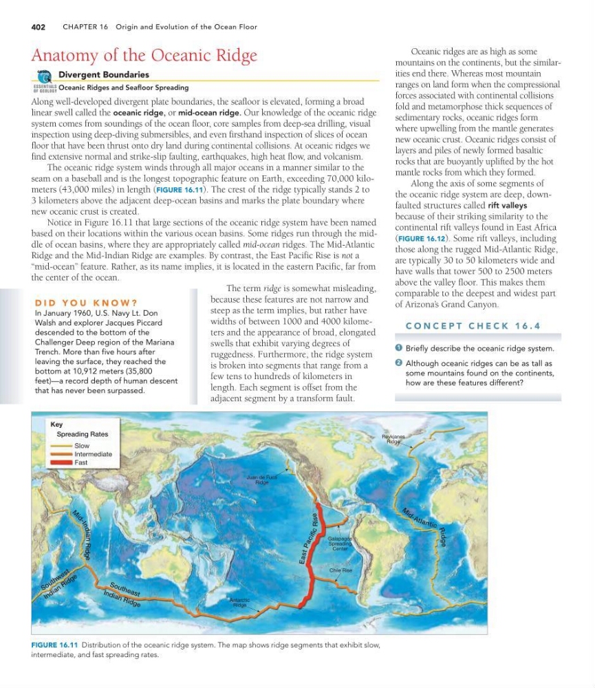
The oceanic ridge system winds through all major oceans in a manner similar to the
seam on a baseball and is the longest topographic feature on Earth, exceeding 70,000 kilometers (43,000 miles) in length (FIGURE 16.11). The crest of the ridge typically stands 2 to
3 kilometers above the adjacent deep-ocean basins and marks the plate boundary where
new oceanic crust is created.
Notice in Figure 16.11 that large sections of the oceanic ridge system have been named
based on their locations within the various ocean basins. Some ridges run through the middle of ocean basins, where they are appropriately called mid-ocean ridges. The Mid-Atlantic
Ridge and the Mid-Indian Ridge are examples. By contrast, the East Pacific Rise is not a
“mid-ocean” feature. Rather, as its name implies, it is located in the eastern Pacific, far from
the center of the ocean.
The term ridge is somewhat misleading,
because these features are not narrow and
steep as the term implies, but rather have
widths of between 1000 and 4000 kilometers and the appearance of broad, elongated
swells that exhibit varying degrees of
ruggedness. Furthermore, the ridge system
is broken into segments that range from a
few tens to hundreds of kilometers in
length. Each segment is offset from the
adjacent segment by a transform fault.
GEODe
ESSENTIALS
OF GEOLOGY
Reykjanes
Ridge
Juan de Fuca
Ridge
Chile Rise
Antarctic
Ridge
Galapagos
Spreading
Center
Spreading Rates
Slow
Intermediate
Fast
Key
S o u th e a s t
S o u t h w e s t
In d ia n R id g e
I n d i a n R i d g e
M
i
d
-
I
n
d
ian
Rid
ge
Ea s t P a c i f ic Rise
M i d - A tl a n ti c
R
idg
e
FIGURE 16.11 Distribution of the oceanic ridge system. The map shows ridge segments that exhibit slow,
intermediate, and fast spreading rates.
CHAPTER 16 Origin and Evolution of the Ocean Floor
402
Oceanic ridges are as high as some
mountains on the continents, but the similarities end there. Whereas most mountain
ranges on land form when the compressional
forces associated with continental collisions
fold and metamorphose thick sequences of
sedimentary rocks, oceanic ridges form
where upwelling from the mantle generates
new oceanic crust. Oceanic ridges consist of
layers and piles of newly formed basaltic
rocks that are buoyantly uplifted by the hot
mantle rocks from which they formed.
Along the axis of some segments of
the oceanic ridge system are deep, downfaulted structures called rift valleys
because of their striking similarity to the
continental rift valleys found in East Africa
(FIGURE 16.12). Some rift valleys, including
those along the rugged Mid-Atlantic Ridge,
are typically 30 to 50 kilometers wide and
have walls that tower 500 to 2500 meters
above the valley floor. This makes them
comparable to the deepest and widest part
of Arizona’ s Grand Canyon.
C O N C E P T C H E C K 1 6 . 4
Briefly describe the oceanic ridge system.
Although oceanic ridges can be as tall as
some mountains found on the continents,
how are these features different?
2
1
D I D Y O U K N O W ?
In January 1960, U.S. Navy Lt. Don
Walsh and explorer Jacques Piccard
descended to the bottom of the
Challenger Deep region of the Mariana
Trench. More than five hours after
leaving the surface, they reached the
bottom at 10,912 meters (35,800
feet)—a record depth of human descent
that has never been surpassed.
Divergent Boundaries
Oceanic Ridges and Seafloor Spreading
Along well-developed divergent plate boundaries, the seafloor is elevated, forming a broad
linear swell called the oceanic ridge, or mid-ocean ridge. Our knowledge of the oceanic ridge
system comes from soundings of the ocean floor, core samples from deep-sea drilling, visual
inspection using deep-diving submersibles, and even firsthand inspection of slices of ocean
floor that have been thrust onto dry land during continental collisions. At oceanic ridges we
find extensive normal and strike-slip faulting, earthquakes, high heat flow, and volcanism.
The oceanic ridge system winds through all major oceans in a manner similar to the
seam on a baseball and is the longest topographic feature on Earth, exceeding 70,000 kilometers (43,000 miles) in length (FIGURE 16.11). The crest of the ridge typically stands 2 to
3 kilometers above the adjacent deep-ocean basins and marks the plate boundary where
new oceanic crust is created.
Notice in Figure 16.11 that large sections of the oceanic ridge system have been named
based on their locations within the various ocean basins. Some ridges run through the middle of ocean basins, where they are appropriately called mid-ocean ridges. The Mid-Atlantic
Ridge and the Mid-Indian Ridge are examples. By contrast, the East Pacific Rise is not a
“mid-ocean” feature. Rather, as its name implies, it is located in the eastern Pacific, far from
the center of the ocean.
The term ridge is somewhat misleading,
because these features are not narrow and
steep as the term implies, but rather have
widths of between 1000 and 4000 kilometers and the appearance of broad, elongated
swells that exhibit varying degrees of
ruggedness. Furthermore, the ridge system
is broken into segments that range from a
few tens to hundreds of kilometers in
length. Each segment is offset from the
adjacent segment by a transform fault.
GEODe
ESSENTIALS
OF GEOLOGY
Reykjanes
Ridge
Juan de Fuca
Ridge
Chile Rise
Antarctic
Ridge
Galapagos
Spreading
Center
Spreading Rates
Slow
Intermediate
Fast
Key
S o u th e a s t
S o u t h w e s t
In d ia n R id g e
I n d i a n R i d g e
M
i
d
-
I
n
d
ian
Rid
ge
Ea s t P a c i f ic Rise
M i d - A tl a n ti c
R
idg
e
FIGURE 16.11 Distribution of the oceanic ridge system. The map shows ridge segments that exhibit slow,
intermediate, and fast spreading rates.
CHAPTER 16 Origin and Evolution of the Ocean Floor
402
Oceanic ridges are as high as some
mountains on the continents, but the similarities end there. Whereas most mountain
ranges on land form when the compressional
forces associated with continental collisions
fold and metamorphose thick sequences of
sedimentary rocks, oceanic ridges form
where upwelling from the mantle generates
new oceanic crust. Oceanic ridges consist of
layers and piles of newly formed basaltic
rocks that are buoyantly uplifted by the hot
mantle rocks from which they formed.
Along the axis of some segments of
the oceanic ridge system are deep, downfaulted structures called rift valleys
because of their striking similarity to the
continental rift valleys found in East Africa
(FIGURE 16.12). Some rift valleys, including
those along the rugged Mid-Atlantic Ridge,
are typically 30 to 50 kilometers wide and
have walls that tower 500 to 2500 meters
above the valley floor. This makes them
comparable to the deepest and widest part
of Arizona’ s Grand Canyon.
C O N C E P T C H E C K 1 6 . 4
Briefly describe the oceanic ridge system.
Although oceanic ridges can be as tall as
some mountains found on the continents,
how are these features different?
2
1
D I D Y O U K N O W ?
In January 1960, U.S. Navy Lt. Don
Walsh and explorer Jacques Piccard
descended to the bottom of the
Challenger Deep region of the Mariana
Trench. More than five hours after
leaving the surface, they reached the
bottom at 10,912 meters (35,800
feet)—a record depth of human descent
that has never been surpassed.