

North
America
Africa
South
America
Antarctica Australia
India
Eurasia
A. 200 Million Years Ago
(Late Triassic Period)
B. 150 Million Years Ago
(Late Jurassic Period)
C. 90 Million Years Ago
(Cretaceous Period)
S.E.
Asia
Tethys
Sea
P
A
N
G
A E A
D. 50 Million Years Ago
(Early Tertiary/Paleogene)
F. Present
Tibet
North
America
Africa
South
America
Antarctica
Australia
India
Eurasia
Tibet
North
America
Africa
South
America
Antarctica
Australia
India
Eurasia
North
America
Africa
South
America
Antarctica
Australia
India
Eurasia
Gulf of
California
Red
Sea
Panama
Arabia
Tethys
Ocean
E. 20 Million Years Ago
(Late Tertiary/Neogene)
H im ala y a s
385
How Is Plate Motion Measured?
the speed and direction of plate movement
relative to the hot plume embedded in the
mantle below.
Mantle Plumes
and Plate Motions
By measuring the length of a hot spot track
and the time interval between the formation
of its oldest and youngest volcanic structures, an average rate of plate motion can be
calculated. For example, that portion of the
Hawaiian Island–Emperor Seamount chain
that extends from Hawaii to Suiko Seamount
is roughly 6000 kilometers in length and
formed over the past 65 million years. Thus,
the average rate of movement of the Pacific
plate, relative to the mantle plume, was
about 9 centimeters (4 inches) per year.
Hot spot tracks can also be useful
when establishing the direction a plate is
moving. Notice in Figure 15.19 that there
is a bend in the Hawaiian Island–Emperor
Seamount chain. This bend occurred about
50 million years ago when the motion of
the Pacific plate changed from one that was
nearly due north to a more northwesterly
path. Similarly, hot spots found on the floor
of the Atlantic have increased our understanding of the migration of landmasses
following the break-up of Pangaea.
The existence of mantle plumes and
their association with hot spots is well
documented. Most mantle plumes are longlived features that appear to maintain relatively fixed positions within the mantle.
However, recent evidence has shown that
some hot spots may slowly migrate. Preliminary results suggest that the Hawaiian
hotspot may have migrated southward by as
much as 20 degrees latitude. If this is the
case, models of past plate motion that were
based on a “fixed hot spot” frame of
reference will need to be reevaluated.
Measuring Plate Motion
from Space
Plates are not flat surfaces; instead they are
curved sections of a sphere, which greatly
complicates how plate motion is
described. In addition, plates usually
exhibit some degree of rotational motion,
which can cause two locations on the
same plate to move at different speeds and
in different directions. The latter fact can
be illustrated by rotating your dinner plate
in a clockwise matter. When doing so you
will notice that the items on the left side
of the plate move away from you (divergence) as the items on the right side move
toward you (convergence). Items in the
center will rotate, but their position relative to yours will not change. The complex
nature of plate motion makes the task of
describing plate motions more difficult
than simply establishing the relative
motion between two plates along the
boundary that separates them. Fortunately,
using space-age technology, researchers
have recently been able to accurately calculate the absolute motion of hundreds of
locations across the globe.
You may be familiar with the Global
Positioning System (GPS), which is part of
the navigation system used in automobiles
to locate one’ s position and to provide
directions to some other location. The
Global Positioning System employs two
dozen satellites that send radio signals that
are intercepted by GPS receivers located at
Earth’ s surface. The exact position of the
receiver is determined by simultaneously
establishing the distance from the receiver
to four or more satellites. Researchers use
specifically designed equipment that is able
to locate the position of a point on Earth to
within a few millimeters (about the
diameter of a small pea). To establish plate
motion, a particular site is surveyed repeatedly over a number of years.
Data obtained from these and other
similar techniques are shown in FIGURE
15.27. Calculations show that Hawaii is
moving in a northwesterly direction and
approaching Japan at 8.3 centimeters per
year. A site located in Maryland is retreating
from one in England at a speed of 1.7 centimeters per year—a value that is close to
the 2.0-centimeters-per-year spreading rate
that was established from paleomagnetic
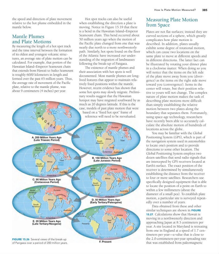
FIGURE 15.26 Several views of the break-up
of Pangaea over a period of 200 million years.
America
Africa
South
America
Antarctica Australia
India
Eurasia
A. 200 Million Years Ago
(Late Triassic Period)
B. 150 Million Years Ago
(Late Jurassic Period)
C. 90 Million Years Ago
(Cretaceous Period)
S.E.
Asia
Tethys
Sea
P
A
N
G
A E A
D. 50 Million Years Ago
(Early Tertiary/Paleogene)
F. Present
Tibet
North
America
Africa
South
America
Antarctica
Australia
India
Eurasia
Tibet
North
America
Africa
South
America
Antarctica
Australia
India
Eurasia
North
America
Africa
South
America
Antarctica
Australia
India
Eurasia
Gulf of
California
Red
Sea
Panama
Arabia
Tethys
Ocean
E. 20 Million Years Ago
(Late Tertiary/Neogene)
H im ala y a s
385
How Is Plate Motion Measured?
the speed and direction of plate movement
relative to the hot plume embedded in the
mantle below.
Mantle Plumes
and Plate Motions
By measuring the length of a hot spot track
and the time interval between the formation
of its oldest and youngest volcanic structures, an average rate of plate motion can be
calculated. For example, that portion of the
Hawaiian Island–Emperor Seamount chain
that extends from Hawaii to Suiko Seamount
is roughly 6000 kilometers in length and
formed over the past 65 million years. Thus,
the average rate of movement of the Pacific
plate, relative to the mantle plume, was
about 9 centimeters (4 inches) per year.
Hot spot tracks can also be useful
when establishing the direction a plate is
moving. Notice in Figure 15.19 that there
is a bend in the Hawaiian Island–Emperor
Seamount chain. This bend occurred about
50 million years ago when the motion of
the Pacific plate changed from one that was
nearly due north to a more northwesterly
path. Similarly, hot spots found on the floor
of the Atlantic have increased our understanding of the migration of landmasses
following the break-up of Pangaea.
The existence of mantle plumes and
their association with hot spots is well
documented. Most mantle plumes are longlived features that appear to maintain relatively fixed positions within the mantle.
However, recent evidence has shown that
some hot spots may slowly migrate. Preliminary results suggest that the Hawaiian
hotspot may have migrated southward by as
much as 20 degrees latitude. If this is the
case, models of past plate motion that were
based on a “fixed hot spot” frame of
reference will need to be reevaluated.
Measuring Plate Motion
from Space
Plates are not flat surfaces; instead they are
curved sections of a sphere, which greatly
complicates how plate motion is
described. In addition, plates usually
exhibit some degree of rotational motion,
which can cause two locations on the
same plate to move at different speeds and
in different directions. The latter fact can
be illustrated by rotating your dinner plate
in a clockwise matter. When doing so you
will notice that the items on the left side
of the plate move away from you (divergence) as the items on the right side move
toward you (convergence). Items in the
center will rotate, but their position relative to yours will not change. The complex
nature of plate motion makes the task of
describing plate motions more difficult
than simply establishing the relative
motion between two plates along the
boundary that separates them. Fortunately,
using space-age technology, researchers
have recently been able to accurately calculate the absolute motion of hundreds of
locations across the globe.
You may be familiar with the Global
Positioning System (GPS), which is part of
the navigation system used in automobiles
to locate one’ s position and to provide
directions to some other location. The
Global Positioning System employs two
dozen satellites that send radio signals that
are intercepted by GPS receivers located at
Earth’ s surface. The exact position of the
receiver is determined by simultaneously
establishing the distance from the receiver
to four or more satellites. Researchers use
specifically designed equipment that is able
to locate the position of a point on Earth to
within a few millimeters (about the
diameter of a small pea). To establish plate
motion, a particular site is surveyed repeatedly over a number of years.
Data obtained from these and other
similar techniques are shown in FIGURE
15.27. Calculations show that Hawaii is
moving in a northwesterly direction and
approaching Japan at 8.3 centimeters per
year. A site located in Maryland is retreating
from one in England at a speed of 1.7 centimeters per year—a value that is close to
the 2.0-centimeters-per-year spreading rate
that was established from paleomagnetic
FIGURE 15.26 Several views of the break-up
of Pangaea over a period of 200 million years.