

CHAPTER 15 Plate Tectonics: A Scientific Revolution Unfolds
366
Antarctica
Antarctica
Australia
Australia
A.
B.
C.
India
India
Africa
Africa
South
America
South
America
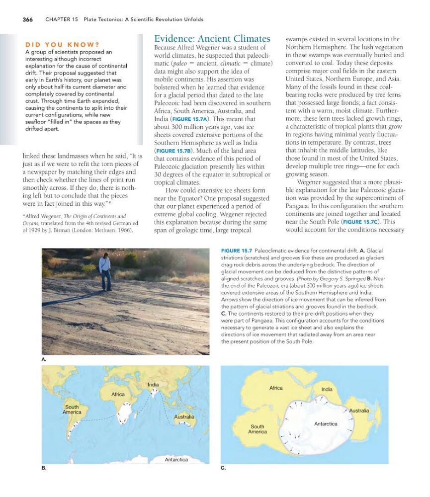
FIGURE 15.7 Paleoclimatic evidence for continental drift. A. Glacial
striations (scratches) and grooves like these are produced as glaciers
drag rock debris across the underlying bedrock. The direction of
glacial movement can be deduced from the distinctive patterns of
aligned scratches and grooves. (Photo by Gregory S. Springer) B. Near
the end of the Paleozoic era (about 300 million years ago) ice sheets
covered extensive areas of the Southern Hemisphere and India.
Arrows show the direction of ice movement that can be inferred from
the pattern of glacial striations and grooves found in the bedrock.
C. The continents restored to their pre-drift positions when they
were part of Pangaea. This configuration accounts for the conditions
necessary to generate a vast ice sheet and also explains the
directions of ice movement that radiated away from an area near
the present position of the South Pole.
linked these landmasses when he said, “It is
just as if we were to refit the torn pieces of
a newspaper by matching their edges and
then check whether the lines of print run
smoothly across. If they do, there is nothing left but to conclude that the pieces
were in fact joined in this way.”*
Evidence: Ancient Climates
Because Alfred Wegener was a student of
world climates, he suspected that paleoclimatic (
,
)
data might also support the idea of
mobile continents. His assertion was
bolstered when he learned that evidence
for a glacial period that dated to the late
Paleozoic had been discovered in southern
Africa, South America, Australia, and
India (FIGURE 15.7A). This meant that
about 300 million years ago, vast ice
sheets covered extensive portions of the
Southern Hemisphere as well as India
(FIGURE 15.7B). Much of the land area
that contains evidence of this period of
Paleozoic glaciation presently lies within
30 degrees of the equator in subtropical or
tropical climates.
How could extensive ice sheets form
near the Equator? One proposal suggested
that our planet experienced a period of
extreme global cooling. Wegener rejected
this explanation because during the same
span of geologic time, large tropical
climatic = climate
paleo = ancient
*Alfred Wegener, The Origin of Continents and
Oceans, translated from the 4th revised German ed.
of 1929 by J. Birman (London: Methuen, 1966).
D I D Y O U K N O W ?
A group of scientists proposed an
interesting although incorrect
explanation for the cause of continental
drift. Their proposal suggested that
early in Earth’s history, our planet was
only about half its current diameter and
completely covered by continental
crust. Through time Earth expanded,
causing the continents to split into their
current configurations, while new
seafloor “filled in” the spaces as they
drifted apart.
swamps existed in several locations in the
Northern Hemisphere. The lush vegetation
in these swamps was eventually buried and
converted to coal. Today these deposits
comprise major coal fields in the eastern
United States, Northern Europe, and Asia.
Many of the fossils found in these coalbearing rocks were produced by tree ferns
that possessed large fronds; a fact consistent with a warm, moist climate. Furthermore, these fern trees lacked growth rings,
a characteristic of tropical plants that grow
in regions having minimal yearly fluctuations in temperature. By contrast, trees
that inhabit the middle latitudes, like
those found in most of the United States,
develop multiple tree rings—one for each
growing season.
Wegener suggested that a more plausible explanation for the late Paleozoic glaciation was provided by the supercontinent of
Pangaea. In this configuration the southern
continents are joined together and located
near the South Pole (FIGURE 15.7C). This
would account for the conditions necessary
366
Antarctica
Antarctica
Australia
Australia
A.
B.
C.
India
India
Africa
Africa
South
America
South
America
FIGURE 15.7 Paleoclimatic evidence for continental drift. A. Glacial
striations (scratches) and grooves like these are produced as glaciers
drag rock debris across the underlying bedrock. The direction of
glacial movement can be deduced from the distinctive patterns of
aligned scratches and grooves. (Photo by Gregory S. Springer) B. Near
the end of the Paleozoic era (about 300 million years ago) ice sheets
covered extensive areas of the Southern Hemisphere and India.
Arrows show the direction of ice movement that can be inferred from
the pattern of glacial striations and grooves found in the bedrock.
C. The continents restored to their pre-drift positions when they
were part of Pangaea. This configuration accounts for the conditions
necessary to generate a vast ice sheet and also explains the
directions of ice movement that radiated away from an area near
the present position of the South Pole.
linked these landmasses when he said, “It is
just as if we were to refit the torn pieces of
a newspaper by matching their edges and
then check whether the lines of print run
smoothly across. If they do, there is nothing left but to conclude that the pieces
were in fact joined in this way.”*
Evidence: Ancient Climates
Because Alfred Wegener was a student of
world climates, he suspected that paleoclimatic (
,
)
data might also support the idea of
mobile continents. His assertion was
bolstered when he learned that evidence
for a glacial period that dated to the late
Paleozoic had been discovered in southern
Africa, South America, Australia, and
India (FIGURE 15.7A). This meant that
about 300 million years ago, vast ice
sheets covered extensive portions of the
Southern Hemisphere as well as India
(FIGURE 15.7B). Much of the land area
that contains evidence of this period of
Paleozoic glaciation presently lies within
30 degrees of the equator in subtropical or
tropical climates.
How could extensive ice sheets form
near the Equator? One proposal suggested
that our planet experienced a period of
extreme global cooling. Wegener rejected
this explanation because during the same
span of geologic time, large tropical
climatic = climate
paleo = ancient
*Alfred Wegener, The Origin of Continents and
Oceans, translated from the 4th revised German ed.
of 1929 by J. Birman (London: Methuen, 1966).
D I D Y O U K N O W ?
A group of scientists proposed an
interesting although incorrect
explanation for the cause of continental
drift. Their proposal suggested that
early in Earth’s history, our planet was
only about half its current diameter and
completely covered by continental
crust. Through time Earth expanded,
causing the continents to split into their
current configurations, while new
seafloor “filled in” the spaces as they
drifted apart.
swamps existed in several locations in the
Northern Hemisphere. The lush vegetation
in these swamps was eventually buried and
converted to coal. Today these deposits
comprise major coal fields in the eastern
United States, Northern Europe, and Asia.
Many of the fossils found in these coalbearing rocks were produced by tree ferns
that possessed large fronds; a fact consistent with a warm, moist climate. Furthermore, these fern trees lacked growth rings,
a characteristic of tropical plants that grow
in regions having minimal yearly fluctuations in temperature. By contrast, trees
that inhabit the middle latitudes, like
those found in most of the United States,
develop multiple tree rings—one for each
growing season.
Wegener suggested that a more plausible explanation for the late Paleozoic glaciation was provided by the supercontinent of
Pangaea. In this configuration the southern
continents are joined together and located
near the South Pole (FIGURE 15.7C). This
would account for the conditions necessary