

The killer waves generated by this
massive quake achieved heights as great as
10 meters (33 feet) and struck many
unprepared areas during a three-hour span
following the earthquake. Although the
Pacific basin had a tsunami warning system
in place, the Indian Ocean unfortunately
did not. The rarity of tsunami in the Indian
Ocean also contributed to a lack of preparedness. It should come as no surprise
that a tsunami warning system for
the Indian Ocean was subsequently
established.
TSUNAMI WARNING SYSTEM. In 1946, a
large tsunami struck the Hawaiian Islands
without warning. A wave more than
15 meters (50 feet) high left several coastal
villages in shambles. This destruction
motivated the U.S. Coast and Geodetic
Survey to establish a tsunami warning
system for coastal areas of the Pacific.
Seismic observatories throughout the
region report large earthquakes to the
Tsunami Warning Center in Honolulu.
Scientists at the Center use deep-sea buoys
equipped with pressure sensors to detect
energy released by an earthquake. In addition, tidal gauges measure the rise and fall
in sea level that accompany tsunami,
resulting in warnings issued within the
hour. Although tsunami travel very rapidly,
there is sufficient time to evacuate all but
the areas nearest the epicenter. For example, a tsunami generated off the coast of
Chile in 2010 took about 15 hours to
reach the Hawaiian Islands (FIGURE 14.23).
C O N C E P T C H E C K 1 4 . 8
List four factors that affect the amount of destruction caused by seismic vibrations.
In addition to the destruction created directly by seismic vibrations, list three other types of
destruction associated with earthquakes.
What is a tsunami? How is one generated?
Cite at least three reasons an earthquake with a moderate magnitude might cause more
extensive damage than a quake with a high magnitude.
4
3
2
1
D I D Y O U K N O W ?
Although there are no historical records
of a tsunami produced by a meteorite
impact in the ocean, such events have
occurred. Geologic evidence indicates
that the most recent occurrence was a
megatsunami that devastated portions
of the Australian coast about the year
1500. A meteorite impact 65 million
years ago near Mexico’s Yucatan
Peninsula created one of the largest
impact-induced tsunami ever. The giant
wave swept hundreds of kilometers
inland around the shore of the Gulf of
Mexico.
B.
A.
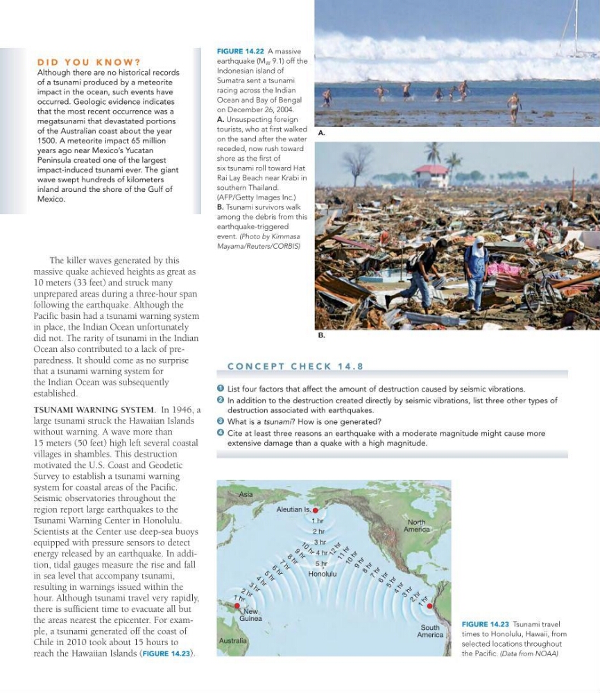
FIGURE 14.22 A massive
earthquake (M W 9.1) off the
Indonesian island of
Sumatra sent a tsunami
racing across the Indian
Ocean and Bay of Bengal
on December 26, 2004.
A. Unsuspecting foreign
tourists, who at first walked
on the sand after the water
receded, now rush toward
shore as the first of
six tsunami roll toward Hat
Rai Lay Beach near Krabi in
southern Thailand.
(AFP/Getty Images Inc.)
B. Tsunami survivors walk
among the debris from this
earthquake-triggered
event. (Photo by Kimmasa
Mayama/Reuters/CORBIS)
Honolulu
1
h r
2
h r
3
h r
4 h r
5 h r
6
h r
7
h r
8
h r
9
h r
1 0
h r
1 1
h r
1 2
h r
South
America
Aleutian Is.
Australia
3 h r
4 h r
5 h r
6 h r
7 h r
8 h r
9 h r
1 0 h r
2 hr
3 hr
4 hr
5 hr
1 hr
1 h r
2 h r
North
America
New
Guinea
Asia
FIGURE 14.23 Tsunami travel
times to Honolulu, Hawaii, from
selected locations throughout
the Pacific. (Data from NOAA)
massive quake achieved heights as great as
10 meters (33 feet) and struck many
unprepared areas during a three-hour span
following the earthquake. Although the
Pacific basin had a tsunami warning system
in place, the Indian Ocean unfortunately
did not. The rarity of tsunami in the Indian
Ocean also contributed to a lack of preparedness. It should come as no surprise
that a tsunami warning system for
the Indian Ocean was subsequently
established.
TSUNAMI WARNING SYSTEM. In 1946, a
large tsunami struck the Hawaiian Islands
without warning. A wave more than
15 meters (50 feet) high left several coastal
villages in shambles. This destruction
motivated the U.S. Coast and Geodetic
Survey to establish a tsunami warning
system for coastal areas of the Pacific.
Seismic observatories throughout the
region report large earthquakes to the
Tsunami Warning Center in Honolulu.
Scientists at the Center use deep-sea buoys
equipped with pressure sensors to detect
energy released by an earthquake. In addition, tidal gauges measure the rise and fall
in sea level that accompany tsunami,
resulting in warnings issued within the
hour. Although tsunami travel very rapidly,
there is sufficient time to evacuate all but
the areas nearest the epicenter. For example, a tsunami generated off the coast of
Chile in 2010 took about 15 hours to
reach the Hawaiian Islands (FIGURE 14.23).
C O N C E P T C H E C K 1 4 . 8
List four factors that affect the amount of destruction caused by seismic vibrations.
In addition to the destruction created directly by seismic vibrations, list three other types of
destruction associated with earthquakes.
What is a tsunami? How is one generated?
Cite at least three reasons an earthquake with a moderate magnitude might cause more
extensive damage than a quake with a high magnitude.
4
3
2
1
D I D Y O U K N O W ?
Although there are no historical records
of a tsunami produced by a meteorite
impact in the ocean, such events have
occurred. Geologic evidence indicates
that the most recent occurrence was a
megatsunami that devastated portions
of the Australian coast about the year
1500. A meteorite impact 65 million
years ago near Mexico’s Yucatan
Peninsula created one of the largest
impact-induced tsunami ever. The giant
wave swept hundreds of kilometers
inland around the shore of the Gulf of
Mexico.
B.
A.
FIGURE 14.22 A massive
earthquake (M W 9.1) off the
Indonesian island of
Sumatra sent a tsunami
racing across the Indian
Ocean and Bay of Bengal
on December 26, 2004.
A. Unsuspecting foreign
tourists, who at first walked
on the sand after the water
receded, now rush toward
shore as the first of
six tsunami roll toward Hat
Rai Lay Beach near Krabi in
southern Thailand.
(AFP/Getty Images Inc.)
B. Tsunami survivors walk
among the debris from this
earthquake-triggered
event. (Photo by Kimmasa
Mayama/Reuters/CORBIS)
Honolulu
1
h r
2
h r
3
h r
4 h r
5 h r
6
h r
7
h r
8
h r
9
h r
1 0
h r
1 1
h r
1 2
h r
South
America
Aleutian Is.
Australia
3 h r
4 h r
5 h r
6 h r
7 h r
8 h r
9 h r
1 0 h r
2 hr
3 hr
4 hr
5 hr
1 hr
1 h r
2 h r
North
America
New
Guinea
Asia
FIGURE 14.23 Tsunami travel
times to Honolulu, Hawaii, from
selected locations throughout
the Pacific. (Data from NOAA)