

Higher
high tide
Lower high tide
N
S
To
Moon
CHAPTER 13 Shorelines
330
mutual attractive force between
two bodies, as between Earth and the
Moon. Because the atmosphere and the
ocean both are fluids and thus free to move, both are
deformed by this force. Hence, ocean tides result
from the gravitational attraction exerted upon Earth
by the Moon and, to a lesser extent, by the Sun.
Causes of Tides
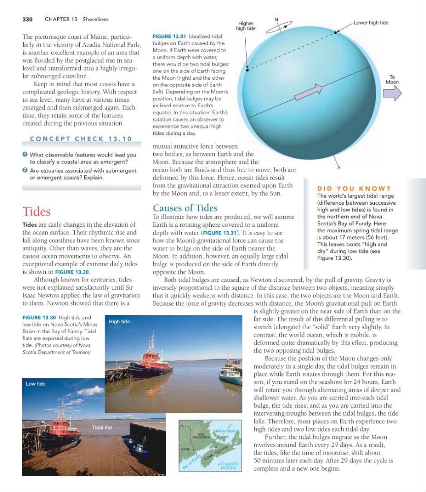
To illustrate how tides are produced, we will assume
Earth is a rotating sphere covered to a uniform
depth with water (FIGURE 13.31). It is easy to see
how the Moon’ s gravitational force can cause the
water to bulge on the side of Earth nearer the
Moon. In addition, however, an equally large tidal
bulge is produced on the side of Earth directly
opposite the Moon.
Both tidal bulges are caused, as Newton discovered, by the pull of gravity. Gravity is
inversely proportional to the square of the distance between two objects, meaning simply
that it quickly weakens with distance. In this case, the two objects are the Moon and Earth.
Because the force of gravity decreases with distance, the Moon’ s gravitational pull on Earth
is slightly greater on the near side of Earth than on the
far side. The result of this differential pulling is to
stretch (elongate) the “solid” Earth very slightly. In
contrast, the world ocean, which is mobile, is
deformed quite dramatically by this effect, producing
the two opposing tidal bulges.
Because the position of the Moon changes only
moderately in a single day, the tidal bulges remain in
place while Earth rotates through them. For this reason, if you stand on the seashore for 24 hours, Earth
will rotate you through alternating areas of deeper and
shallower water. As you are carried into each tidal
bulge, the tide rises, and as you are carried into the
intervening troughs between the tidal bulges, the tide
falls. Therefore, most places on Earth experience two
high tides and two low tides each tidal day.
Further, the tidal bulges migrate as the Moon
revolves around Earth every 29 days. As a result,
the tides, like the time of moonrise, shift about
50 minutes later each day. After 29 days the cycle is
complete and a new one begins.
NEW
BRUNSWICK
MAINE
N O V A
S C O T IA
ATLANTIC
OCEAN
B a y o f F u n d y
Minas Basin
Low tide
Tidal flat
High tide
FIGURE 13.30 High tide and
low tide on Nova Scotia’s Minas
Basin in the Bay of Fundy. Tidal
flats are exposed during low
tide. (Photos courtesy of Nova
Scotia Department of Tourism)
The picturesque coast of Maine, particularly in the vicinity of Acadia National Park,
is another excellent example of an area that
was flooded by the postglacial rise in sea
level and transformed into a highly irregular submerged coastline.
Keep in mind that most coasts have a
complicated geologic history. With respect
to sea level, many have at various times
emerged and then submerged again. Each
time, they retain some of the features
created during the previous situation.
C O N C E P T C H E C K 1 3 . 1 0
What observable features would lead you
to classify a coastal area as emergent?
Are estuaries associated with submergent
or emergent coasts? Explain.
Tides
Tides are daily changes in the elevation of
the ocean surface. Their rhythmic rise and
fall along coastlines have been known since
antiquity. Other than waves, they are the
easiest ocean movements to observe. An
exceptional example of extreme daily tides
is shown in FIGURE 13.30.
Although known for centuries, tides
were not explained satisfactorily until Sir
Isaac Newton applied the law of gravitation
to them. Newton showed that there is a
2
1
FIGURE 13.31 Idealized tidal
bulges on Earth caused by the
Moon. If Earth were covered to
a uniform depth with water,
there would be two tidal bulges:
one on the side of Earth facing
the Moon (right) and the other
on the opposite side of Earth
(left). Depending on the Moon’s
position, tidal bulges may be
inclined relative to Earth’s
equator. In this situation, Earth’s
rotation causes an observer to
experience two unequal high
tides during a day.
D I D Y O U K N O W ?
The world’s largest tidal range
(difference between successive
high and low tides) is found in
the northern end of Nova
Scotia’s Bay of Fundy. Here
the maximum spring tidal range
is about 17 meters (56 feet).
This leaves boats “high and
dry” during low tide (see
Figure 13.30).
high tide
Lower high tide
N
S
To
Moon
CHAPTER 13 Shorelines
330
mutual attractive force between
two bodies, as between Earth and the
Moon. Because the atmosphere and the
ocean both are fluids and thus free to move, both are
deformed by this force. Hence, ocean tides result
from the gravitational attraction exerted upon Earth
by the Moon and, to a lesser extent, by the Sun.
Causes of Tides
To illustrate how tides are produced, we will assume
Earth is a rotating sphere covered to a uniform
depth with water (FIGURE 13.31). It is easy to see
how the Moon’ s gravitational force can cause the
water to bulge on the side of Earth nearer the
Moon. In addition, however, an equally large tidal
bulge is produced on the side of Earth directly
opposite the Moon.
Both tidal bulges are caused, as Newton discovered, by the pull of gravity. Gravity is
inversely proportional to the square of the distance between two objects, meaning simply
that it quickly weakens with distance. In this case, the two objects are the Moon and Earth.
Because the force of gravity decreases with distance, the Moon’ s gravitational pull on Earth
is slightly greater on the near side of Earth than on the
far side. The result of this differential pulling is to
stretch (elongate) the “solid” Earth very slightly. In
contrast, the world ocean, which is mobile, is
deformed quite dramatically by this effect, producing
the two opposing tidal bulges.
Because the position of the Moon changes only
moderately in a single day, the tidal bulges remain in
place while Earth rotates through them. For this reason, if you stand on the seashore for 24 hours, Earth
will rotate you through alternating areas of deeper and
shallower water. As you are carried into each tidal
bulge, the tide rises, and as you are carried into the
intervening troughs between the tidal bulges, the tide
falls. Therefore, most places on Earth experience two
high tides and two low tides each tidal day.
Further, the tidal bulges migrate as the Moon
revolves around Earth every 29 days. As a result,
the tides, like the time of moonrise, shift about
50 minutes later each day. After 29 days the cycle is
complete and a new one begins.
NEW
BRUNSWICK
MAINE
N O V A
S C O T IA
ATLANTIC
OCEAN
B a y o f F u n d y
Minas Basin
Low tide
Tidal flat
High tide
FIGURE 13.30 High tide and
low tide on Nova Scotia’s Minas
Basin in the Bay of Fundy. Tidal
flats are exposed during low
tide. (Photos courtesy of Nova
Scotia Department of Tourism)
The picturesque coast of Maine, particularly in the vicinity of Acadia National Park,
is another excellent example of an area that
was flooded by the postglacial rise in sea
level and transformed into a highly irregular submerged coastline.
Keep in mind that most coasts have a
complicated geologic history. With respect
to sea level, many have at various times
emerged and then submerged again. Each
time, they retain some of the features
created during the previous situation.
C O N C E P T C H E C K 1 3 . 1 0
What observable features would lead you
to classify a coastal area as emergent?
Are estuaries associated with submergent
or emergent coasts? Explain.
Tides
Tides are daily changes in the elevation of
the ocean surface. Their rhythmic rise and
fall along coastlines have been known since
antiquity. Other than waves, they are the
easiest ocean movements to observe. An
exceptional example of extreme daily tides
is shown in FIGURE 13.30.
Although known for centuries, tides
were not explained satisfactorily until Sir
Isaac Newton applied the law of gravitation
to them. Newton showed that there is a
2
1
FIGURE 13.31 Idealized tidal
bulges on Earth caused by the
Moon. If Earth were covered to
a uniform depth with water,
there would be two tidal bulges:
one on the side of Earth facing
the Moon (right) and the other
on the opposite side of Earth
(left). Depending on the Moon’s
position, tidal bulges may be
inclined relative to Earth’s
equator. In this situation, Earth’s
rotation causes an observer to
experience two unequal high
tides during a day.
D I D Y O U K N O W ?
The world’s largest tidal range
(difference between successive
high and low tides) is found in
the northern end of Nova
Scotia’s Bay of Fundy. Here
the maximum spring tidal range
is about 17 meters (56 feet).
This leaves boats “high and
dry” during low tide (see
Figure 13.30).