

North
Carolina
Virginia
Maryland
Delaware
New Jersey
Pennsylvania
D e la w a r e B a y
Che sap eak e Bay
Atlantic Ocean
Wave erosion caused by strong storms forced abandonment of this highly
developed shoreline area in Long Island, New York. Coastal areas are dynamic
places that can change rapidly in response to natural forces. (Photo by Mark
Wexler/Woodfin Camp & Associates)
329
Coastal Classification
Many geologists classify coasts based on changes that have occurred with respect
to sea level. This commonly used classification divides coasts into two very general
categories: emergent and submergent. Emergent coasts develop either because an
area experiences uplift or as a result of a drop in sea level. Conversely, submergent
coasts are created when sea level rises or the land adjacent to the sea subsides.
Emergent Coasts
In some areas the coast is clearly emergent because rising land or a falling water level
exposes wave-cut cliffs and platforms above sea level. Excellent examples include portions of coastal California where uplift has occurred in the recent geological past. The
marine terrace shown in Figure 13.13, p. 317, illustrates this. In the case of the Palos
Verdes Hills, south of Los Angeles, seven different terrace levels exist, indicating seven
episodes of uplift. The ever-persistent sea is now cutting a new platform at the base of
the cliff. If uplift follows, it too will become an elevated marine terrace.
Other examples of emergent coasts include regions that were once buried
beneath great ice sheets. When glaciers were present, their weight depressed the
crust, and when the ice melted, the crust began gradually to spring back. Consequently, prehistoric shoreline features today are found high above sea level. The
Hudson Bay region of Canada is one such area, portions of which are still rising at a
rate of more than 1 centimeter per year.
Submergent Coasts
In contrast to the preceding examples, other coastal areas show definite signs of submergence. Shorelines that have been submerged in the relatively recent past are often
highly irregular because the sea typically floods the lower reaches of river
valleys flowing into the ocean. The ridges separating the valleys, however,
remain above sea level and project into the sea as headlands. These
drowned river mouths, which are called estuaries, characterize many
coasts today. Along the Atlantic coastline, the Chesapeake and Delaware
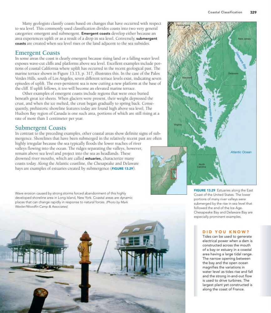
bays are examples of estuaries created by submergence (FIGURE 13.29).
D I D Y O U K N O W ?
Tides can be used to generate
electrical power when a dam is
constructed across the mouth
of a bay or estuary in a coastal
area having a large tidal range.
The narrow opening between
the bay and the open ocean
magnifies the variations in
water level as tides rise and fall
and the strong in-and-out flow
is used to drive turbines. The
largest plant yet constructed is
along the coast of France.
FIGURE 13.29 Estuaries along the East
Coast of the United States. The lower
portions of many river valleys were
submerged by the rise in sea level that
followed the end of the Ice Age.
Chesapeake Bay and Delaware Bay are
especially prominent examples.
Carolina
Virginia
Maryland
Delaware
New Jersey
Pennsylvania
D e la w a r e B a y
Che sap eak e Bay
Atlantic Ocean
Wave erosion caused by strong storms forced abandonment of this highly
developed shoreline area in Long Island, New York. Coastal areas are dynamic
places that can change rapidly in response to natural forces. (Photo by Mark
Wexler/Woodfin Camp & Associates)
329
Coastal Classification
Many geologists classify coasts based on changes that have occurred with respect
to sea level. This commonly used classification divides coasts into two very general
categories: emergent and submergent. Emergent coasts develop either because an
area experiences uplift or as a result of a drop in sea level. Conversely, submergent
coasts are created when sea level rises or the land adjacent to the sea subsides.
Emergent Coasts
In some areas the coast is clearly emergent because rising land or a falling water level
exposes wave-cut cliffs and platforms above sea level. Excellent examples include portions of coastal California where uplift has occurred in the recent geological past. The
marine terrace shown in Figure 13.13, p. 317, illustrates this. In the case of the Palos
Verdes Hills, south of Los Angeles, seven different terrace levels exist, indicating seven
episodes of uplift. The ever-persistent sea is now cutting a new platform at the base of
the cliff. If uplift follows, it too will become an elevated marine terrace.
Other examples of emergent coasts include regions that were once buried
beneath great ice sheets. When glaciers were present, their weight depressed the
crust, and when the ice melted, the crust began gradually to spring back. Consequently, prehistoric shoreline features today are found high above sea level. The
Hudson Bay region of Canada is one such area, portions of which are still rising at a
rate of more than 1 centimeter per year.
Submergent Coasts
In contrast to the preceding examples, other coastal areas show definite signs of submergence. Shorelines that have been submerged in the relatively recent past are often
highly irregular because the sea typically floods the lower reaches of river
valleys flowing into the ocean. The ridges separating the valleys, however,
remain above sea level and project into the sea as headlands. These
drowned river mouths, which are called estuaries, characterize many
coasts today. Along the Atlantic coastline, the Chesapeake and Delaware
bays are examples of estuaries created by submergence (FIGURE 13.29).
D I D Y O U K N O W ?
Tides can be used to generate
electrical power when a dam is
constructed across the mouth
of a bay or estuary in a coastal
area having a large tidal range.
The narrow opening between
the bay and the open ocean
magnifies the variations in
water level as tides rise and fall
and the strong in-and-out flow
is used to drive turbines. The
largest plant yet constructed is
along the coast of France.
FIGURE 13.29 Estuaries along the East
Coast of the United States. The lower
portions of many river valleys were
submerged by the rise in sea level that
followed the end of the Ice Age.
Chesapeake Bay and Delaware Bay are
especially prominent examples.