

327
Hurricanes—The Ultimate Coastal Hazard
storms this powerful are known to have hit the continental United States:
Andrew struck Florida in 1992, Camille pounded Mississippi in 1969,
and a Labor Day hurricane struck the Florida Keys in 1935. Damage
caused by hurricanes can be divided into three categories: (1) storm surge,
(2) wind damage, and (3) inland flooding.
STORM SURGE. Without question, the most devastating damage in the
coastal zone is caused by the storm surge. It not only accounts for a large
share of coastal property losses
but is also responsible for a high
percentage of all hurricane-caused
deaths. A storm surge is a dome
of water 65 to 80 kilometers (40
to 50 miles) wide that sweeps
across the coast near the point
where the eye makes landfall. If all
wave activity were smoothed out,
the storm surge would be the
height of the water above normal
tide level. In addition, tremendous
wave activity is superimposed on
the surge. We can easily imagine
the damage that this surge of
water could inflict on low-lying
coastal areas (see Figure 13.24).
The worst surges occur in places
like the Gulf of Mexico, where the
continental shelf is very shallow and gently sloping. In addition, local
features such as bays and rivers can cause the surge height to double and
increase in speed.
As a hurricane advances toward the coast in the Northern Hemisphere, storm surge is always most intense on the right side of the eye
where winds are blowing toward the shore. In addition, on this side of the
storm, the forward movement of the hurricane also contributes to the
storm surge. In FIGURE 13.28, assume a hurricane with peak winds of 175
kilometers (109 miles) per hour is moving toward the shore at 50 kilometers (31 miles) per hour. In this case, the net wind speed on the right side
of the advancing storm is 225 kilometers (140 miles) per hour. On the left
side, the hurricane’ s winds are blowing opposite the direction of storm
movement, so the net winds are away from the coast at 125 kilometers
(78 miles) per hour. Along the shore facing the left side of the oncoming
hurricane, the water level may actually decrease as the storm makes
landfall.
2/29
3/1
90
80
70
60
50
40
30
20
10
0
1010
1005
1000
995
990
985
980
975
970
965
960
955
Wind speed (knots)
Pressure (millibars)
Mean speed
Pressure
Minimum
pressure 964
on 3 March
12
12
6
PM
6
AM
12
12
6
PM
12
6
PM
6
AM
3/2
Outflow
Eye
A.
B.
Subsiding
air
Surface convergence
Spiral
rain
bands
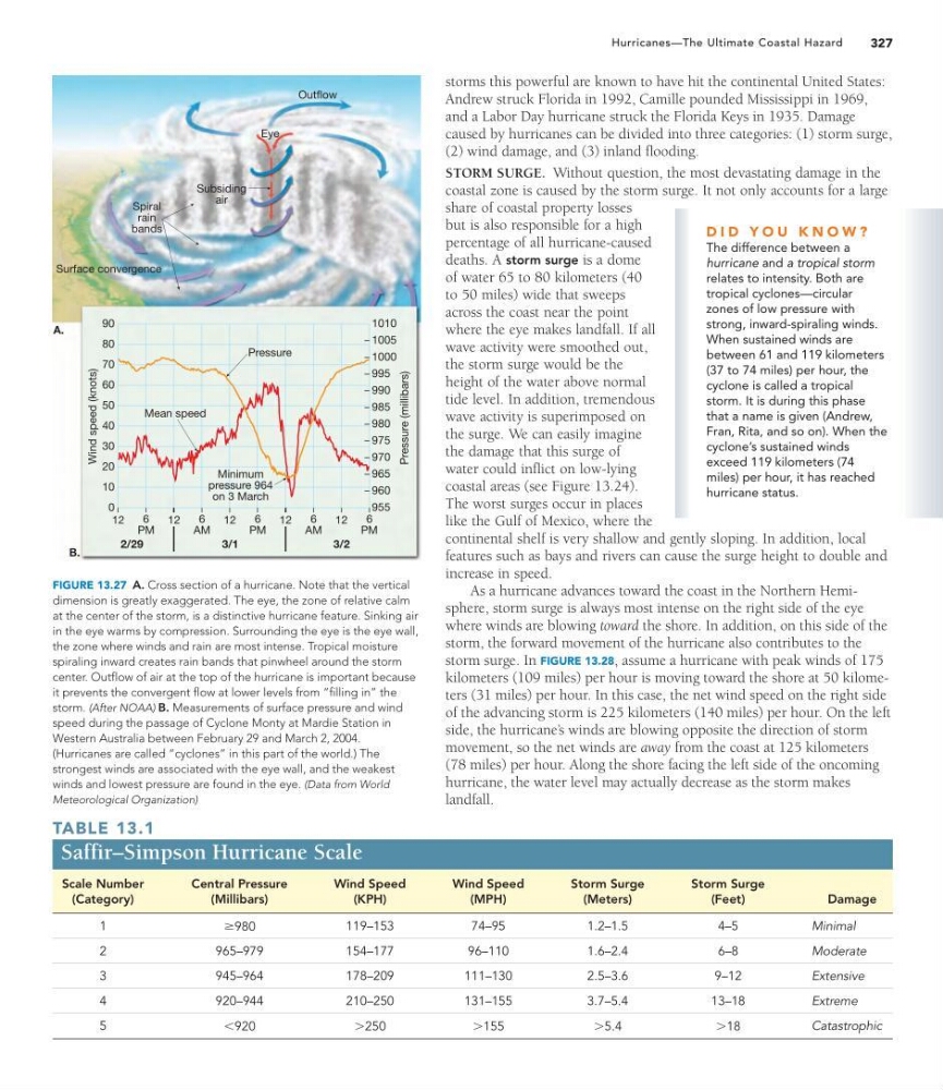
FIGURE 13.27 A. Cross section of a hurricane. Note that the vertical
dimension is greatly exaggerated. The eye, the zone of relative calm
at the center of the storm, is a distinctive hurricane feature. Sinking air
in the eye warms by compression. Surrounding the eye is the eye wall,
the zone where winds and rain are most intense. Tropical moisture
spiraling inward creates rain bands that pinwheel around the storm
center. Outflow of air at the top of the hurricane is important because
it prevents the convergent flow at lower levels from “filling in” the
storm. (After NOAA) B. Measurements of surface pressure and wind
speed during the passage of Cyclone Monty at Mardie Station in
Western Australia between February 29 and March 2, 2004.
(Hurricanes are called “cyclones” in this part of the world.) The
strongest winds are associated with the eye wall, and the weakest
winds and lowest pressure are found in the eye. (Data from World
Meteorological Organization)
TABLE 13.1
Saffir–Simpson Hurricane Scale
Scale Number
(Category)
Central Pressure
(Millibars)
Wind Speed
(KPH)
Wind Speed
(MPH)
Storm Surge
(Meters)
Storm Surge
(Feet)
Damage
1
Ú 980
119–153
74–95
1.2–1.5
4–5
Minimal
2
965–979
154–177
96–110
1.6–2.4
6–8
Moderate
3
945–964
178–209
111–130
2.5–3.6
9–12
Extensive
4
920–944
210–250
131–155
3.7–5.4
13–18
Extreme
5
6 920
7250
7155
75.4
718
Catastrophic
D I D Y O U K N O W ?
The difference between a
hurricane and a tropical storm
relates to intensity. Both are
tropical cyclones—circular
zones of low pressure with
strong, inward-spiraling winds.
When sustained winds are
between 61 and 119 kilometers
(37 to 74 miles) per hour, the
cyclone is called a tropical
storm. It is during this phase
that a name is given (Andrew,
Fran, Rita, and so on). When the
cyclone’s sustained winds
exceed 119 kilometers (74
miles) per hour, it has reached
hurricane status.
Hurricanes—The Ultimate Coastal Hazard
storms this powerful are known to have hit the continental United States:
Andrew struck Florida in 1992, Camille pounded Mississippi in 1969,
and a Labor Day hurricane struck the Florida Keys in 1935. Damage
caused by hurricanes can be divided into three categories: (1) storm surge,
(2) wind damage, and (3) inland flooding.
STORM SURGE. Without question, the most devastating damage in the
coastal zone is caused by the storm surge. It not only accounts for a large
share of coastal property losses
but is also responsible for a high
percentage of all hurricane-caused
deaths. A storm surge is a dome
of water 65 to 80 kilometers (40
to 50 miles) wide that sweeps
across the coast near the point
where the eye makes landfall. If all
wave activity were smoothed out,
the storm surge would be the
height of the water above normal
tide level. In addition, tremendous
wave activity is superimposed on
the surge. We can easily imagine
the damage that this surge of
water could inflict on low-lying
coastal areas (see Figure 13.24).
The worst surges occur in places
like the Gulf of Mexico, where the
continental shelf is very shallow and gently sloping. In addition, local
features such as bays and rivers can cause the surge height to double and
increase in speed.
As a hurricane advances toward the coast in the Northern Hemisphere, storm surge is always most intense on the right side of the eye
where winds are blowing toward the shore. In addition, on this side of the
storm, the forward movement of the hurricane also contributes to the
storm surge. In FIGURE 13.28, assume a hurricane with peak winds of 175
kilometers (109 miles) per hour is moving toward the shore at 50 kilometers (31 miles) per hour. In this case, the net wind speed on the right side
of the advancing storm is 225 kilometers (140 miles) per hour. On the left
side, the hurricane’ s winds are blowing opposite the direction of storm
movement, so the net winds are away from the coast at 125 kilometers
(78 miles) per hour. Along the shore facing the left side of the oncoming
hurricane, the water level may actually decrease as the storm makes
landfall.
2/29
3/1
90
80
70
60
50
40
30
20
10
0
1010
1005
1000
995
990
985
980
975
970
965
960
955
Wind speed (knots)
Pressure (millibars)
Mean speed
Pressure
Minimum
pressure 964
on 3 March
12
12
6
PM
6
AM
12
12
6
PM
12
6
PM
6
AM
3/2
Outflow
Eye
A.
B.
Subsiding
air
Surface convergence
Spiral
rain
bands
FIGURE 13.27 A. Cross section of a hurricane. Note that the vertical
dimension is greatly exaggerated. The eye, the zone of relative calm
at the center of the storm, is a distinctive hurricane feature. Sinking air
in the eye warms by compression. Surrounding the eye is the eye wall,
the zone where winds and rain are most intense. Tropical moisture
spiraling inward creates rain bands that pinwheel around the storm
center. Outflow of air at the top of the hurricane is important because
it prevents the convergent flow at lower levels from “filling in” the
storm. (After NOAA) B. Measurements of surface pressure and wind
speed during the passage of Cyclone Monty at Mardie Station in
Western Australia between February 29 and March 2, 2004.
(Hurricanes are called “cyclones” in this part of the world.) The
strongest winds are associated with the eye wall, and the weakest
winds and lowest pressure are found in the eye. (Data from World
Meteorological Organization)
TABLE 13.1
Saffir–Simpson Hurricane Scale
Scale Number
(Category)
Central Pressure
(Millibars)
Wind Speed
(KPH)
Wind Speed
(MPH)
Storm Surge
(Meters)
Storm Surge
(Feet)
Damage
1
Ú 980
119–153
74–95
1.2–1.5
4–5
Minimal
2
965–979
154–177
96–110
1.6–2.4
6–8
Moderate
3
945–964
178–209
111–130
2.5–3.6
9–12
Extensive
4
920–944
210–250
131–155
3.7–5.4
13–18
Extreme
5
6 920
7250
7155
75.4
718
Catastrophic
D I D Y O U K N O W ?
The difference between a
hurricane and a tropical storm
relates to intensity. Both are
tropical cyclones—circular
zones of low pressure with
strong, inward-spiraling winds.
When sustained winds are
between 61 and 119 kilometers
(37 to 74 miles) per hour, the
cyclone is called a tropical
storm. It is during this phase
that a name is given (Andrew,
Fran, Rita, and so on). When the
cyclone’s sustained winds
exceed 119 kilometers (74
miles) per hour, it has reached
hurricane status.