

CHAPTER 13 Shorelines
326
Although many tropical disturbances develop each year, only a
few reach hurricane status. By international agreement, a hurricane
has wind speeds in excess of 119 kilometers (74 miles) per hour
and a rotary circulation. Mature hurricanes average 600 kilometers
(375 miles) in diameter and often extend 12,000 meters (40,000
feet) above the ocean surface. The lowest pressures ever recorded
in the Western Hemisphere are associated with these storms.
An extremely rapid change in air pressure generates the strong,
inward-spiraling winds of a hurricane (FIGURE 13.27). As the air
rushes toward the center of the storm, its velocity increases. This
occurs for the same reason that skaters with their arms extended
spin faster as they pull their arms in close to their bodies.
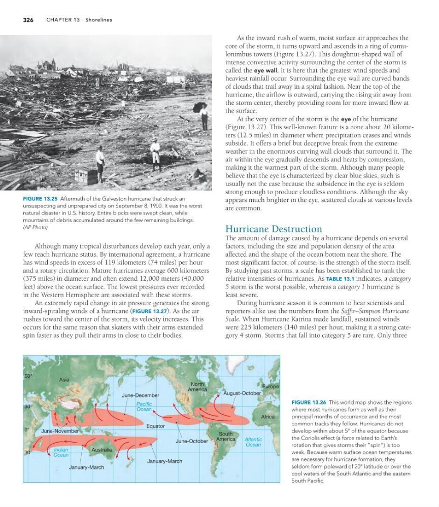
FIGURE 13.25 Aftermath of the Galveston hurricane that struck an
unsuspecting and unprepared city on September 8, 1900. It was the worst
natural disaster in U.S. history. Entire blocks were swept clean, while
mountains of debris accumulated around the few remaining buildings.
(AP Photo)
0°
30°
60°
January-March
June-October
August-October
Equator
January-March
June-November
June-December
Asia
Australia
North
America
South
America
Europe
Atlantic
Ocean
Pacific
Ocean
Indian
Ocean
Africa
30°
FIGURE 13.26 This world map shows the regions
where most hurricanes form as well as their
principal months of occurrence and the most
common tracks they follow. Hurricanes do not
develop within about 5° of the equator because
the Coriolis effect (a force related to Earth’s
rotation that gives storms their “spin”) is too
weak. Because warm surface ocean temperatures
are necessary for hurricane formation, they
seldom form poleward of 20° latitude or over the
cool waters of the South Atlantic and the eastern
South Pacific.
As the inward rush of warm, moist surface air approaches the
core of the storm, it turns upward and ascends in a ring of cumulonimbus towers (Figure 13.27). This doughnut-shaped wall of
intense convective activity surrounding the center of the storm is
called the eye wall. It is here that the greatest wind speeds and
heaviest rainfall occur. Surrounding the eye wall are curved bands
of clouds that trail away in a spiral fashion. Near the top of the
hurricane, the airflow is outward, carrying the rising air away from
the storm center, thereby providing room for more inward flow at
the surface.
At the very center of the storm is the eye of the hurricane
(Figure 13.27). This well-known feature is a zone about 20 kilometers (12.5 miles) in diameter where precipitation ceases and winds
subside. It offers a brief but deceptive break from the extreme
weather in the enormous curving wall clouds that surround it. The
air within the eye gradually descends and heats by compression,
making it the warmest part of the storm. Although many people
believe that the eye is characterized by clear blue skies, such is
usually not the case because the subsidence in the eye is seldom
strong enough to produce cloudless conditions. Although the sky
appears much brighter in the eye, scattered clouds at various levels
are common.
Hurricane Destruction
The amount of damage caused by a hurricane depends on several
factors, including the size and population density of the area
affected and the shape of the ocean bottom near the shore. The
most significant factor, of course, is the strength of the storm itself.
By studying past storms, a scale has been established to rank the
relative intensities of hurricanes. As TABLE 13.1 indicates, a category
5 storm is the worst possible, whereas a category 1 hurricane is
least severe.
During hurricane season it is common to hear scientists and
reporters alike use the numbers from the Saffir–Simpson Hurricane
Scale. When Hurricane Katrina made landfall, sustained winds
were 225 kilometers (140 miles) per hour, making it a strong category 4 storm. Storms that fall into category 5 are rare. Only three
326
Although many tropical disturbances develop each year, only a
few reach hurricane status. By international agreement, a hurricane
has wind speeds in excess of 119 kilometers (74 miles) per hour
and a rotary circulation. Mature hurricanes average 600 kilometers
(375 miles) in diameter and often extend 12,000 meters (40,000
feet) above the ocean surface. The lowest pressures ever recorded
in the Western Hemisphere are associated with these storms.
An extremely rapid change in air pressure generates the strong,
inward-spiraling winds of a hurricane (FIGURE 13.27). As the air
rushes toward the center of the storm, its velocity increases. This
occurs for the same reason that skaters with their arms extended
spin faster as they pull their arms in close to their bodies.
FIGURE 13.25 Aftermath of the Galveston hurricane that struck an
unsuspecting and unprepared city on September 8, 1900. It was the worst
natural disaster in U.S. history. Entire blocks were swept clean, while
mountains of debris accumulated around the few remaining buildings.
(AP Photo)
0°
30°
60°
January-March
June-October
August-October
Equator
January-March
June-November
June-December
Asia
Australia
North
America
South
America
Europe
Atlantic
Ocean
Pacific
Ocean
Indian
Ocean
Africa
30°
FIGURE 13.26 This world map shows the regions
where most hurricanes form as well as their
principal months of occurrence and the most
common tracks they follow. Hurricanes do not
develop within about 5° of the equator because
the Coriolis effect (a force related to Earth’s
rotation that gives storms their “spin”) is too
weak. Because warm surface ocean temperatures
are necessary for hurricane formation, they
seldom form poleward of 20° latitude or over the
cool waters of the South Atlantic and the eastern
South Pacific.
As the inward rush of warm, moist surface air approaches the
core of the storm, it turns upward and ascends in a ring of cumulonimbus towers (Figure 13.27). This doughnut-shaped wall of
intense convective activity surrounding the center of the storm is
called the eye wall. It is here that the greatest wind speeds and
heaviest rainfall occur. Surrounding the eye wall are curved bands
of clouds that trail away in a spiral fashion. Near the top of the
hurricane, the airflow is outward, carrying the rising air away from
the storm center, thereby providing room for more inward flow at
the surface.
At the very center of the storm is the eye of the hurricane
(Figure 13.27). This well-known feature is a zone about 20 kilometers (12.5 miles) in diameter where precipitation ceases and winds
subside. It offers a brief but deceptive break from the extreme
weather in the enormous curving wall clouds that surround it. The
air within the eye gradually descends and heats by compression,
making it the warmest part of the storm. Although many people
believe that the eye is characterized by clear blue skies, such is
usually not the case because the subsidence in the eye is seldom
strong enough to produce cloudless conditions. Although the sky
appears much brighter in the eye, scattered clouds at various levels
are common.
Hurricane Destruction
The amount of damage caused by a hurricane depends on several
factors, including the size and population density of the area
affected and the shape of the ocean bottom near the shore. The
most significant factor, of course, is the strength of the storm itself.
By studying past storms, a scale has been established to rank the
relative intensities of hurricanes. As TABLE 13.1 indicates, a category
5 storm is the worst possible, whereas a category 1 hurricane is
least severe.
During hurricane season it is common to hear scientists and
reporters alike use the numbers from the Saffir–Simpson Hurricane
Scale. When Hurricane Katrina made landfall, sustained winds
were 225 kilometers (140 miles) per hour, making it a strong category 4 storm. Storms that fall into category 5 are rare. Only three