

325
Hurricanes—The Ultimate Coastal Hazard
A.
B.
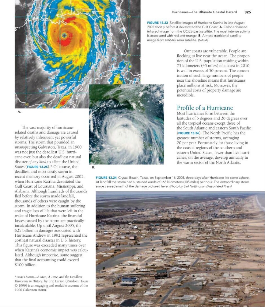
FIGURE 13.23 Satellite images of Hurricane Katrina in late August
2005 shortly before it devastated the Gulf Coast. A. Color-enhanced
infrared image from the GOES-East satellite. The most intense activity
is associated with red and orange. B. A more traditional satellite
image from NASA’s Terra satellite. (NASA)
The vast majority of hurricanerelated deaths and damage are caused
by relatively infrequent yet powerful
storms. The storm that pounded an
unsuspecting Galveston, Texas, in 1900
was not just the deadliest U.S. hurricane ever, but also the deadliest natural
disaster of any kind to affect the United
States (FIGURE 13.25).* Of course, the
deadliest and most costly storm in
recent memory occurred in August 2005,
when Hurricane Katrina devastated the
Gulf Coast of Louisiana, Mississippi, and
Alabama. Although hundreds of thousands
fled before the storm made landfall,
thousands of others were caught by the
storm. In addition to the human suffering
and tragic loss of life that were left in the
wake of Hurricane Katrina, the financial
losses caused by the storm are practically
incalculable. Up until August 2005, the
$25 billion in damages associated with
Hurricane Andrew in 1992 represented the
costliest natural disaster in U.S. history.
This figure was exceeded many times over
when Katrina’ s economic impact was calculated. Although imprecise, some suggest
that the final accounting could exceed
$100 billion.
*Isaac’s Storm—A Man, A Time, and the Deadliest
Hurricane in History, by Eric Larson (Random House
© 1999) is an engaging and readable account of the
1900 Galveston storm.
FIGURE 13.24 Crystal Beach, Texas, on September 16, 2008, three days after Hurricane Ike came ashore.
At landfall the storm had sustained winds of 165 kilometers (105 miles) per hour. The extraordinary storm
surge caused much of the damage pictured here. (Photo by Earl Nottingham/Associated Press)
Our coasts are vulnerable. People are
flocking to live near the ocean. The proportion of the U.S. population residing within
75 kilometers (45 miles) of a coast in 2010
is well in excess of 50 percent. The concentration of such large numbers of people
near the shoreline means that hurricanes
place millions at risk. Moreover, the
potential costs of property damage are
incredible.
Profile of a Hurricane
Most hurricanes form between the
latitudes of 5 degrees and 20 degrees over
all the tropical oceans except those of
the South Atlantic and eastern South Pacific
(FIGURE 13.26). The North Pacific has the
greatest number of storms, averaging
20 per year. Fortunately for those living in
the coastal regions of the southern and
eastern United States, fewer than five hurricanes, on the average, develop annually in
the warm sector of the North Atlantic.
Hurricanes—The Ultimate Coastal Hazard
A.
B.
FIGURE 13.23 Satellite images of Hurricane Katrina in late August
2005 shortly before it devastated the Gulf Coast. A. Color-enhanced
infrared image from the GOES-East satellite. The most intense activity
is associated with red and orange. B. A more traditional satellite
image from NASA’s Terra satellite. (NASA)
The vast majority of hurricanerelated deaths and damage are caused
by relatively infrequent yet powerful
storms. The storm that pounded an
unsuspecting Galveston, Texas, in 1900
was not just the deadliest U.S. hurricane ever, but also the deadliest natural
disaster of any kind to affect the United
States (FIGURE 13.25).* Of course, the
deadliest and most costly storm in
recent memory occurred in August 2005,
when Hurricane Katrina devastated the
Gulf Coast of Louisiana, Mississippi, and
Alabama. Although hundreds of thousands
fled before the storm made landfall,
thousands of others were caught by the
storm. In addition to the human suffering
and tragic loss of life that were left in the
wake of Hurricane Katrina, the financial
losses caused by the storm are practically
incalculable. Up until August 2005, the
$25 billion in damages associated with
Hurricane Andrew in 1992 represented the
costliest natural disaster in U.S. history.
This figure was exceeded many times over
when Katrina’ s economic impact was calculated. Although imprecise, some suggest
that the final accounting could exceed
$100 billion.
*Isaac’s Storm—A Man, A Time, and the Deadliest
Hurricane in History, by Eric Larson (Random House
© 1999) is an engaging and readable account of the
1900 Galveston storm.
FIGURE 13.24 Crystal Beach, Texas, on September 16, 2008, three days after Hurricane Ike came ashore.
At landfall the storm had sustained winds of 165 kilometers (105 miles) per hour. The extraordinary storm
surge caused much of the damage pictured here. (Photo by Earl Nottingham/Associated Press)
Our coasts are vulnerable. People are
flocking to live near the ocean. The proportion of the U.S. population residing within
75 kilometers (45 miles) of a coast in 2010
is well in excess of 50 percent. The concentration of such large numbers of people
near the shoreline means that hurricanes
place millions at risk. Moreover, the
potential costs of property damage are
incredible.
Profile of a Hurricane
Most hurricanes form between the
latitudes of 5 degrees and 20 degrees over
all the tropical oceans except those of
the South Atlantic and eastern South Pacific
(FIGURE 13.26). The North Pacific has the
greatest number of storms, averaging
20 per year. Fortunately for those living in
the coastal regions of the southern and
eastern United States, fewer than five hurricanes, on the average, develop annually in
the warm sector of the North Atlantic.