

Waves travel
at original speed
in deep water
Beach
deposits
A.
B.
Waves “feel bottom”
and slow down
in surf zone
Result: waves bend
so that they strike the
shore more directly
Shoreline
Headland
Surf
zone
Land
Surf
zone
315
Sand Movement on the Beach
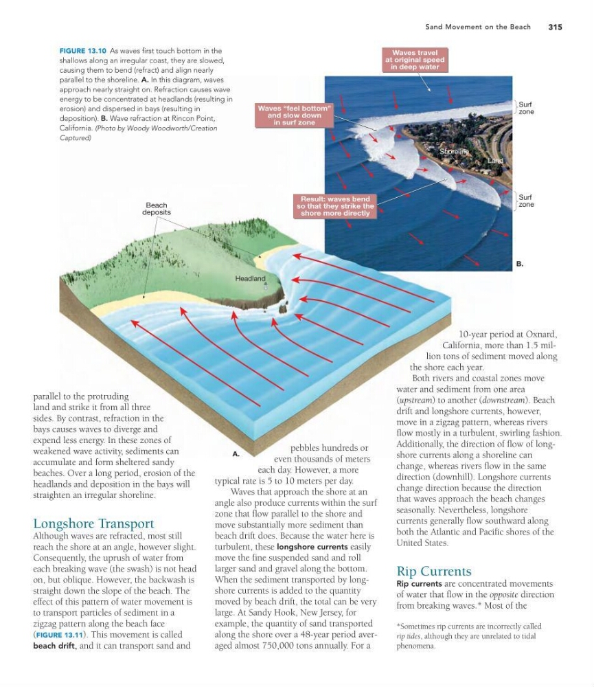
parallel to the protruding
land and strike it from all three
sides. By contrast, refraction in the
bays causes waves to diverge and
expend less energy. In these zones of
weakened wave activity, sediments can
accumulate and form sheltered sandy
beaches. Over a long period, erosion of the
headlands and deposition in the bays will
straighten an irregular shoreline.
Longshore Transport
Although waves are refracted, most still
reach the shore at an angle, however slight.
Consequently, the uprush of water from
each breaking wave (the swash) is not head
on, but oblique. However, the backwash is
straight down the slope of the beach. The
effect of this pattern of water movement is
to transport particles of sediment in a
zigzag pattern along the beach face
(FIGURE 13.11). This movement is called
beach drift, and it can transport sand and
pebbles hundreds or
even thousands of meters
each day. However, a more
typical rate is 5 to 10 meters per day.
Waves that approach the shore at an
angle also produce currents within the surf
zone that flow parallel to the shore and
move substantially more sediment than
beach drift does. Because the water here is
turbulent, these longshore currents easily
move the fine suspended sand and roll
larger sand and gravel along the bottom.
When the sediment transported by longshore currents is added to the quantity
moved by beach drift, the total can be very
large. At Sandy Hook, New Jersey, for
example, the quantity of sand transported
along the shore over a 48-year period averaged almost 750,000 tons annually. For a
10-year period at Oxnard,
California, more than 1.5 million tons of sediment moved along
the shore each year.
Both rivers and coastal zones move
water and sediment from one area
(upstream) to another (downstream). Beach
drift and longshore currents, however,
move in a zigzag pattern, whereas rivers
flow mostly in a turbulent, swirling fashion.
Additionally, the direction of flow of longshore currents along a shoreline can
change, whereas rivers flow in the same
direction (downhill). Longshore currents
change direction because the direction
that waves approach the beach changes
seasonally. Nevertheless, longshore
currents generally flow southward along
both the Atlantic and Pacific shores of the
United States.
Rip Currents
Rip currents are concentrated movements
of water that flow in the opposite direction
from breaking waves.* Most of the
FIGURE 13.10 As waves first touch bottom in the
shallows along an irregular coast, they are slowed,
causing them to bend (refract) and align nearly
parallel to the shoreline. A. In this diagram, waves
approach nearly straight on. Refraction causes wave
energy to be concentrated at headlands (resulting in
erosion) and dispersed in bays (resulting in
deposition). B. Wave refraction at Rincon Point,
California. (Photo by Woody Woodworth/Creation
Captured)
*Sometimes rip currents are incorrectly called
rip tides, although they are unrelated to tidal
phenomena.
at original speed
in deep water
Beach
deposits
A.
B.
Waves “feel bottom”
and slow down
in surf zone
Result: waves bend
so that they strike the
shore more directly
Shoreline
Headland
Surf
zone
Land
Surf
zone
315
Sand Movement on the Beach
parallel to the protruding
land and strike it from all three
sides. By contrast, refraction in the
bays causes waves to diverge and
expend less energy. In these zones of
weakened wave activity, sediments can
accumulate and form sheltered sandy
beaches. Over a long period, erosion of the
headlands and deposition in the bays will
straighten an irregular shoreline.
Longshore Transport
Although waves are refracted, most still
reach the shore at an angle, however slight.
Consequently, the uprush of water from
each breaking wave (the swash) is not head
on, but oblique. However, the backwash is
straight down the slope of the beach. The
effect of this pattern of water movement is
to transport particles of sediment in a
zigzag pattern along the beach face
(FIGURE 13.11). This movement is called
beach drift, and it can transport sand and
pebbles hundreds or
even thousands of meters
each day. However, a more
typical rate is 5 to 10 meters per day.
Waves that approach the shore at an
angle also produce currents within the surf
zone that flow parallel to the shore and
move substantially more sediment than
beach drift does. Because the water here is
turbulent, these longshore currents easily
move the fine suspended sand and roll
larger sand and gravel along the bottom.
When the sediment transported by longshore currents is added to the quantity
moved by beach drift, the total can be very
large. At Sandy Hook, New Jersey, for
example, the quantity of sand transported
along the shore over a 48-year period averaged almost 750,000 tons annually. For a
10-year period at Oxnard,
California, more than 1.5 million tons of sediment moved along
the shore each year.
Both rivers and coastal zones move
water and sediment from one area
(upstream) to another (downstream). Beach
drift and longshore currents, however,
move in a zigzag pattern, whereas rivers
flow mostly in a turbulent, swirling fashion.
Additionally, the direction of flow of longshore currents along a shoreline can
change, whereas rivers flow in the same
direction (downhill). Longshore currents
change direction because the direction
that waves approach the beach changes
seasonally. Nevertheless, longshore
currents generally flow southward along
both the Atlantic and Pacific shores of the
United States.
Rip Currents
Rip currents are concentrated movements
of water that flow in the opposite direction
from breaking waves.* Most of the
FIGURE 13.10 As waves first touch bottom in the
shallows along an irregular coast, they are slowed,
causing them to bend (refract) and align nearly
parallel to the shoreline. A. In this diagram, waves
approach nearly straight on. Refraction causes wave
energy to be concentrated at headlands (resulting in
erosion) and dispersed in bays (resulting in
deposition). B. Wave refraction at Rincon Point,
California. (Photo by Woody Woodworth/Creation
Captured)
*Sometimes rip currents are incorrectly called
rip tides, although they are unrelated to tidal
phenomena.