

A.
B.
Blowout
297
Wind Erosion
Compared to running water and glaciers,
wind is a relatively insignificant erosional
agent. Recall that even in deserts, most
erosion is performed by intermittent
running water, not by the wind. Wind
erosion is more effective in arid lands
than in humid areas because in humid
regions moisture binds particles together
and vegetation anchors the soil. For
wind to be effective, dryness and
scanty vegetation are important
prerequisites.
When such circumstances exist, wind
may pick up, transport, and deposit great
quantities of fine sediment. During the
1930s, parts of the Great Plains experienced great dust storms. The plowing
under of the natural vegetative cover for
farming, followed by severe drought, made
the land ripe for wind erosion and led to
the areas being labeled the Dust Bowl.
There is more about this environmental
disaster in Chapter 5.
Deflation and Blowouts
One way that wind erodes is by deflation,
the lifting and removal of loose material.
Although the effects of deflation are sometimes difficult to notice because the entire
surface is being lowered at the same time,
they can be significant. In portions of
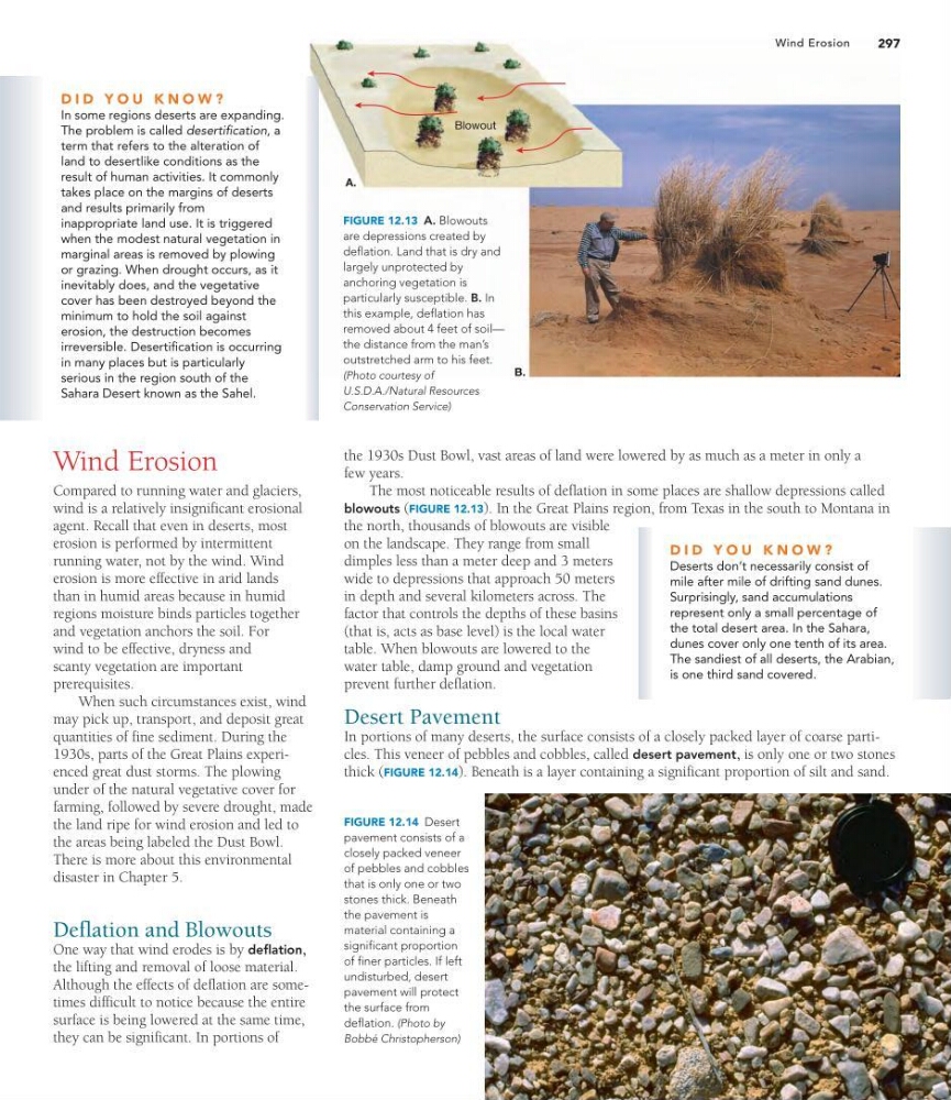
FIGURE 12.13 A. Blowouts
are depressions created by
deflation. Land that is dry and
largely unprotected by
anchoring vegetation is
particularly susceptible. B. In
this example, deflation has
removed about 4 feet of soil—
the distance from the man’s
outstretched arm to his feet.
(Photo courtesy of
U.S.D.A./Natural Resources
Conservation Service)
Wind Erosion
FIGURE 12.14 Desert
pavement consists of a
closely packed veneer
of pebbles and cobbles
that is only one or two
stones thick. Beneath
the pavement is
material containing a
significant proportion
of finer particles. If left
undisturbed, desert
pavement will protect
the surface from
deflation. (Photo by
Bobbé Christopherson)
the 1930s Dust Bowl, vast areas of land were lowered by as much as a meter in only a
few years.
The most noticeable results of deflation in some places are shallow depressions called
blowouts (FIGURE 12.13). In the Great Plains region, from Texas in the south to Montana in
the north, thousands of blowouts are visible
on the landscape. They range from small
dimples less than a meter deep and 3 meters
wide to depressions that approach 50 meters
in depth and several kilometers across. The
factor that controls the depths of these basins
(that is, acts as base level) is the local water
table. When blowouts are lowered to the
water table, damp ground and vegetation
prevent further deflation.
Desert Pavement
In portions of many deserts, the surface consists of a closely packed layer of coarse particles. This veneer of pebbles and cobbles, called desert pavement, is only one or two stones
thick (FIGURE 12.14). Beneath is a layer containing a significant proportion of silt and sand.
D I D Y O U K N O W ?
Deserts don’t necessarily consist of
mile after mile of drifting sand dunes.
Surprisingly, sand accumulations
represent only a small percentage of
the total desert area. In the Sahara,
dunes cover only one tenth of its area.
The sandiest of all deserts, the Arabian,
is one third sand covered.
D I D Y O U K N O W ?
In some regions deserts are expanding.
The problem is called desertification, a
term that refers to the alteration of
land to desertlike conditions as the
result of human activities. It commonly
takes place on the margins of deserts
and results primarily from
inappropriate land use. It is triggered
when the modest natural vegetation in
marginal areas is removed by plowing
or grazing. When drought occurs, as it
inevitably does, and the vegetative
cover has been destroyed beyond the
minimum to hold the soil against
erosion, the destruction becomes
irreversible. Desertification is occurring
in many places but is particularly
serious in the region south of the
Sahara Desert known as the Sahel.
B.
Blowout
297
Wind Erosion
Compared to running water and glaciers,
wind is a relatively insignificant erosional
agent. Recall that even in deserts, most
erosion is performed by intermittent
running water, not by the wind. Wind
erosion is more effective in arid lands
than in humid areas because in humid
regions moisture binds particles together
and vegetation anchors the soil. For
wind to be effective, dryness and
scanty vegetation are important
prerequisites.
When such circumstances exist, wind
may pick up, transport, and deposit great
quantities of fine sediment. During the
1930s, parts of the Great Plains experienced great dust storms. The plowing
under of the natural vegetative cover for
farming, followed by severe drought, made
the land ripe for wind erosion and led to
the areas being labeled the Dust Bowl.
There is more about this environmental
disaster in Chapter 5.
Deflation and Blowouts
One way that wind erodes is by deflation,
the lifting and removal of loose material.
Although the effects of deflation are sometimes difficult to notice because the entire
surface is being lowered at the same time,
they can be significant. In portions of
FIGURE 12.13 A. Blowouts
are depressions created by
deflation. Land that is dry and
largely unprotected by
anchoring vegetation is
particularly susceptible. B. In
this example, deflation has
removed about 4 feet of soil—
the distance from the man’s
outstretched arm to his feet.
(Photo courtesy of
U.S.D.A./Natural Resources
Conservation Service)
Wind Erosion
FIGURE 12.14 Desert
pavement consists of a
closely packed veneer
of pebbles and cobbles
that is only one or two
stones thick. Beneath
the pavement is
material containing a
significant proportion
of finer particles. If left
undisturbed, desert
pavement will protect
the surface from
deflation. (Photo by
Bobbé Christopherson)
the 1930s Dust Bowl, vast areas of land were lowered by as much as a meter in only a
few years.
The most noticeable results of deflation in some places are shallow depressions called
blowouts (FIGURE 12.13). In the Great Plains region, from Texas in the south to Montana in
the north, thousands of blowouts are visible
on the landscape. They range from small
dimples less than a meter deep and 3 meters
wide to depressions that approach 50 meters
in depth and several kilometers across. The
factor that controls the depths of these basins
(that is, acts as base level) is the local water
table. When blowouts are lowered to the
water table, damp ground and vegetation
prevent further deflation.
Desert Pavement
In portions of many deserts, the surface consists of a closely packed layer of coarse particles. This veneer of pebbles and cobbles, called desert pavement, is only one or two stones
thick (FIGURE 12.14). Beneath is a layer containing a significant proportion of silt and sand.
D I D Y O U K N O W ?
Deserts don’t necessarily consist of
mile after mile of drifting sand dunes.
Surprisingly, sand accumulations
represent only a small percentage of
the total desert area. In the Sahara,
dunes cover only one tenth of its area.
The sandiest of all deserts, the Arabian,
is one third sand covered.
D I D Y O U K N O W ?
In some regions deserts are expanding.
The problem is called desertification, a
term that refers to the alteration of
land to desertlike conditions as the
result of human activities. It commonly
takes place on the margins of deserts
and results primarily from
inappropriate land use. It is triggered
when the modest natural vegetation in
marginal areas is removed by plowing
or grazing. When drought occurs, as it
inevitably does, and the vegetative
cover has been destroyed beyond the
minimum to hold the soil against
erosion, the destruction becomes
irreversible. Desertification is occurring
in many places but is particularly
serious in the region south of the
Sahara Desert known as the Sahel.