

Basin
and
Range
A.
Playa lake
Alluvial fans
B.
Playa
Bajada
C.
Inselberg
T
I
M
E
CHAPTER 12 Deserts and Wind
294
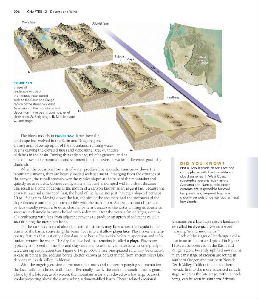
The block models in FIGURE 12.9 depict how the
landscape has evolved in the Basin and Range region.
During and following uplift of the mountains, running water
begins carving the elevated mass and depositing large quantities
of debris in the basin. During this early stage, relief is greatest, and as
erosion lowers the mountains and sediment fills the basins, elevation differences gradually
diminish.
When the occasional torrents of water produced by sporadic rains move down the
mountain canyons, they are heavily loaded with sediment. Emerging from the confines of
the canyon, the runoff spreads over the gentler slopes at the base of the mountains and
quickly loses velocity. Consequently, most of its load is dumped within a short distance.
The result is a cone of debris at the mouth of a canyon known as an alluvial fan. Because the
coarsest material is dropped first, the head of the fan is steepest, having a slope of perhaps
10 to 15 degrees. Moving down the fan, the size of the sediment and the steepness of the
slope decrease and merge imperceptibly with the basin floor. An examination of the fan’ s
surface usually reveals a braided channel pattern because of the water shifting its course as
successive channels became choked with sediment. Over the years a fan enlarges, eventually coalescing with fans from adjacent canyons to produce an apron of sediment called a
bajada along the mountain front.
On the rare occasions of abundant rainfall, streams may flow across the bajada to the
center of the basin, converting the basin floor into a shallow playa lake. Playa lakes are temporary features that last only a few days or at best a few weeks before evaporation and infiltration remove the water. The dry, flat lake bed that remains is called a playa. Playas are
typically composed of fine silts and clays and are occasionally encrusted with salts precipitated during evaporation (see Figure 6.14, p. 160). These precipitated salts may be unusual.
A case in point is the sodium borate (better known as borax) mined from ancient playa lake
deposits in Death Valley, California.
With the ongoing erosion of the mountain mass and the accompanying sedimentation,
the local relief continues to diminish. Eventually, nearly the entire mountain mass is gone.
Thus, by the late stages of erosion, the mountain areas are reduced to a few large bedrock
knobs projecting above the surrounding sediment-filled basin. These isolated erosional
FIGURE 12.9
Stages of
landscape evolution
in a mountainous desert
such as the Basin and Range
region of the American West.
As erosion of the mountains and
deposition in the basins continue, relief
diminishes. A. Early stage. B. Middle stage.
C. Late stage.
D I D Y O U K N O W ?
Not all low-latitude deserts are hot,
sunny places with low humidity and
cloudless skies. In West Coast
subtropical deserts, such as the
Atacama and Namib, cold ocean
currents are responsible for cool
temperatures, frequent fogs, and
gloomy periods of dense (but rainless)
low clouds.
remnants on a late-stage desert landscape
are called inselbergs, a German word
meaning “island mountains.”
Each of the stages of landscape evolution in an arid climate depicted in Figure
12.9 can be observed in the Basin and
Range region. Recently uplifted mountains
in an early stage of erosion are found in
southern Oregon and northern Nevada.
Death Valley, California, and southern
Nevada fit into the more advanced middle
stage, whereas the late stage, with its inselbergs, can be seen in southern Arizona.
and
Range
A.
Playa lake
Alluvial fans
B.
Playa
Bajada
C.
Inselberg
T
I
M
E
CHAPTER 12 Deserts and Wind
294
The block models in FIGURE 12.9 depict how the
landscape has evolved in the Basin and Range region.
During and following uplift of the mountains, running water
begins carving the elevated mass and depositing large quantities
of debris in the basin. During this early stage, relief is greatest, and as
erosion lowers the mountains and sediment fills the basins, elevation differences gradually
diminish.
When the occasional torrents of water produced by sporadic rains move down the
mountain canyons, they are heavily loaded with sediment. Emerging from the confines of
the canyon, the runoff spreads over the gentler slopes at the base of the mountains and
quickly loses velocity. Consequently, most of its load is dumped within a short distance.
The result is a cone of debris at the mouth of a canyon known as an alluvial fan. Because the
coarsest material is dropped first, the head of the fan is steepest, having a slope of perhaps
10 to 15 degrees. Moving down the fan, the size of the sediment and the steepness of the
slope decrease and merge imperceptibly with the basin floor. An examination of the fan’ s
surface usually reveals a braided channel pattern because of the water shifting its course as
successive channels became choked with sediment. Over the years a fan enlarges, eventually coalescing with fans from adjacent canyons to produce an apron of sediment called a
bajada along the mountain front.
On the rare occasions of abundant rainfall, streams may flow across the bajada to the
center of the basin, converting the basin floor into a shallow playa lake. Playa lakes are temporary features that last only a few days or at best a few weeks before evaporation and infiltration remove the water. The dry, flat lake bed that remains is called a playa. Playas are
typically composed of fine silts and clays and are occasionally encrusted with salts precipitated during evaporation (see Figure 6.14, p. 160). These precipitated salts may be unusual.
A case in point is the sodium borate (better known as borax) mined from ancient playa lake
deposits in Death Valley, California.
With the ongoing erosion of the mountain mass and the accompanying sedimentation,
the local relief continues to diminish. Eventually, nearly the entire mountain mass is gone.
Thus, by the late stages of erosion, the mountain areas are reduced to a few large bedrock
knobs projecting above the surrounding sediment-filled basin. These isolated erosional
FIGURE 12.9
Stages of
landscape evolution
in a mountainous desert
such as the Basin and Range
region of the American West.
As erosion of the mountains and
deposition in the basins continue, relief
diminishes. A. Early stage. B. Middle stage.
C. Late stage.
D I D Y O U K N O W ?
Not all low-latitude deserts are hot,
sunny places with low humidity and
cloudless skies. In West Coast
subtropical deserts, such as the
Atacama and Namib, cold ocean
currents are responsible for cool
temperatures, frequent fogs, and
gloomy periods of dense (but rainless)
low clouds.
remnants on a late-stage desert landscape
are called inselbergs, a German word
meaning “island mountains.”
Each of the stages of landscape evolution in an arid climate depicted in Figure
12.9 can be observed in the Basin and
Range region. Recently uplifted mountains
in an early stage of erosion are found in
southern Oregon and northern Nevada.
Death Valley, California, and southern
Nevada fit into the more advanced middle
stage, whereas the late stage, with its inselbergs, can be seen in southern Arizona.