

aridity
losses occurring as the stream crosses the desert. For example, after
the Nile leaves its headwaters in the lakes and mountains of central
Africa, it traverses almost 3000 kilometers (1900 miles) of the
Sahara without a single tributary. By contrast, in humid regions the
discharge of a river increases as it flows downstream because tributaries and groundwater contribute additional water along the way.
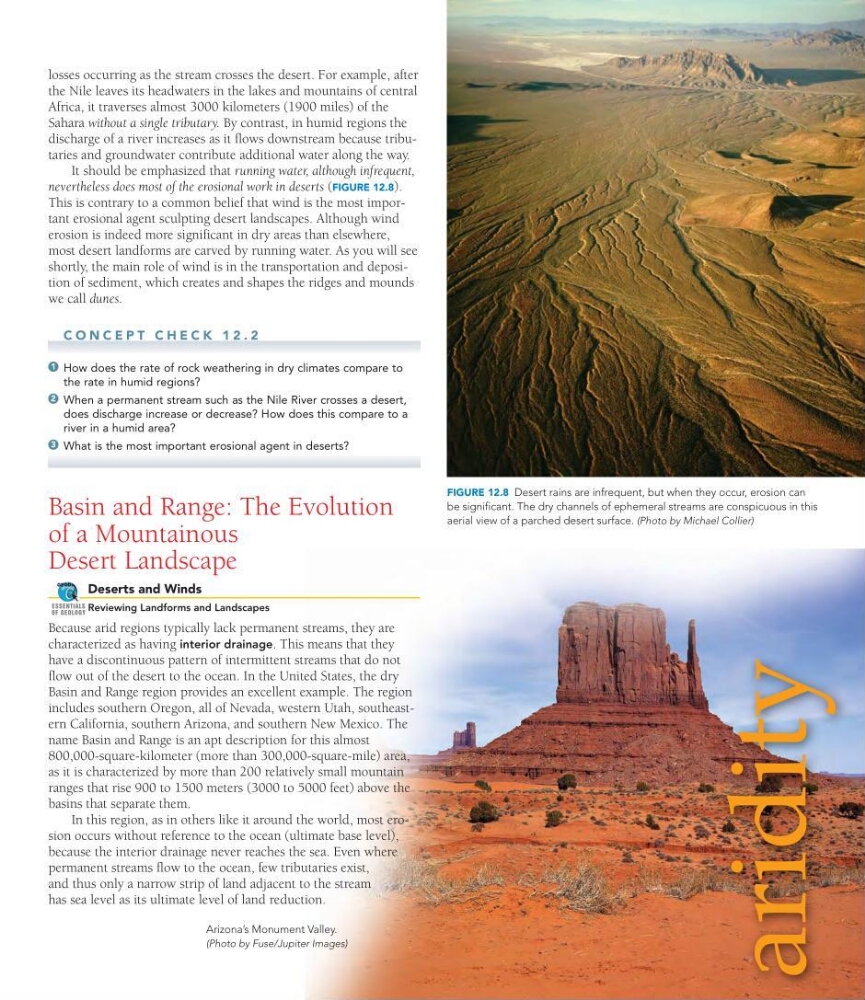
It should be emphasized that running water, although infrequent,
nevertheless does most of the erosional work in deserts (FIGURE 12.8).
This is contrary to a common belief that wind is the most important erosional agent sculpting desert landscapes. Although wind
erosion is indeed more significant in dry areas than elsewhere,
most desert landforms are carved by running water. As you will see
shortly, the main role of wind is in the transportation and deposition of sediment, which creates and shapes the ridges and mounds
we call dunes.
C O N C E P T C H E C K 1 2 . 2
How does the rate of rock weathering in dry climates compare to
the rate in humid regions?
When a permanent stream such as the Nile River crosses a desert,
does discharge increase or decrease? How does this compare to a
river in a humid area?
What is the most important erosional agent in deserts?
Basin and Range: The Evolution
of a Mountainous
Desert Landscape
Deserts and Winds
Reviewing Landforms and Landscapes
Because arid regions typically lack permanent streams, they are
characterized as having interior drainage. This means that they
have a discontinuous pattern of intermittent streams that do not
flow out of the desert to the ocean. In the United States, the dry
Basin and Range region provides an excellent example. The region
includes southern Oregon, all of Nevada, western Utah, southeastern California, southern Arizona, and southern New Mexico. The
name Basin and Range is an apt description for this almost
800,000-square-kilometer (more than 300,000-square-mile) area,
as it is characterized by more than 200 relatively small mountain
ranges that rise 900 to 1500 meters (3000 to 5000 feet) above the
basins that separate them.
In this region, as in others like it around the world, most erosion occurs without reference to the ocean (ultimate base level),
because the interior drainage never reaches the sea. Even where
permanent streams flow to the ocean, few tributaries exist,
and thus only a narrow strip of land adjacent to the stream
has sea level as its ultimate level of land reduction.
GEODe
ESSENTIALS
OF GEOLOGY
3
2
1
FIGURE 12.8 Desert rains are infrequent, but when they occur, erosion can
be significant. The dry channels of ephemeral streams are conspicuous in this
aerial view of a parched desert surface. (Photo by Michael Collier)
Arizona’s Monument Valley.
(Photo by Fuse/Jupiter Images)
losses occurring as the stream crosses the desert. For example, after
the Nile leaves its headwaters in the lakes and mountains of central
Africa, it traverses almost 3000 kilometers (1900 miles) of the
Sahara without a single tributary. By contrast, in humid regions the
discharge of a river increases as it flows downstream because tributaries and groundwater contribute additional water along the way.
It should be emphasized that running water, although infrequent,
nevertheless does most of the erosional work in deserts (FIGURE 12.8).
This is contrary to a common belief that wind is the most important erosional agent sculpting desert landscapes. Although wind
erosion is indeed more significant in dry areas than elsewhere,
most desert landforms are carved by running water. As you will see
shortly, the main role of wind is in the transportation and deposition of sediment, which creates and shapes the ridges and mounds
we call dunes.
C O N C E P T C H E C K 1 2 . 2
How does the rate of rock weathering in dry climates compare to
the rate in humid regions?
When a permanent stream such as the Nile River crosses a desert,
does discharge increase or decrease? How does this compare to a
river in a humid area?
What is the most important erosional agent in deserts?
Basin and Range: The Evolution
of a Mountainous
Desert Landscape
Deserts and Winds
Reviewing Landforms and Landscapes
Because arid regions typically lack permanent streams, they are
characterized as having interior drainage. This means that they
have a discontinuous pattern of intermittent streams that do not
flow out of the desert to the ocean. In the United States, the dry
Basin and Range region provides an excellent example. The region
includes southern Oregon, all of Nevada, western Utah, southeastern California, southern Arizona, and southern New Mexico. The
name Basin and Range is an apt description for this almost
800,000-square-kilometer (more than 300,000-square-mile) area,
as it is characterized by more than 200 relatively small mountain
ranges that rise 900 to 1500 meters (3000 to 5000 feet) above the
basins that separate them.
In this region, as in others like it around the world, most erosion occurs without reference to the ocean (ultimate base level),
because the interior drainage never reaches the sea. Even where
permanent streams flow to the ocean, few tributaries exist,
and thus only a narrow strip of land adjacent to the stream
has sea level as its ultimate level of land reduction.
GEODe
ESSENTIALS
OF GEOLOGY
3
2
1
FIGURE 12.8 Desert rains are infrequent, but when they occur, erosion can
be significant. The dry channels of ephemeral streams are conspicuous in this
aerial view of a parched desert surface. (Photo by Michael Collier)
Arizona’s Monument Valley.
(Photo by Fuse/Jupiter Images)