

CHAPTER 11 Glaciers and Glaciation
280
Glacial Lake Agassiz
Remnant lakes
Manitoba
Ontario
Saskatchewan
Minnesota
North Dakota
Wisconsin
Lac La Ronge
Cedar
Lake
Lake
Winnipeg
Lake
Winnipegosis
Lake
Manitoba
Lake of
the Woods
Red
Lakes
La ke Su pe rio r
Hudson Bay
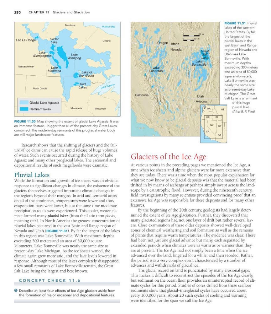
FIGURE 11.30 Map showing the extent of glacial Lake Agassiz. It was
an immense feature—bigger than all of the present-day Great Lakes
combined. The modern-day remnants of this proglacial water body
are still major landscape features.
Oregon Idaho
Nevada
Lake
Lahontan
Lake
Bonneville
California
Utah
Arizona
WA
OR
MT
ID
NV
CA
UT
AZ
Great
Salt
Lake
0
120 mi
0
120 km
FIGURE 11.31 Pluvial
lakes of the western
United States. By far
the largest of the
pluvial lakes in the
vast Basin and Range
region of Nevada and
Utah was Lake
Bonneville. With
maximum depths
exceeding 300 meters
and an area of 50,000
square kilometers,
Lake Bonneville was
nearly the same size
as present-day Lake
Michigan. The Great
Salt Lake is a remnant
of this huge
pluvial lake.
(After R. F. Flint)
Research shows that the shifting of glaciers and the failure of ice dams can cause the rapid release of huge volumes
of water. Such events occurred during the history of Lake
Agassiz and many other proglacial lakes. The erosional and
depositional results of such megafloods were dramatic.
Pluvial Lakes
While the formation and growth of ice sheets was an obvious
response to significant changes in climate, the existence of the
glaciers themselves triggered important climatic changes in
the regions beyond their margins. In arid and semiarid areas
on all of the continents, temperatures were lower and thus
evaporation rates were lower, but at the same time moderate
precipitation totals were experienced. This cooler, wetter climate formed many pluvial lakes (from the Latin term pluvis,
meaning rain). In North America the greatest concentration of
pluvial lakes occurred in the vast Basin and Range region of
Nevada and Utah (FIGURE 11.31). By far the largest of the lakes
in this region was Lake Bonneville. With maximum depths
exceeding 300 meters and an area of 50,000 square
kilometers, Lake Bonneville was nearly the same size as
present-day Lake Michigan. As the ice sheets waned, the
climate again grew more arid, and the lake levels lowered in
response. Although most of the lakes completely disappeared,
a few small remnants of Lake Bonneville remain, the Great
Salt Lake being the largest and best known.
C O N C E P T C H E C K 1 1 . 6
Describe at least four effects of Ice Age glaciers aside from
the formation of major erosional and depositional features.
1
Glaciers of the Ice Age
At various points in the preceding pages we mentioned the Ice Age, a
time when ice sheets and alpine glaciers were far more extensive than
they are today. There was a time when the most popular explanation for
what we now know to be glacial deposits was that the material had been
drifted in by means of icebergs or perhaps simply swept across the landscape by a catastrophic flood. However, during the nineteenth century,
field investigations by many scientists provided convincing proof that an
extensive Ice Age was responsible for these deposits and for many other
features.
By the beginning of the 20th century, geologists had largely determined the extent of Ice Age glaciation. Further, they discovered that
many glaciated regions had not one layer of drift but rather several layers. Close examination of these older deposits showed well-developed
zones of chemical weathering and soil formation as well as the remains
of plants that require warm temperatures. The evidence was clear: There
had been not just one glacial advance but many, each separated by
extended periods when climates were as warm as or warmer than they
are at present. The Ice Age had not simply been a time when the ice
advanced over the land, lingered for a while, and then receded. Rather,
the period was a very complex event characterized by a number of
advances and withdrawals of glacial ice.
The glacial record on land is punctuated by many erosional gaps.
This makes it difficult to reconstruct the episodes of the Ice Age clearly,
but sediment on the ocean floor provides an uninterrupted record of climate cycles for this period. Studies of cores drilled from these seafloor
sediments show that glacial–interglacial cycles have occurred about
every 100,000 years. About 20 such cycles of cooling and warming
were identified for the span we call the Ice Age.
280
Glacial Lake Agassiz
Remnant lakes
Manitoba
Ontario
Saskatchewan
Minnesota
North Dakota
Wisconsin
Lac La Ronge
Cedar
Lake
Lake
Winnipeg
Lake
Winnipegosis
Lake
Manitoba
Lake of
the Woods
Red
Lakes
La ke Su pe rio r
Hudson Bay
FIGURE 11.30 Map showing the extent of glacial Lake Agassiz. It was
an immense feature—bigger than all of the present-day Great Lakes
combined. The modern-day remnants of this proglacial water body
are still major landscape features.
Oregon Idaho
Nevada
Lake
Lahontan
Lake
Bonneville
California
Utah
Arizona
WA
OR
MT
ID
NV
CA
UT
AZ
Great
Salt
Lake
0
120 mi
0
120 km
FIGURE 11.31 Pluvial
lakes of the western
United States. By far
the largest of the
pluvial lakes in the
vast Basin and Range
region of Nevada and
Utah was Lake
Bonneville. With
maximum depths
exceeding 300 meters
and an area of 50,000
square kilometers,
Lake Bonneville was
nearly the same size
as present-day Lake
Michigan. The Great
Salt Lake is a remnant
of this huge
pluvial lake.
(After R. F. Flint)
Research shows that the shifting of glaciers and the failure of ice dams can cause the rapid release of huge volumes
of water. Such events occurred during the history of Lake
Agassiz and many other proglacial lakes. The erosional and
depositional results of such megafloods were dramatic.
Pluvial Lakes
While the formation and growth of ice sheets was an obvious
response to significant changes in climate, the existence of the
glaciers themselves triggered important climatic changes in
the regions beyond their margins. In arid and semiarid areas
on all of the continents, temperatures were lower and thus
evaporation rates were lower, but at the same time moderate
precipitation totals were experienced. This cooler, wetter climate formed many pluvial lakes (from the Latin term pluvis,
meaning rain). In North America the greatest concentration of
pluvial lakes occurred in the vast Basin and Range region of
Nevada and Utah (FIGURE 11.31). By far the largest of the lakes
in this region was Lake Bonneville. With maximum depths
exceeding 300 meters and an area of 50,000 square
kilometers, Lake Bonneville was nearly the same size as
present-day Lake Michigan. As the ice sheets waned, the
climate again grew more arid, and the lake levels lowered in
response. Although most of the lakes completely disappeared,
a few small remnants of Lake Bonneville remain, the Great
Salt Lake being the largest and best known.
C O N C E P T C H E C K 1 1 . 6
Describe at least four effects of Ice Age glaciers aside from
the formation of major erosional and depositional features.
1
Glaciers of the Ice Age
At various points in the preceding pages we mentioned the Ice Age, a
time when ice sheets and alpine glaciers were far more extensive than
they are today. There was a time when the most popular explanation for
what we now know to be glacial deposits was that the material had been
drifted in by means of icebergs or perhaps simply swept across the landscape by a catastrophic flood. However, during the nineteenth century,
field investigations by many scientists provided convincing proof that an
extensive Ice Age was responsible for these deposits and for many other
features.
By the beginning of the 20th century, geologists had largely determined the extent of Ice Age glaciation. Further, they discovered that
many glaciated regions had not one layer of drift but rather several layers. Close examination of these older deposits showed well-developed
zones of chemical weathering and soil formation as well as the remains
of plants that require warm temperatures. The evidence was clear: There
had been not just one glacial advance but many, each separated by
extended periods when climates were as warm as or warmer than they
are at present. The Ice Age had not simply been a time when the ice
advanced over the land, lingered for a while, and then receded. Rather,
the period was a very complex event characterized by a number of
advances and withdrawals of glacial ice.
The glacial record on land is punctuated by many erosional gaps.
This makes it difficult to reconstruct the episodes of the Ice Age clearly,
but sediment on the ocean floor provides an uninterrupted record of climate cycles for this period. Studies of cores drilled from these seafloor
sediments show that glacial–interglacial cycles have occurred about
every 100,000 years. About 20 such cycles of cooling and warming
were identified for the span we call the Ice Age.