

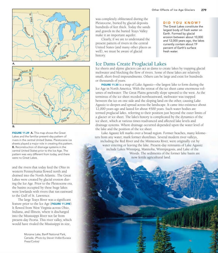
FIGURE 11.29 A. This map shows the Great
Lakes and the familiar present-day pattern of
rivers in the central United States. Pleistocene ice
sheets played a major role in creating this pattern.
B. Reconstruction of drainage systems in the
central United States prior to the Ice Age. The
pattern was very different from today, and there
were no Great Lakes.
279
Other Effects of Ice Age Glaciers
was completely obliterated during the
Pleistocene, buried by glacial deposits
hundreds of feet thick. Today the sands
and gravels in the buried Teays Valley
make it an important aquifer.
Clearly, if we are to understand the
present pattern of rivers in the central
United States (and many other places as
well), we must be aware of glacial
history.
Ice Dams Create Proglacial Lakes
Ice sheets and alpine glaciers can act as dams to create lakes by trapping glacial
meltwater and blocking the flow of rivers. Some of these lakes are relatively
small, short-lived impoundments. Others can be large and exist for hundreds
or thousands of years.
FIGURE 11.30 is a map of Lake Agassiz—the largest lake to form during the
Ice Age in North America. With the retreat of the ice sheet came enormous volumes of meltwater. The Great Plains generally slope upward to the west. As the
terminus of the ice sheet receded northeastward, meltwater was trapped
between the ice on one side and the sloping land on the other, causing Lake
Agassiz to deepen and spread across the landscape. It came into existence about
12,000 years ago and lasted for about 4500 years. Such water bodies are
termed proglacial lakes, referring to their position just beyond the outer limits of
a glacier or ice sheet. The lake’ s history is complicated by the dynamics of the
ice sheet, which at various times readvanced and affected lake levels and
drainage systems. Where drainage occurred depended upon the water level of
the lake and the position of the ice sheet.
Lake Agassiz left marks over a broad region. Former beaches, many kilometers from any water, mark former shorelines. Several modern river valleys,
including the Red River and the Minnesota River, were originally cut by
water entering or leaving the lake. Present-day remnants of Lake Agassiz
include Lakes Winnipeg, Manitoba, Winnipegosis, and Lake of the
Woods. The sediments of the former lake basin are
now fertile agricultural land.
O h io R
.
Illin o is
R .
M
is
s
o
u
r i R .
M
i s s is s ippi
R
.
O h io
R .
T e ay s R .
L o w e r M i s
s
o
u r i R .
M
is
s
is
s
i
p
p
i
R
.
Upp e
r Mis
s our i R .
Red
R.
A.
B.
R
ed
R.
Moraine Lake, Banff National Park,
Canada. (Photo by Steven Vidler/Eurasia
Press/Corbis)
and the rivers that today feed the Ohio in
western Pennsylvania flowed north and
drained into the North Atlantic. The Great
Lakes were created by glacial erosion during the Ice Age. Prior to the Pleistocene era,
the basins occupied by these huge lakes
were lowlands with rivers that ran eastward
to the Gulf of St. Lawrence.
The large Teays River was a significant
feature prior to the Ice Age (FIGURE 11.29B).
It flowed from West Virginia across Ohio,
Indiana, and Illinois, where it discharged
into the Mississippi River not far from
present-day Peoria. This river valley, which
would have rivaled the Mississippi in size,
D I D Y O U K N O W ?
The Great Lakes constitute the
largest body of fresh water on
Earth. Formed by glacial
erosion between about 10,000
and 12,000 years ago, the lakes
currently contain about 19
percent of Earth’s surface
fresh water.
Lakes and the familiar present-day pattern of
rivers in the central United States. Pleistocene ice
sheets played a major role in creating this pattern.
B. Reconstruction of drainage systems in the
central United States prior to the Ice Age. The
pattern was very different from today, and there
were no Great Lakes.
279
Other Effects of Ice Age Glaciers
was completely obliterated during the
Pleistocene, buried by glacial deposits
hundreds of feet thick. Today the sands
and gravels in the buried Teays Valley
make it an important aquifer.
Clearly, if we are to understand the
present pattern of rivers in the central
United States (and many other places as
well), we must be aware of glacial
history.
Ice Dams Create Proglacial Lakes
Ice sheets and alpine glaciers can act as dams to create lakes by trapping glacial
meltwater and blocking the flow of rivers. Some of these lakes are relatively
small, short-lived impoundments. Others can be large and exist for hundreds
or thousands of years.
FIGURE 11.30 is a map of Lake Agassiz—the largest lake to form during the
Ice Age in North America. With the retreat of the ice sheet came enormous volumes of meltwater. The Great Plains generally slope upward to the west. As the
terminus of the ice sheet receded northeastward, meltwater was trapped
between the ice on one side and the sloping land on the other, causing Lake
Agassiz to deepen and spread across the landscape. It came into existence about
12,000 years ago and lasted for about 4500 years. Such water bodies are
termed proglacial lakes, referring to their position just beyond the outer limits of
a glacier or ice sheet. The lake’ s history is complicated by the dynamics of the
ice sheet, which at various times readvanced and affected lake levels and
drainage systems. Where drainage occurred depended upon the water level of
the lake and the position of the ice sheet.
Lake Agassiz left marks over a broad region. Former beaches, many kilometers from any water, mark former shorelines. Several modern river valleys,
including the Red River and the Minnesota River, were originally cut by
water entering or leaving the lake. Present-day remnants of Lake Agassiz
include Lakes Winnipeg, Manitoba, Winnipegosis, and Lake of the
Woods. The sediments of the former lake basin are
now fertile agricultural land.
O h io R
.
Illin o is
R .
M
is
s
o
u
r i R .
M
i s s is s ippi
R
.
O h io
R .
T e ay s R .
L o w e r M i s
s
o
u r i R .
M
is
s
is
s
i
p
p
i
R
.
Upp e
r Mis
s our i R .
Red
R.
A.
B.
R
ed
R.
Moraine Lake, Banff National Park,
Canada. (Photo by Steven Vidler/Eurasia
Press/Corbis)
and the rivers that today feed the Ohio in
western Pennsylvania flowed north and
drained into the North Atlantic. The Great
Lakes were created by glacial erosion during the Ice Age. Prior to the Pleistocene era,
the basins occupied by these huge lakes
were lowlands with rivers that ran eastward
to the Gulf of St. Lawrence.
The large Teays River was a significant
feature prior to the Ice Age (FIGURE 11.29B).
It flowed from West Virginia across Ohio,
Indiana, and Illinois, where it discharged
into the Mississippi River not far from
present-day Peoria. This river valley, which
would have rivaled the Mississippi in size,
D I D Y O U K N O W ?
The Great Lakes constitute the
largest body of fresh water on
Earth. Formed by glacial
erosion between about 10,000
and 12,000 years ago, the lakes
currently contain about 19
percent of Earth’s surface
fresh water.