

CHAPTER 11 Glaciers and Glaciation
278
they are mined for sand and gravel, and for
this reason, eskers are disappearing in
some localities.
Kames are steep-sided hills that, like
eskers, are composed of sand and gravel
(Figure 11.27). Kames originate when
glacial meltwater washes sediment into
openings and depressions in the stagnant
wasting terminus of a glacier. When the ice
eventually melts away, the stratified drift is
left behind as mounds or hills.
C O N C E P T C H E C K 1 1 . 5
What is the difference between till and
stratified drift?
Distinguish between a terminal end
moraine and a recessional end moraine.
Describe the formation of a medial
moraine.
List four depositional features other than
moraines.
Other Effects
of Ice Age Glaciers
In addition to the massive erosional and
depositional work carried on by Ice-Age
glaciers, the ice sheets had other effects,
sometimes profound, on the landscape. For
example, as the ice advanced and retreated,
animals and plants were forced to migrate.
This led to stresses that some organisms
could not tolerate. Hence, a number of
plants and animals became extinct. Other
effects of Ice Age glaciers that are described
in this section involve adjustments in
Earth’ s crust due to the addition and
removal of ice and sea-level changes associated with the formation and melting of ice
sheets. The advance and retreat of ice
sheets also led to significant changes in the
routes taken by rivers. In some regions, glaciers acted as dams that created large lakes.
When these ice dams failed, the effects on
the landscape were profound. In areas that
today are deserts, lakes of another type,
called pluvial lakes, formed.
Crustal Subsidence
and Rebound
In areas that were centers of ice accumulation, such as Scandinavia and the Canadian
4
3
2
1
Shield, the land has been
slowly rising over the past
several thousand years.
Uplifting of almost 300
meters (1000 feet) has
occurred in the Hudson
Bay region. This, too, is the
result of the continental ice
sheets, but how can glacial
ice cause such vertical
crustal movement? We now
understand that the land is
rising because the added
weight of the 3-kilometer-thick (2-mile-thick) mass of ice caused downwarping of Earth’ s
crust. Following the removal of this immense load, the crust has been adjusting by gradually rebounding upward ever since.*
Sea-Level Changes
One of the more interesting and perhaps dramatic effects of the Ice Age was the fall and rise
of sea level that accompanied the advance and retreat of the glaciers. Today if all of Earth’ s
glaciers melted, sea level would rise approximately 70 meters (230 feet) worldwide.
Although the total volume of glacial ice today is great, exceeding 25 million cubic kilometers, during the Ice Age the volume of glacial ice amounted to about 70 million cubic
kilometers (45 million cubic kilometers more than at present). Because we know that the
snow from which glaciers are made ultimately comes from the evaporation of ocean water,
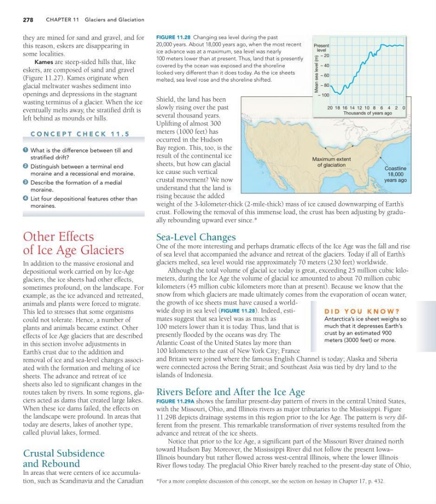
the growth of ice sheets must have caused a worldwide drop in sea level (FIGURE 11.28). Indeed, estimates suggest that sea level was as much as
100 meters lower than it is today. Thus, land that is
presently flooded by the oceans was dry. The
Atlantic Coast of the United States lay more than
100 kilometers to the east of New York City; France
and Britain were joined where the famous English Channel is today; Alaska and Siberia
were connected across the Bering Strait; and Southeast Asia was tied by dry land to the
islands of Indonesia.
Rivers Before and After the Ice Age
FIGURE 11.29A shows the familiar present-day pattern of rivers in the central United States,
with the Missouri, Ohio, and Illinois rivers as major tributaries to the Mississippi. Figure
11.29B depicts drainage systems in this region prior to the Ice Age. The pattern is very different from the present. This remarkable transformation of river systems resulted from the
advance and retreat of the ice sheets.
Notice that prior to the Ice Age, a significant part of the Missouri River drained north
toward Hudson Bay. Moreover, the Mississippi River did not follow the present Iowa–
Illinois boundary but rather flowed across west-central Illinois, where the lower Illinois
River flows today. The preglacial Ohio River barely reached to the present-day state of Ohio,
*For a more complete discussion of this concept, see the section on Isostasy in Chapter 17, p. 432.
D I D Y O U K N O W ?
Antarctica’s ice sheet weighs so
much that it depresses Earth’s
crust by an estimated 900
meters (3000 feet) or more.
Coastline
18,000
years ago
Maximum extent
of glaciation
Mean sea level (m)
Present
level
– 20
– 40
– 60
– 80
– 100
20 18 16 14 12 10 8 6 4 2 0
Thousands of years ago
FIGURE 11.28 Changing sea level during the past
20,000 years. About 18,000 years ago, when the most recent
ice advance was at a maximum, sea level was nearly
100 meters lower than at present. Thus, land that is presently
covered by the ocean was exposed and the shoreline
looked very different than it does today. As the ice sheets
melted, sea level rose and the shoreline shifted.
278
they are mined for sand and gravel, and for
this reason, eskers are disappearing in
some localities.
Kames are steep-sided hills that, like
eskers, are composed of sand and gravel
(Figure 11.27). Kames originate when
glacial meltwater washes sediment into
openings and depressions in the stagnant
wasting terminus of a glacier. When the ice
eventually melts away, the stratified drift is
left behind as mounds or hills.
C O N C E P T C H E C K 1 1 . 5
What is the difference between till and
stratified drift?
Distinguish between a terminal end
moraine and a recessional end moraine.
Describe the formation of a medial
moraine.
List four depositional features other than
moraines.
Other Effects
of Ice Age Glaciers
In addition to the massive erosional and
depositional work carried on by Ice-Age
glaciers, the ice sheets had other effects,
sometimes profound, on the landscape. For
example, as the ice advanced and retreated,
animals and plants were forced to migrate.
This led to stresses that some organisms
could not tolerate. Hence, a number of
plants and animals became extinct. Other
effects of Ice Age glaciers that are described
in this section involve adjustments in
Earth’ s crust due to the addition and
removal of ice and sea-level changes associated with the formation and melting of ice
sheets. The advance and retreat of ice
sheets also led to significant changes in the
routes taken by rivers. In some regions, glaciers acted as dams that created large lakes.
When these ice dams failed, the effects on
the landscape were profound. In areas that
today are deserts, lakes of another type,
called pluvial lakes, formed.
Crustal Subsidence
and Rebound
In areas that were centers of ice accumulation, such as Scandinavia and the Canadian
4
3
2
1
Shield, the land has been
slowly rising over the past
several thousand years.
Uplifting of almost 300
meters (1000 feet) has
occurred in the Hudson
Bay region. This, too, is the
result of the continental ice
sheets, but how can glacial
ice cause such vertical
crustal movement? We now
understand that the land is
rising because the added
weight of the 3-kilometer-thick (2-mile-thick) mass of ice caused downwarping of Earth’ s
crust. Following the removal of this immense load, the crust has been adjusting by gradually rebounding upward ever since.*
Sea-Level Changes
One of the more interesting and perhaps dramatic effects of the Ice Age was the fall and rise
of sea level that accompanied the advance and retreat of the glaciers. Today if all of Earth’ s
glaciers melted, sea level would rise approximately 70 meters (230 feet) worldwide.
Although the total volume of glacial ice today is great, exceeding 25 million cubic kilometers, during the Ice Age the volume of glacial ice amounted to about 70 million cubic
kilometers (45 million cubic kilometers more than at present). Because we know that the
snow from which glaciers are made ultimately comes from the evaporation of ocean water,
the growth of ice sheets must have caused a worldwide drop in sea level (FIGURE 11.28). Indeed, estimates suggest that sea level was as much as
100 meters lower than it is today. Thus, land that is
presently flooded by the oceans was dry. The
Atlantic Coast of the United States lay more than
100 kilometers to the east of New York City; France
and Britain were joined where the famous English Channel is today; Alaska and Siberia
were connected across the Bering Strait; and Southeast Asia was tied by dry land to the
islands of Indonesia.
Rivers Before and After the Ice Age
FIGURE 11.29A shows the familiar present-day pattern of rivers in the central United States,
with the Missouri, Ohio, and Illinois rivers as major tributaries to the Mississippi. Figure
11.29B depicts drainage systems in this region prior to the Ice Age. The pattern is very different from the present. This remarkable transformation of river systems resulted from the
advance and retreat of the ice sheets.
Notice that prior to the Ice Age, a significant part of the Missouri River drained north
toward Hudson Bay. Moreover, the Mississippi River did not follow the present Iowa–
Illinois boundary but rather flowed across west-central Illinois, where the lower Illinois
River flows today. The preglacial Ohio River barely reached to the present-day state of Ohio,
*For a more complete discussion of this concept, see the section on Isostasy in Chapter 17, p. 432.
D I D Y O U K N O W ?
Antarctica’s ice sheet weighs so
much that it depresses Earth’s
crust by an estimated 900
meters (3000 feet) or more.
Coastline
18,000
years ago
Maximum extent
of glaciation
Mean sea level (m)
Present
level
– 20
– 40
– 60
– 80
– 100
20 18 16 14 12 10 8 6 4 2 0
Thousands of years ago
FIGURE 11.28 Changing sea level during the past
20,000 years. About 18,000 years ago, when the most recent
ice advance was at a maximum, sea level was nearly
100 meters lower than at present. Thus, land that is presently
covered by the ocean was exposed and the shoreline
looked very different than it does today. As the ice sheets
melted, sea level rose and the shoreline shifted.