

valleys. Prior to glaciation, mountain valleys are
characteristically narrow and V-shaped because
streams are well above base level and are therefore
downcutting. However, during glaciation these narrow valleys undergo a transformation as the glacier
widens and deepens them, creating a U-shaped
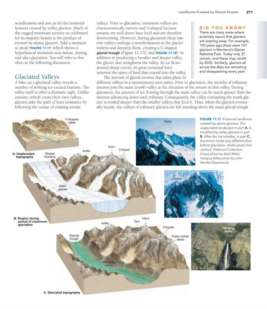
glacial trough (Figure 11.17C and FIGURE 11.18). In
addition to producing a broader and deeper valley,
the glacier also straightens the valley. As ice flows
around sharp curves, its great erosional force
removes the spurs of land that extend into the valley.
The amount of glacial erosion that takes place in
different valleys in a mountainous area varies. Prior to glaciation, the mouths of tributary
streams join the main (trunk) valley at the elevation of the stream in that valley. During
glaciation, the amount of ice flowing through the main valley can be much greater than the
amount advancing down each tributary. Consequently, the valley containing the trunk glacier is eroded deeper than the smaller valleys that feed it. Thus, when the glaciers eventually recede, the valleys of tributary glaciers are left standing above the main glacial trough
271
Landforms Created by Glacial Erosion
wonderment and awe as do the erosional
features created by valley glaciers. Much of
the rugged mountain scenery so celebrated
for its majestic beauty is the product of
erosion by alpine glaciers. Take a moment
to study FIGURE 11.17, which shows a
hypothetical mountain area before, during,
and after glaciation. You will refer to this
often in the following discussion.
Glaciated Valleys
A hike up a glaciated valley reveals a
number of striking ice-created features. The
valley itself is often a dramatic sight. Unlike
streams, which create their own valleys,
glaciers take the path of least resistance by
following the course of existing stream
D I D Y O U K N O W ?
There are many areas where
scientists report that glaciers
are wasting away. For example,
150 years ago there were 147
glaciers in Montana’s Glacier
National Park. Today only 37
remain, and these may vanish
by 2030. Similarly, glaciers all
across the Alps are retreating
and disappearing every year.
Hanging
valley
A. Unglaciated
topography
V-shaped
valley
Region during
period of maximum
glaciation
B.
Arête
Horn
Cirques
Medial
moraine
Main
glacier
C. Glaciated topography
Hanging
valley
Arête
Horn
Tarn
Pater noster
lakes
Cirques
Glacial
trough
Cirque
Arête
FIGURE 11.17 Erosional landforms
created by alpine glaciers. The
unglaciated landscape in part A. is
modified by valley glaciers in part
B. After the ice recedes, in part C.,
the terrain looks very different than
before glaciation. (Arête photo from
James E. Patterson Collection;
Cirque photo by Marli Miller,
Hanging Valley photo by John
Warden/Superstock)
characteristically narrow and V-shaped because
streams are well above base level and are therefore
downcutting. However, during glaciation these narrow valleys undergo a transformation as the glacier
widens and deepens them, creating a U-shaped
glacial trough (Figure 11.17C and FIGURE 11.18). In
addition to producing a broader and deeper valley,
the glacier also straightens the valley. As ice flows
around sharp curves, its great erosional force
removes the spurs of land that extend into the valley.
The amount of glacial erosion that takes place in
different valleys in a mountainous area varies. Prior to glaciation, the mouths of tributary
streams join the main (trunk) valley at the elevation of the stream in that valley. During
glaciation, the amount of ice flowing through the main valley can be much greater than the
amount advancing down each tributary. Consequently, the valley containing the trunk glacier is eroded deeper than the smaller valleys that feed it. Thus, when the glaciers eventually recede, the valleys of tributary glaciers are left standing above the main glacial trough
271
Landforms Created by Glacial Erosion
wonderment and awe as do the erosional
features created by valley glaciers. Much of
the rugged mountain scenery so celebrated
for its majestic beauty is the product of
erosion by alpine glaciers. Take a moment
to study FIGURE 11.17, which shows a
hypothetical mountain area before, during,
and after glaciation. You will refer to this
often in the following discussion.
Glaciated Valleys
A hike up a glaciated valley reveals a
number of striking ice-created features. The
valley itself is often a dramatic sight. Unlike
streams, which create their own valleys,
glaciers take the path of least resistance by
following the course of existing stream
D I D Y O U K N O W ?
There are many areas where
scientists report that glaciers
are wasting away. For example,
150 years ago there were 147
glaciers in Montana’s Glacier
National Park. Today only 37
remain, and these may vanish
by 2030. Similarly, glaciers all
across the Alps are retreating
and disappearing every year.
Hanging
valley
A. Unglaciated
topography
V-shaped
valley
Region during
period of maximum
glaciation
B.
Arête
Horn
Cirques
Medial
moraine
Main
glacier
C. Glaciated topography
Hanging
valley
Arête
Horn
Tarn
Pater noster
lakes
Cirques
Glacial
trough
Cirque
Arête
FIGURE 11.17 Erosional landforms
created by alpine glaciers. The
unglaciated landscape in part A. is
modified by valley glaciers in part
B. After the ice recedes, in part C.,
the terrain looks very different than
before glaciation. (Arête photo from
James E. Patterson Collection;
Cirque photo by Marli Miller,
Hanging Valley photo by John
Warden/Superstock)