

247
Wells
Darcy also discovered that the flow
velocity varied with the permeability of the
sediment—groundwater flows more rapidly
through sediments having greater permeability than through materials having lower
permeability. This factor is known as
hydraulic conductivity and is a coefficient
that takes into account the permeability of
the aquifer and the viscosity of the fluid.
To determine discharge (Q)—that is,
the actual volume of water that flows
through an aquifer in a specified time—the
following equation is used:
where
is the hydraulic gradient, K
is the coefficient that represents hydraulic
conductivity, and A is the cross-sectional
area of the aquifer. This expression has
come to be called Darcy’s law.
C O N C E P T C H E C K 1 0 . 5
Distinguish between porosity and
permeability.
What is the difference between an aquifer
and an aquitard?
What factors cause water to follow the
paths shown in Figure 10.8?
Relate groundwater movement to hydraulic
gradient and hydraulic conductivity.
Springs
Groundwater
Springs and Wells
Springs have aroused the curiosity and
wonder of people for thousands of years.
The fact that springs were, and to some
people still are, rather mysterious phenomena is not difficult to understand, for here
is water flowing freely from the ground in
all kinds of weather in seemingly inexhaustible supply but with no obvious
source.
Not until the middle of the 1600s did
the French physicist Pierre Perrault invalidate the age-old assumption that precipitation could not adequately account for the
amount of water emanating from springs
and flowing in rivers. Over several years
GEODe
ESSENTIALS
OF GEOLOGY
4
3
2
1
h 1 - h 2
d
Q =
K A(h 1 - h 2 )
d
Perrault computed the quantity
of water that fell on France’ s
Seine River basin. He then
calculated the mean annual
runoff by measuring the
river’ s discharge. After
allowing for the loss of
water by evaporation, he
showed that there was sufficient water remaining to feed
the springs. Thanks to Perrault’ s pioneering efforts and
the measurements by many afterward, we now know that the
source of springs is water from the
zone of saturation and that the ultimate
source of this water is precipitation.
Whenever the water table intersects
Earth’ s surface, a natural outflow of
groundwater results, which we call a
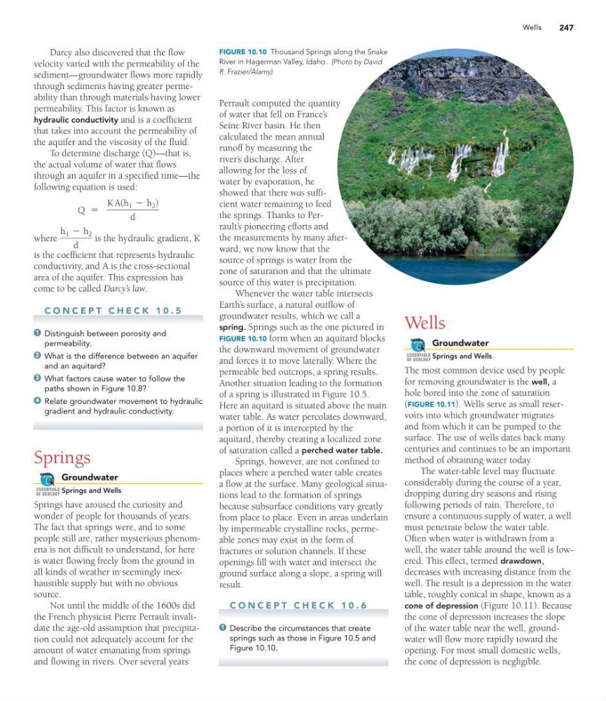
spring. Springs such as the one pictured in
FIGURE 10.10 form when an aquitard blocks
the downward movement of groundwater
and forces it to move laterally. Where the
permeable bed outcrops, a spring results.
Another situation leading to the formation
of a spring is illustrated in Figure 10.5.
Here an aquitard is situated above the main
water table. As water percolates downward,
a portion of it is intercepted by the
aquitard, thereby creating a localized zone
of saturation called a perched water table.
Springs, however, are not confined to
places where a perched water table creates
a flow at the surface. Many geological situations lead to the formation of springs
because subsurface conditions vary greatly
from place to place. Even in areas underlain
by impermeable crystalline rocks, permeable zones may exist in the form of
fractures or solution channels. If these
openings fill with water and intersect the
ground surface along a slope, a spring will
result.
C O N C E P T C H E C K 1 0 . 6
Describe the circumstances that create
springs such as those in Figure 10.5 and
Figure 10.10.
1
Wells
Groundwater
Springs and Wells
The most common device used by people
for removing groundwater is the well, a
hole bored into the zone of saturation
(FIGURE 10.11). Wells serve as small reservoirs into which groundwater migrates
and from which it can be pumped to the
surface. The use of wells dates back many
centuries and continues to be an important
method of obtaining water today.
The water-table level may fluctuate
considerably during the course of a year,
dropping during dry seasons and rising
following periods of rain. Therefore, to
ensure a continuous supply of water, a well
must penetrate below the water table.
Often when water is withdrawn from a
well, the water table around the well is lowered. This effect, termed drawdown,
decreases with increasing distance from the
well. The result is a depression in the water
table, roughly conical in shape, known as a
cone of depression (Figure 10.11). Because
the cone of depression increases the slope
of the water table near the well, groundwater will flow more rapidly toward the
opening. For most small domestic wells,
the cone of depression is negligible.
GEODe
ESSENTIALS
OF GEOLOGY
FIGURE 10.10 Thousand Springs along the Snake
River in Hagerman Valley, Idaho. (Photo by David
R. Frazier/Alamy)
Wells
Darcy also discovered that the flow
velocity varied with the permeability of the
sediment—groundwater flows more rapidly
through sediments having greater permeability than through materials having lower
permeability. This factor is known as
hydraulic conductivity and is a coefficient
that takes into account the permeability of
the aquifer and the viscosity of the fluid.
To determine discharge (Q)—that is,
the actual volume of water that flows
through an aquifer in a specified time—the
following equation is used:
where
is the hydraulic gradient, K
is the coefficient that represents hydraulic
conductivity, and A is the cross-sectional
area of the aquifer. This expression has
come to be called Darcy’s law.
C O N C E P T C H E C K 1 0 . 5
Distinguish between porosity and
permeability.
What is the difference between an aquifer
and an aquitard?
What factors cause water to follow the
paths shown in Figure 10.8?
Relate groundwater movement to hydraulic
gradient and hydraulic conductivity.
Springs
Groundwater
Springs and Wells
Springs have aroused the curiosity and
wonder of people for thousands of years.
The fact that springs were, and to some
people still are, rather mysterious phenomena is not difficult to understand, for here
is water flowing freely from the ground in
all kinds of weather in seemingly inexhaustible supply but with no obvious
source.
Not until the middle of the 1600s did
the French physicist Pierre Perrault invalidate the age-old assumption that precipitation could not adequately account for the
amount of water emanating from springs
and flowing in rivers. Over several years
GEODe
ESSENTIALS
OF GEOLOGY
4
3
2
1
h 1 - h 2
d
Q =
K A(h 1 - h 2 )
d
Perrault computed the quantity
of water that fell on France’ s
Seine River basin. He then
calculated the mean annual
runoff by measuring the
river’ s discharge. After
allowing for the loss of
water by evaporation, he
showed that there was sufficient water remaining to feed
the springs. Thanks to Perrault’ s pioneering efforts and
the measurements by many afterward, we now know that the
source of springs is water from the
zone of saturation and that the ultimate
source of this water is precipitation.
Whenever the water table intersects
Earth’ s surface, a natural outflow of
groundwater results, which we call a
spring. Springs such as the one pictured in
FIGURE 10.10 form when an aquitard blocks
the downward movement of groundwater
and forces it to move laterally. Where the
permeable bed outcrops, a spring results.
Another situation leading to the formation
of a spring is illustrated in Figure 10.5.
Here an aquitard is situated above the main
water table. As water percolates downward,
a portion of it is intercepted by the
aquitard, thereby creating a localized zone
of saturation called a perched water table.
Springs, however, are not confined to
places where a perched water table creates
a flow at the surface. Many geological situations lead to the formation of springs
because subsurface conditions vary greatly
from place to place. Even in areas underlain
by impermeable crystalline rocks, permeable zones may exist in the form of
fractures or solution channels. If these
openings fill with water and intersect the
ground surface along a slope, a spring will
result.
C O N C E P T C H E C K 1 0 . 6
Describe the circumstances that create
springs such as those in Figure 10.5 and
Figure 10.10.
1
Wells
Groundwater
Springs and Wells
The most common device used by people
for removing groundwater is the well, a
hole bored into the zone of saturation
(FIGURE 10.11). Wells serve as small reservoirs into which groundwater migrates
and from which it can be pumped to the
surface. The use of wells dates back many
centuries and continues to be an important
method of obtaining water today.
The water-table level may fluctuate
considerably during the course of a year,
dropping during dry seasons and rising
following periods of rain. Therefore, to
ensure a continuous supply of water, a well
must penetrate below the water table.
Often when water is withdrawn from a
well, the water table around the well is lowered. This effect, termed drawdown,
decreases with increasing distance from the
well. The result is a depression in the water
table, roughly conical in shape, known as a
cone of depression (Figure 10.11). Because
the cone of depression increases the slope
of the water table near the well, groundwater will flow more rapidly toward the
opening. For most small domestic wells,
the cone of depression is negligible.
GEODe
ESSENTIALS
OF GEOLOGY
FIGURE 10.10 Thousand Springs along the Snake
River in Hagerman Valley, Idaho. (Photo by David
R. Frazier/Alamy)