

Water table
A. Gaining stream
B. Losing stream (connected)
C. Losing stream (disconnected)
Water table
Unsaturated
zone
Water table
Unsaturated
zone
important influence is the fact that groundwater moves very slowly and at varying
rates under different conditions. Because of
this, water tends to “pile up” beneath high
areas between stream valleys. If rainfall
were to cease completely, these water table
“hills” would slowly subside and gradually
approach the level of the valleys. However,
new supplies of rainwater are usually added
frequently enough to prevent this. Nevertheless, in times of extended drought, the
water table may drop enough to dry up
shallow wells. Other causes for the uneven
water table are variations in rainfall and
permeability from place to place.
Interaction between Groundwater
and Streams
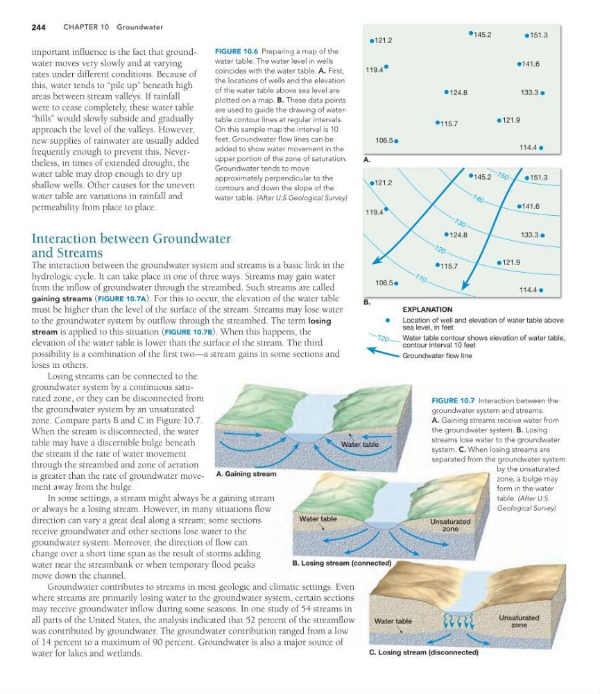
The interaction between the groundwater system and streams is a basic link in the
hydrologic cycle. It can take place in one of three ways. Streams may gain water
from the inflow of groundwater through the streambed. Such streams are called
gaining streams (FIGURE 10.7A). For this to occur, the elevation of the water table
must be higher than the level of the surface of the stream. Streams may lose water
to the groundwater system by outflow through the streambed. The term losing
stream is applied to this situation (FIGURE 10.7B). When this happens, the
elevation of the water table is lower than the surface of the stream. The third
possibility is a combination of the first two—a stream gains in some sections and
loses in others.
Losing streams can be connected to the
groundwater system by a continuous saturated zone, or they can be disconnected from
the groundwater system by an unsaturated
zone. Compare parts B and C in Figure 10.7.
When the stream is disconnected, the water
table may have a discernible bulge beneath
the stream if the rate of water movement
through the streambed and zone of aeration
is greater than the rate of groundwater movement away from the bulge.
In some settings, a stream might always be a gaining stream
or always be a losing stream. However, in many situations flow
direction can vary a great deal along a stream; some sections
receive groundwater and other sections lose water to the
groundwater system. Moreover, the direction of flow can
change over a short time span as the result of storms adding
water near the streambank or when temporary flood peaks
move down the channel.
Groundwater contributes to streams in most geologic and climatic settings. Even
where streams are primarily losing water to the groundwater system, certain sections
may receive groundwater inflow during some seasons. In one study of 54 streams in
all parts of the United States, the analysis indicated that 52 percent of the streamflow
was contributed by groundwater. The groundwater contribution ranged from a low
of 14 percent to a maximum of 90 percent. Groundwater is also a major source of
water for lakes and wetlands.
CHAPTER 10 Groundwater
244
EXPLANATION
Location of well and elevation of water table above
sea level, in feet
Water table contour shows elevation of water table,
contour interval 10 feet
Groundwater flow line
A.
B.
121.2
119.4
115.7
106.5
124.8
133.3
141.6
121.9
114.4
1 5 0
1 4 0
1 3 0
1 2 0
1 2 0
151.3
145.2
1 1 0
121.2
119.4
115.7
106.5
124.8
133.3
141.6
121.9
114.4
151.3
145.2
FIGURE 10.6 Preparing a map of the
water table. The water level in wells
coincides with the water table. A. First,
the locations of wells and the elevation
of the water table above sea level are
plotted on a map. B. These data points
are used to guide the drawing of watertable contour lines at regular intervals.
On this sample map the interval is 10
feet. Groundwater flow lines can be
added to show water movement in the
upper portion of the zone of saturation.
Groundwater tends to move
approximately perpendicular to the
contours and down the slope of the
water table. (After U.S Geological Survey)
FIGURE 10.7 Interaction between the
groundwater system and streams.
A. Gaining streams receive water from
the groundwater system. B. Losing
streams lose water to the groundwater
system. C. When losing streams are
separated from the groundwater system
by the unsaturated
zone, a bulge may
form in the water
table. (After U.S.
Geological Survey)
A. Gaining stream
B. Losing stream (connected)
C. Losing stream (disconnected)
Water table
Unsaturated
zone
Water table
Unsaturated
zone
important influence is the fact that groundwater moves very slowly and at varying
rates under different conditions. Because of
this, water tends to “pile up” beneath high
areas between stream valleys. If rainfall
were to cease completely, these water table
“hills” would slowly subside and gradually
approach the level of the valleys. However,
new supplies of rainwater are usually added
frequently enough to prevent this. Nevertheless, in times of extended drought, the
water table may drop enough to dry up
shallow wells. Other causes for the uneven
water table are variations in rainfall and
permeability from place to place.
Interaction between Groundwater
and Streams
The interaction between the groundwater system and streams is a basic link in the
hydrologic cycle. It can take place in one of three ways. Streams may gain water
from the inflow of groundwater through the streambed. Such streams are called
gaining streams (FIGURE 10.7A). For this to occur, the elevation of the water table
must be higher than the level of the surface of the stream. Streams may lose water
to the groundwater system by outflow through the streambed. The term losing
stream is applied to this situation (FIGURE 10.7B). When this happens, the
elevation of the water table is lower than the surface of the stream. The third
possibility is a combination of the first two—a stream gains in some sections and
loses in others.
Losing streams can be connected to the
groundwater system by a continuous saturated zone, or they can be disconnected from
the groundwater system by an unsaturated
zone. Compare parts B and C in Figure 10.7.
When the stream is disconnected, the water
table may have a discernible bulge beneath
the stream if the rate of water movement
through the streambed and zone of aeration
is greater than the rate of groundwater movement away from the bulge.
In some settings, a stream might always be a gaining stream
or always be a losing stream. However, in many situations flow
direction can vary a great deal along a stream; some sections
receive groundwater and other sections lose water to the
groundwater system. Moreover, the direction of flow can
change over a short time span as the result of storms adding
water near the streambank or when temporary flood peaks
move down the channel.
Groundwater contributes to streams in most geologic and climatic settings. Even
where streams are primarily losing water to the groundwater system, certain sections
may receive groundwater inflow during some seasons. In one study of 54 streams in
all parts of the United States, the analysis indicated that 52 percent of the streamflow
was contributed by groundwater. The groundwater contribution ranged from a low
of 14 percent to a maximum of 90 percent. Groundwater is also a major source of
water for lakes and wetlands.
CHAPTER 10 Groundwater
244
EXPLANATION
Location of well and elevation of water table above
sea level, in feet
Water table contour shows elevation of water table,
contour interval 10 feet
Groundwater flow line
A.
B.
121.2
119.4
115.7
106.5
124.8
133.3
141.6
121.9
114.4
1 5 0
1 4 0
1 3 0
1 2 0
1 2 0
151.3
145.2
1 1 0
121.2
119.4
115.7
106.5
124.8
133.3
141.6
121.9
114.4
151.3
145.2
FIGURE 10.6 Preparing a map of the
water table. The water level in wells
coincides with the water table. A. First,
the locations of wells and the elevation
of the water table above sea level are
plotted on a map. B. These data points
are used to guide the drawing of watertable contour lines at regular intervals.
On this sample map the interval is 10
feet. Groundwater flow lines can be
added to show water movement in the
upper portion of the zone of saturation.
Groundwater tends to move
approximately perpendicular to the
contours and down the slope of the
water table. (After U.S Geological Survey)
FIGURE 10.7 Interaction between the
groundwater system and streams.
A. Gaining streams receive water from
the groundwater system. B. Losing
streams lose water to the groundwater
system. C. When losing streams are
separated from the groundwater system
by the unsaturated
zone, a bulge may
form in the water
table. (After U.S.
Geological Survey)