

CHAPTER 9 Running Water
234
extensive 1997 flood along the Red River of
the North was preceded by an especially
snowy winter and an early spring blizzard.
Early April brought rapidly rising temperatures, melting the snow in a matter of
days, causing a record-breaking 500-year
flood. Roughly 4.5 million acres were
underwater, and the losses in the Grand
Forks, North Dakota, region exceeded
$3.5 billion.*
Regional floods can also be the result of
numerous heavy rain events. The extensive
and costly June 2008 floods in parts of the
Midwest were the result of record-breaking
rainfall on already waterlogged soils.
Indiana experienced its costliest weather
disaster in history, but Iowa suffered even
greater losses with 83 of its 99 counties
declared disaster areas. Nine of the state’ s
rivers were at or above previous record
flood levels and millions of acres of productive farmland were submerged. Thousands
of people were evacuated, mostly in Cedar
Rapids where more than 400 city blocks
were under water (see Figure 9.27).
FLASH FLOODS. Flash floods occur with
little warning and are potentially deadly
because they produce rapid rises in water
levels and can have devastating flow velocities. Rainfall intensity and duration, surface
conditions, and topography are among
the factors that influence flash flooding.
Mountainous areas are especially susceptible because steep slopes can funnel runoff
into narrow canyons with disastrous
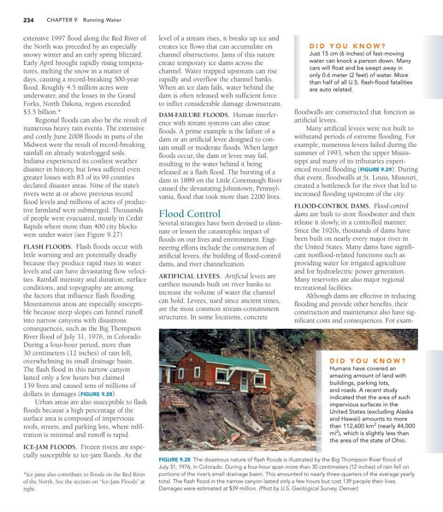
consequences, such as the Big Thompson
River flood of July 31, 1976, in Colorado.
During a four-hour period, more than
30 centimeters (12 inches) of rain fell,
overwhelming its small drainage basin.
The flash flood in this narrow canyon
lasted only a few hours but claimed
139 lives and caused tens of millions of
dollars in damages (FIGURE 9.28).
Urban areas are also susceptible to flash
floods because a high percentage of the
surface area is composed of impervious
roofs, streets, and parking lots, where infiltration is minimal and runoff is rapid.
ICE-JAM FLOODS. Frozen rivers are especially susceptible to ice-jam floods. As the
*Ice jams also contribute to floods on the Red River
of the North. See the section on “Ice-Jam Floods” at
right.
FIGURE 9.28 The disastrous nature of flash floods is illustrated by the Big Thompson River flood of
July 31, 1976, in Colorado. During a four-hour span more than 30 centimeters (12 inches) of rain fell on
portions of the river’s small drainage basin. This amounted to nearly three-quarters of the average yearly
total. The flash flood in the narrow canyon lasted only a few hours but cost 139 people their lives.
Damages were estimated at $39 million. (Phot by U.S. Geological Survey, Denver)
floodwalls are constructed that function as
artificial levees.
Many artificial levees were not built to
withstand periods of extreme flooding. For
example, numerous levees failed during the
summer of 1993, when the upper Mississippi and many of its tributaries experienced record flooding (FIGURE 9.29). During
that event, floodwalls at St. Louis, Missouri,
created a bottleneck for the river that led to
increased flooding upstream of the city.
FLOOD-CONTROL DAMS. Flood-control
dams are built to store floodwater and then
release it slowly, in a controlled manner.
Since the 1920s, thousands of dams have
been built on nearly every major river in
the United States. Many dams have significant nonflood-related functions such as
providing water for irrigated agriculture
and for hydroelectric power generation.
Many reservoirs are also major regional
recreational facilities.
Although dams are effective in reducing
flooding and provide other benefits, their
construction and maintenance also have significant costs and consequences. For examD I D Y O U K N O W ?
Just 15 cm (6 inches) of fast-moving
water can knock a person down. Many
cars will float and be swept away in
only 0.6 meter (2 feet) of water. More
than half of all U.S. flash-flood fatalities
are auto related.
D I D Y O U K N O W ?
Humans have covered an
amazing amount of land with
buildings, parking lots,
and roads. A recent study
indicated that the area of such
impervious surfaces in the
United States (excluding Alaska
and Hawaii) amounts to more
than 112,600 km
2 (nearly 44,000
mi
2
), which is slightly less than
the area of the state of Ohio.
level of a stream rises, it breaks up ice and
creates ice flows that can accumulate on
channel obstructions. Jams of this nature
create temporary ice dams across the
channel. Water trapped upstream can rise
rapidly and overflow the channel banks.
When an ice dam fails, water behind the
dam is often released with sufficient force
to inflict considerable damage downstream.
DAM-FAILURE FLOODS. Human interference with stream systems can also cause
floods. A prime example is the failure of a
dam or an artificial levee designed to contain small or moderate floods. When larger
floods occur, the dam or levee may fail,
resulting in the water behind it being
released as a flash flood. The bursting of a
dam in 1889 on the Little Conemaugh River
caused the devastating Johnstown, Pennsylvania, flood that took more than 2200 lives.
Flood Control
Several strategies have been devised to eliminate or lessen the catastrophic impact of
floods on our lives and environment. Engineering efforts include the construction of
artificial levees, the building of flood-control
dams, and river channelization.
ARTIFICIAL LEVEES. Artificial levees are
earthen mounds built on river banks to
increase the volume of water the channel
can hold. Levees, used since ancient times,
are the most common stream-containment
structures. In some locations, concrete
234
extensive 1997 flood along the Red River of
the North was preceded by an especially
snowy winter and an early spring blizzard.
Early April brought rapidly rising temperatures, melting the snow in a matter of
days, causing a record-breaking 500-year
flood. Roughly 4.5 million acres were
underwater, and the losses in the Grand
Forks, North Dakota, region exceeded
$3.5 billion.*
Regional floods can also be the result of
numerous heavy rain events. The extensive
and costly June 2008 floods in parts of the
Midwest were the result of record-breaking
rainfall on already waterlogged soils.
Indiana experienced its costliest weather
disaster in history, but Iowa suffered even
greater losses with 83 of its 99 counties
declared disaster areas. Nine of the state’ s
rivers were at or above previous record
flood levels and millions of acres of productive farmland were submerged. Thousands
of people were evacuated, mostly in Cedar
Rapids where more than 400 city blocks
were under water (see Figure 9.27).
FLASH FLOODS. Flash floods occur with
little warning and are potentially deadly
because they produce rapid rises in water
levels and can have devastating flow velocities. Rainfall intensity and duration, surface
conditions, and topography are among
the factors that influence flash flooding.
Mountainous areas are especially susceptible because steep slopes can funnel runoff
into narrow canyons with disastrous
consequences, such as the Big Thompson
River flood of July 31, 1976, in Colorado.
During a four-hour period, more than
30 centimeters (12 inches) of rain fell,
overwhelming its small drainage basin.
The flash flood in this narrow canyon
lasted only a few hours but claimed
139 lives and caused tens of millions of
dollars in damages (FIGURE 9.28).
Urban areas are also susceptible to flash
floods because a high percentage of the
surface area is composed of impervious
roofs, streets, and parking lots, where infiltration is minimal and runoff is rapid.
ICE-JAM FLOODS. Frozen rivers are especially susceptible to ice-jam floods. As the
*Ice jams also contribute to floods on the Red River
of the North. See the section on “Ice-Jam Floods” at
right.
FIGURE 9.28 The disastrous nature of flash floods is illustrated by the Big Thompson River flood of
July 31, 1976, in Colorado. During a four-hour span more than 30 centimeters (12 inches) of rain fell on
portions of the river’s small drainage basin. This amounted to nearly three-quarters of the average yearly
total. The flash flood in the narrow canyon lasted only a few hours but cost 139 people their lives.
Damages were estimated at $39 million. (Phot by U.S. Geological Survey, Denver)
floodwalls are constructed that function as
artificial levees.
Many artificial levees were not built to
withstand periods of extreme flooding. For
example, numerous levees failed during the
summer of 1993, when the upper Mississippi and many of its tributaries experienced record flooding (FIGURE 9.29). During
that event, floodwalls at St. Louis, Missouri,
created a bottleneck for the river that led to
increased flooding upstream of the city.
FLOOD-CONTROL DAMS. Flood-control
dams are built to store floodwater and then
release it slowly, in a controlled manner.
Since the 1920s, thousands of dams have
been built on nearly every major river in
the United States. Many dams have significant nonflood-related functions such as
providing water for irrigated agriculture
and for hydroelectric power generation.
Many reservoirs are also major regional
recreational facilities.
Although dams are effective in reducing
flooding and provide other benefits, their
construction and maintenance also have significant costs and consequences. For examD I D Y O U K N O W ?
Just 15 cm (6 inches) of fast-moving
water can knock a person down. Many
cars will float and be swept away in
only 0.6 meter (2 feet) of water. More
than half of all U.S. flash-flood fatalities
are auto related.
D I D Y O U K N O W ?
Humans have covered an
amazing amount of land with
buildings, parking lots,
and roads. A recent study
indicated that the area of such
impervious surfaces in the
United States (excluding Alaska
and Hawaii) amounts to more
than 112,600 km
2 (nearly 44,000
mi
2
), which is slightly less than
the area of the state of Ohio.
level of a stream rises, it breaks up ice and
creates ice flows that can accumulate on
channel obstructions. Jams of this nature
create temporary ice dams across the
channel. Water trapped upstream can rise
rapidly and overflow the channel banks.
When an ice dam fails, water behind the
dam is often released with sufficient force
to inflict considerable damage downstream.
DAM-FAILURE FLOODS. Human interference with stream systems can also cause
floods. A prime example is the failure of a
dam or an artificial levee designed to contain small or moderate floods. When larger
floods occur, the dam or levee may fail,
resulting in the water behind it being
released as a flash flood. The bursting of a
dam in 1889 on the Little Conemaugh River
caused the devastating Johnstown, Pennsylvania, flood that took more than 2200 lives.
Flood Control
Several strategies have been devised to eliminate or lessen the catastrophic impact of
floods on our lives and environment. Engineering efforts include the construction of
artificial levees, the building of flood-control
dams, and river channelization.
ARTIFICIAL LEVEES. Artificial levees are
earthen mounds built on river banks to
increase the volume of water the channel
can hold. Levees, used since ancient times,
are the most common stream-containment
structures. In some locations, concrete