

235
Chapter in Review
ple, reservoirs created by dams may cover valuable farmland, forests, historic
sites, and scenic valleys. Large dams can also cause significant damage to river
ecosystems that have developed over thousands of years.
Furthermore, building dams is not a permanent solution to flooding. Sedimentation behind a dam gradually diminishes the volume of its reservoir,
reducing the long-term effectiveness of this flood-control measure.
CHANNELIZATION. Channelization involves altering a stream channel in order
to make the flow more efficient. This may simply involve clearing a channel of
obstructions or dredging a channel to make it wider and deeper. Another alteration involves straightening and thus shortening a channel by creating artificial
cutoffs. Shortening the stream increases the channel’ s flow velocity.
Between 1929 and 1942, the Army Corps of Engineers removed 16 meander bends on the lower Mississippi for the purpose of increasing the slope of the
channel and thereby reducing the threat of flooding. This river, a vital transportation corridor, was shortened about 240 kilometers (150 miles). These
efforts have been somewhat successful in reducing the maximum height of the
river during flood stage. However, channel shortening led to increased gradients
and accelerated erosion of bank material, both of which necessitated further
intervention. Following the creation of artificial cutoffs, massive bank protection
was installed along several stretches of the lower Mississippi.
A similar case in which artificial cutoffs accelerated bank erosion occurred on the Blackwater River in Missouri, whose meandering course was shortened in 1910. Among the many
effects of this project was a significant increase in the channel’ s width due to increased velocity. One particular bridge over the river collapsed in 1930 because of bank erosion. During
the following 17 years the bridge was replaced three times, each requiring a longer span.
A NONSTRUCTURAL APPROACH. All of the flood-control measures described so far
employ structural solutions to “control” rivers. These solutions are typically expensive and
often give those who reside on the floodplain a false sense of security.
Currently, many scientists and engineers advocate a nonstructural approach to flood control. They suggest that sound floodplain management is an alternative to artificial levees, dams,
and channelization. By identifying high-risk flood areas, appropriate zoning regulations can be
implemented to minimize development and promote safer, more appropriate land use.
River
Break in Levee
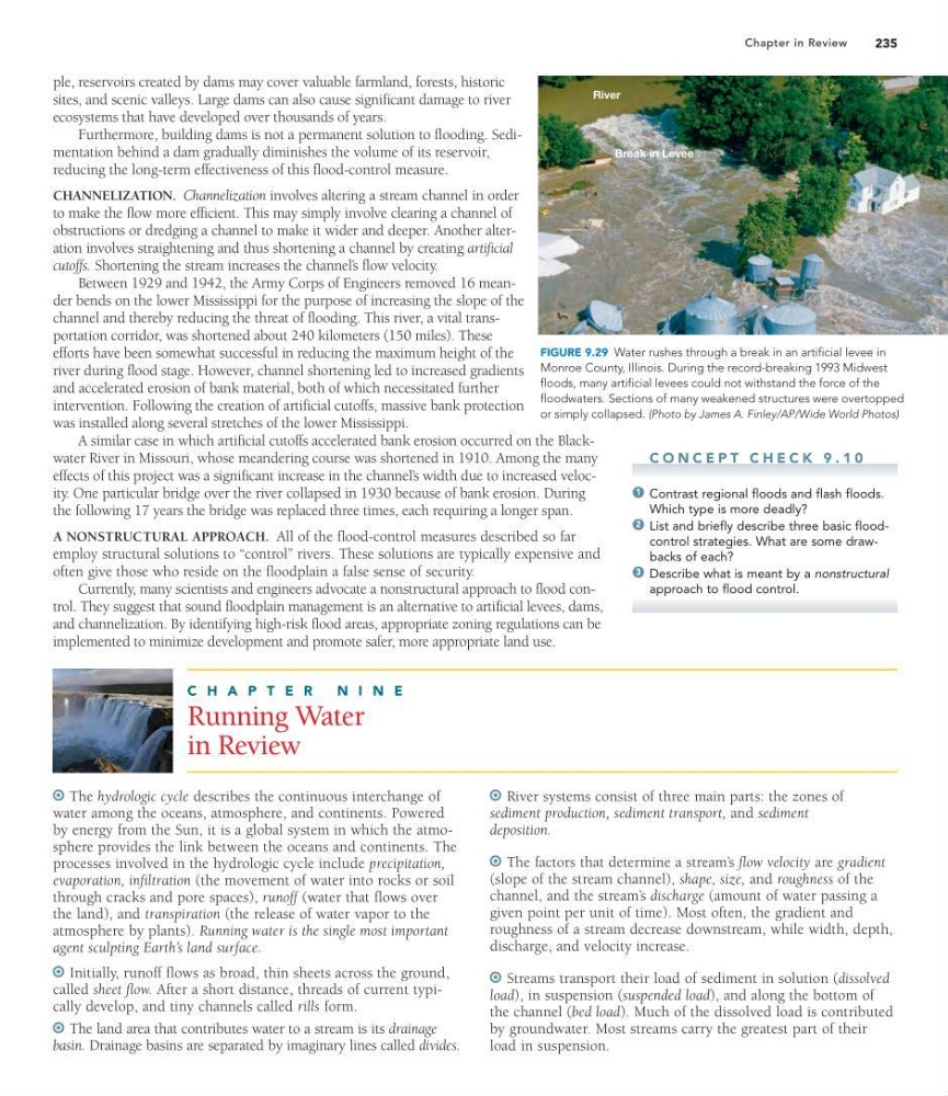
FIGURE 9.29 Water rushes through a break in an artificial levee in
Monroe County, Illinois. During the record-breaking 1993 Midwest
floods, many artificial levees could not withstand the force of the
floodwaters. Sections of many weakened structures were overtopped
or simply collapsed. (Photo by James A. Finley/AP/Wide World Photos)
C O N C E P T C H E C K 9 . 1 0
Contrast regional floods and flash floods.
Which type is more deadly?
List and briefly describe three basic floodcontrol strategies. What are some drawbacks of each?
Describe what is meant by a nonstructural
approach to flood control.
3
2
1
C H A P T E R
N I N E
Running Water
in Review
The hydrologic cycle describes the continuous interchange of
water among the oceans, atmosphere, and continents. Powered
by energy from the Sun, it is a global system in which the atmosphere provides the link between the oceans and continents. The
processes involved in the hydrologic cycle include precipitation,
evaporation, infiltration (the movement of water into rocks or soil
through cracks and pore spaces), runoff (water that flows over
the land), and transpiration (the release of water vapor to the
atmosphere by plants). Running water is the single most important
agent sculpting Earth’s land surface.
Initially, runoff flows as broad, thin sheets across the ground,
called sheet flow. After a short distance, threads of current typically develop, and tiny channels called rills form.
The land area that contributes water to a stream is its drainage
basin. Drainage basins are separated by imaginary lines called divides.
River systems consist of three main parts: the zones of
sediment production, sediment transport, and sediment
deposition.
The factors that determine a stream’ s flow velocity are gradient
(slope of the stream channel), shape, size, and roughness of the
channel, and the stream’ s discharge (amount of water passing a
given point per unit of time). Most often, the gradient and
roughness of a stream decrease downstream, while width, depth,
discharge, and velocity increase.
Streams transport their load of sediment in solution (dissolved
load), in suspension (suspended load), and along the bottom of
the channel (bed load). Much of the dissolved load is contributed
by groundwater. Most streams carry the greatest part of their
load in suspension.
Chapter in Review
ple, reservoirs created by dams may cover valuable farmland, forests, historic
sites, and scenic valleys. Large dams can also cause significant damage to river
ecosystems that have developed over thousands of years.
Furthermore, building dams is not a permanent solution to flooding. Sedimentation behind a dam gradually diminishes the volume of its reservoir,
reducing the long-term effectiveness of this flood-control measure.
CHANNELIZATION. Channelization involves altering a stream channel in order
to make the flow more efficient. This may simply involve clearing a channel of
obstructions or dredging a channel to make it wider and deeper. Another alteration involves straightening and thus shortening a channel by creating artificial
cutoffs. Shortening the stream increases the channel’ s flow velocity.
Between 1929 and 1942, the Army Corps of Engineers removed 16 meander bends on the lower Mississippi for the purpose of increasing the slope of the
channel and thereby reducing the threat of flooding. This river, a vital transportation corridor, was shortened about 240 kilometers (150 miles). These
efforts have been somewhat successful in reducing the maximum height of the
river during flood stage. However, channel shortening led to increased gradients
and accelerated erosion of bank material, both of which necessitated further
intervention. Following the creation of artificial cutoffs, massive bank protection
was installed along several stretches of the lower Mississippi.
A similar case in which artificial cutoffs accelerated bank erosion occurred on the Blackwater River in Missouri, whose meandering course was shortened in 1910. Among the many
effects of this project was a significant increase in the channel’ s width due to increased velocity. One particular bridge over the river collapsed in 1930 because of bank erosion. During
the following 17 years the bridge was replaced three times, each requiring a longer span.
A NONSTRUCTURAL APPROACH. All of the flood-control measures described so far
employ structural solutions to “control” rivers. These solutions are typically expensive and
often give those who reside on the floodplain a false sense of security.
Currently, many scientists and engineers advocate a nonstructural approach to flood control. They suggest that sound floodplain management is an alternative to artificial levees, dams,
and channelization. By identifying high-risk flood areas, appropriate zoning regulations can be
implemented to minimize development and promote safer, more appropriate land use.
River
Break in Levee
FIGURE 9.29 Water rushes through a break in an artificial levee in
Monroe County, Illinois. During the record-breaking 1993 Midwest
floods, many artificial levees could not withstand the force of the
floodwaters. Sections of many weakened structures were overtopped
or simply collapsed. (Photo by James A. Finley/AP/Wide World Photos)
C O N C E P T C H E C K 9 . 1 0
Contrast regional floods and flash floods.
Which type is more deadly?
List and briefly describe three basic floodcontrol strategies. What are some drawbacks of each?
Describe what is meant by a nonstructural
approach to flood control.
3
2
1
C H A P T E R
N I N E
Running Water
in Review
The hydrologic cycle describes the continuous interchange of
water among the oceans, atmosphere, and continents. Powered
by energy from the Sun, it is a global system in which the atmosphere provides the link between the oceans and continents. The
processes involved in the hydrologic cycle include precipitation,
evaporation, infiltration (the movement of water into rocks or soil
through cracks and pore spaces), runoff (water that flows over
the land), and transpiration (the release of water vapor to the
atmosphere by plants). Running water is the single most important
agent sculpting Earth’s land surface.
Initially, runoff flows as broad, thin sheets across the ground,
called sheet flow. After a short distance, threads of current typically develop, and tiny channels called rills form.
The land area that contributes water to a stream is its drainage
basin. Drainage basins are separated by imaginary lines called divides.
River systems consist of three main parts: the zones of
sediment production, sediment transport, and sediment
deposition.
The factors that determine a stream’ s flow velocity are gradient
(slope of the stream channel), shape, size, and roughness of the
channel, and the stream’ s discharge (amount of water passing a
given point per unit of time). Most often, the gradient and
roughness of a stream decrease downstream, while width, depth,
discharge, and velocity increase.
Streams transport their load of sediment in solution (dissolved
load), in suspension (suspended load), and along the bottom of
the channel (bed load). Much of the dissolved load is contributed
by groundwater. Most streams carry the greatest part of their
load in suspension.