

233
Floods and Flood Control
Floods and Flood
Control
Floods occur when the flow of a stream
becomes so great that it exceeds the capacity of its channel and overflows its banks
(FIGURE 9.27). Among the most deadly and
most destructive of all geologic hazards,
floods are, nevertheless, simply part of the
natural behavior of streams.
Most floods are caused by atmospheric
processes that can vary greatly in both time
and space. An hour or less of intense thunderstorm rainfall can trigger floods in small
valleys. By contrast, major floods in large
river valleys are often the result of an
extraordinary series of precipitation events
over a broad region for many days or weeks.
Land use planning in river basins
requires an understanding of the frequency
and magnitude of floods. For any particular
river, a relationship exists between the size
of a flood and the frequency with which it
occurs. The larger the flood, the less often
it is expected to occur. You have probably
heard of a 100-year flood. This describes the
recurrence interval or return period, which is
an estimate of how often a flood of a given
size can be expected to occur. A 25-year
event would be much smaller, but would
be four times more likely to occur than a
100-year flood. The relationship between
the frequency and magnitude of floods differs from one region to another. For example, in arid climates, large, 100-year floods
are typically much more extreme than
those in humid areas.
Types of Floods
Floods can be the result of several naturally
occurring and human-induced factors. Common flood types include regional floods, flash
floods, ice-jam floods, and dam-failure floods.
REGIONAL FLOODS. Most regional floods
are seasonal. Rapid melting of snow in
spring and/or heavy spring rains often
overwhelm rivers. For example, the
A. Dendritic pattern
develops on uniform
bedrock
Volcano
B. Radial pattern
develops on isolated
volcanic cones or domes
C. Rectangular pattern
develops on highly
jointed bedrock
D. Trellis pattern
develops in areas of
alternating weak and
resistant bedrock
Ridges of
resistant
rock
Valleys cut in
less-resistant
rock
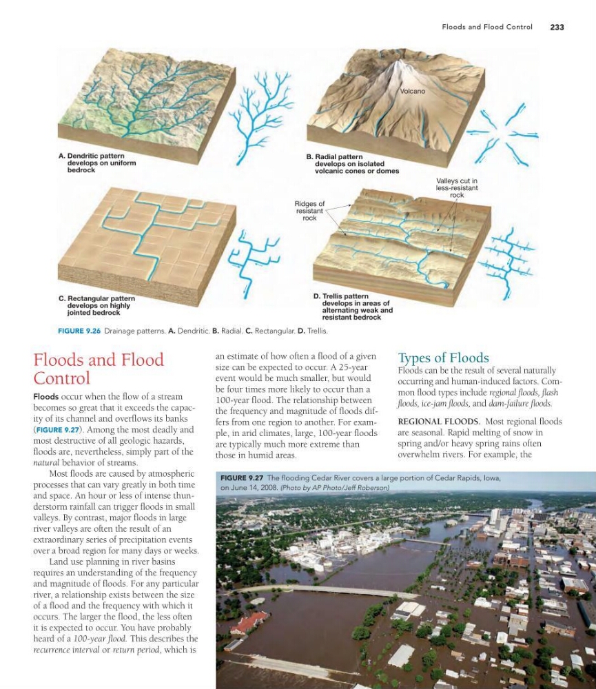
FIGURE 9.26 Drainage patterns. A. Dendritic. B. Radial. C. Rectangular. D. Trellis.
FIGURE 9.27 The flooding Cedar River covers a large portion of Cedar Rapids, Iowa,
on June 14, 2008. (Photo by AP Photo/Jeff Roberson)
Floods and Flood Control
Floods and Flood
Control
Floods occur when the flow of a stream
becomes so great that it exceeds the capacity of its channel and overflows its banks
(FIGURE 9.27). Among the most deadly and
most destructive of all geologic hazards,
floods are, nevertheless, simply part of the
natural behavior of streams.
Most floods are caused by atmospheric
processes that can vary greatly in both time
and space. An hour or less of intense thunderstorm rainfall can trigger floods in small
valleys. By contrast, major floods in large
river valleys are often the result of an
extraordinary series of precipitation events
over a broad region for many days or weeks.
Land use planning in river basins
requires an understanding of the frequency
and magnitude of floods. For any particular
river, a relationship exists between the size
of a flood and the frequency with which it
occurs. The larger the flood, the less often
it is expected to occur. You have probably
heard of a 100-year flood. This describes the
recurrence interval or return period, which is
an estimate of how often a flood of a given
size can be expected to occur. A 25-year
event would be much smaller, but would
be four times more likely to occur than a
100-year flood. The relationship between
the frequency and magnitude of floods differs from one region to another. For example, in arid climates, large, 100-year floods
are typically much more extreme than
those in humid areas.
Types of Floods
Floods can be the result of several naturally
occurring and human-induced factors. Common flood types include regional floods, flash
floods, ice-jam floods, and dam-failure floods.
REGIONAL FLOODS. Most regional floods
are seasonal. Rapid melting of snow in
spring and/or heavy spring rains often
overwhelm rivers. For example, the
A. Dendritic pattern
develops on uniform
bedrock
Volcano
B. Radial pattern
develops on isolated
volcanic cones or domes
C. Rectangular pattern
develops on highly
jointed bedrock
D. Trellis pattern
develops in areas of
alternating weak and
resistant bedrock
Ridges of
resistant
rock
Valleys cut in
less-resistant
rock
FIGURE 9.26 Drainage patterns. A. Dendritic. B. Radial. C. Rectangular. D. Trellis.
FIGURE 9.27 The flooding Cedar River covers a large portion of Cedar Rapids, Iowa,
on June 14, 2008. (Photo by AP Photo/Jeff Roberson)