

CHAPTER 9 Running Water
232
Drainage Patterns
Drainage systems are interconnected
networks of streams that form a variety of
patterns. Variances occur primarily in
response to the type of material on which
the streams developed and/or the structural
pattern of fractures, faults, and folds.
The most common, the dendritic
drainage pattern, is characterized by irregular branching of tributary streams that
resemble the branching pattern of a deciduous tree (FIGURE 9.26A). In fact, the word
dendritic means “treelike.” This drainage
pattern develops whenever underlying
bedrock is relatively uniform, such as flatlying sedimentary strata or massive igneous
rocks. Because the underlying material is
essentially uniform in its resistance to erosion, it does not control the pattern of
streamflow. Rather, the pattern is primarily
determined by the slope of land.
When streams diverge from a central
area, like spokes from the hub of a wheel, it
is called a radial drainage pattern (FIGURE
9.26B). This pattern typically develops on
isolated volcanic cones and domal uplifts.
Valley
wall
Coarse sediments
Fine sediments
Yazoo tributary
Natural
levees
Flo odp lain
Back swamp
Flo odp lain
Coarse sediments
deposited
Fine sediments
deposited
Developing
natural levee
Natural levee
Natural levee after numerous floods
Floodstage
Post flood
Floodstage
Coarse sediments
deposited
Fine sediments
deposited
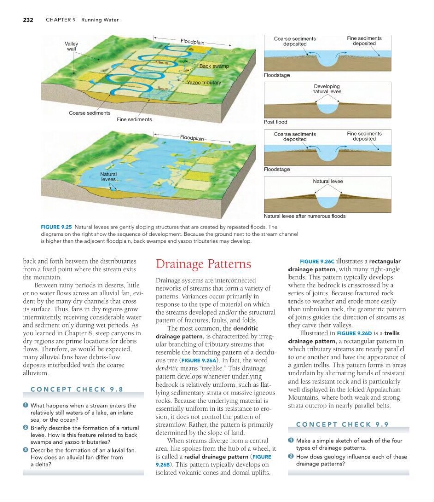
FIGURE 9.25 Natural levees are gently sloping structures that are created by repeated floods. The
diagrams on the right show the sequence of development. Because the ground next to the stream channel
is higher than the adjacent floodplain, back swamps and yazoo tributaries may develop.
back and forth between the distributaries
from a fixed point where the stream exits
the mountain.
Between rainy periods in deserts, little
or no water flows across an alluvial fan, evident by the many dry channels that cross
its surface. Thus, fans in dry regions grow
intermittently, receiving considerable water
and sediment only during wet periods. As
you learned in Chapter 8, steep canyons in
dry regions are prime locations for debris
flows. Therefore, as would be expected,
many alluvial fans have debris-flow
deposits interbedded with the coarse
alluvium.
C O N C E P T C H E C K 9 . 8
What happens when a stream enters the
relatively still waters of a lake, an inland
sea, or the ocean?
Briefly describe the formation of a natural
levee. How is this feature related to back
swamps and yazoo tributaries?
Describe the formation of an alluvial fan.
How does an alluvial fan differ from
a delta?
3
2
1
FIGURE 9.26C illustrates a rectangular
drainage pattern, with many right-angle
bends. This pattern typically develops
where the bedrock is crisscrossed by a
series of joints. Because fractured rock
tends to weather and erode more easily
than unbroken rock, the geometric pattern
of joints guides the direction of streams as
they carve their valleys.
Illustrated in FIGURE 9.26D is a trellis
drainage pattern, a rectangular pattern in
which tributary streams are nearly parallel
to one another and have the appearance of
a garden trellis. This pattern forms in areas
underlain by alternating bands of resistant
and less resistant rock and is particularly
well displayed in the folded Appalachian
Mountains, where both weak and strong
strata outcrop in nearly parallel belts.
C O N C E P T C H E C K 9 . 9
Make a simple sketch of each of the four
types of drainage patterns.
How does geology influence each of these
drainage patterns?
2
1
232
Drainage Patterns
Drainage systems are interconnected
networks of streams that form a variety of
patterns. Variances occur primarily in
response to the type of material on which
the streams developed and/or the structural
pattern of fractures, faults, and folds.
The most common, the dendritic
drainage pattern, is characterized by irregular branching of tributary streams that
resemble the branching pattern of a deciduous tree (FIGURE 9.26A). In fact, the word
dendritic means “treelike.” This drainage
pattern develops whenever underlying
bedrock is relatively uniform, such as flatlying sedimentary strata or massive igneous
rocks. Because the underlying material is
essentially uniform in its resistance to erosion, it does not control the pattern of
streamflow. Rather, the pattern is primarily
determined by the slope of land.
When streams diverge from a central
area, like spokes from the hub of a wheel, it
is called a radial drainage pattern (FIGURE
9.26B). This pattern typically develops on
isolated volcanic cones and domal uplifts.
Valley
wall
Coarse sediments
Fine sediments
Yazoo tributary
Natural
levees
Flo odp lain
Back swamp
Flo odp lain
Coarse sediments
deposited
Fine sediments
deposited
Developing
natural levee
Natural levee
Natural levee after numerous floods
Floodstage
Post flood
Floodstage
Coarse sediments
deposited
Fine sediments
deposited
FIGURE 9.25 Natural levees are gently sloping structures that are created by repeated floods. The
diagrams on the right show the sequence of development. Because the ground next to the stream channel
is higher than the adjacent floodplain, back swamps and yazoo tributaries may develop.
back and forth between the distributaries
from a fixed point where the stream exits
the mountain.
Between rainy periods in deserts, little
or no water flows across an alluvial fan, evident by the many dry channels that cross
its surface. Thus, fans in dry regions grow
intermittently, receiving considerable water
and sediment only during wet periods. As
you learned in Chapter 8, steep canyons in
dry regions are prime locations for debris
flows. Therefore, as would be expected,
many alluvial fans have debris-flow
deposits interbedded with the coarse
alluvium.
C O N C E P T C H E C K 9 . 8
What happens when a stream enters the
relatively still waters of a lake, an inland
sea, or the ocean?
Briefly describe the formation of a natural
levee. How is this feature related to back
swamps and yazoo tributaries?
Describe the formation of an alluvial fan.
How does an alluvial fan differ from
a delta?
3
2
1
FIGURE 9.26C illustrates a rectangular
drainage pattern, with many right-angle
bends. This pattern typically develops
where the bedrock is crisscrossed by a
series of joints. Because fractured rock
tends to weather and erode more easily
than unbroken rock, the geometric pattern
of joints guides the direction of streams as
they carve their valleys.
Illustrated in FIGURE 9.26D is a trellis
drainage pattern, a rectangular pattern in
which tributary streams are nearly parallel
to one another and have the appearance of
a garden trellis. This pattern forms in areas
underlain by alternating bands of resistant
and less resistant rock and is particularly
well displayed in the folded Appalachian
Mountains, where both weak and strong
strata outcrop in nearly parallel belts.
C O N C E P T C H E C K 9 . 9
Make a simple sketch of each of the four
types of drainage patterns.
How does geology influence each of these
drainage patterns?
2
1