

231
Depositional Landforms
diverted from one channel to a shorter,
more direct path to the Gulf of Mexico.
The individual subdeltas intertwine and
partially cover each other to produce a complex structure. It is also apparent from
Figure 9.24 that after each channel was
abandoned, coastal erosion modified the
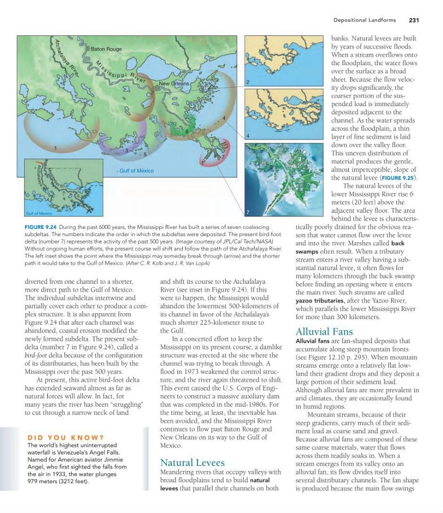
newly formed subdelta. The present subdelta (number 7 in Figure 9.24), called a
bird-foot delta because of the configuration
of its distributaries, has been built by the
Mississippi over the past 500 years.
At present, this active bird-foot delta
has extended seaward almost as far as
natural forces will allow. In fact, for
many years the river has been “struggling”
to cut through a narrow neck of land
and shift its course to the Atchafalaya
River (see inset in Figure 9.24). If this
were to happen, the Mississippi would
abandon the lowermost 500-kilometers of
its channel in favor of the Atchafalaya’ s
much shorter 225-kilometer route to
the Gulf.
In a concerted effort to keep the
Mississippi on its present course, a damlike
structure was erected at the site where the
channel was trying to break through. A
flood in 1973 weakened the control structure, and the river again threatened to shift.
This event caused the U.S. Corps of Engineers to construct a massive auxiliary dam
that was completed in the mid-1980s. For
the time being, at least, the inevitable has
been avoided, and the Mississippi River
continues to flow past Baton Rouge and
New Orleans on its way to the Gulf of
Mexico.
Natural Levees
Meandering rivers that occupy valleys with
broad floodplains tend to build natural
levees that parallel their channels on both
banks. Natural levees are built
by years of successive floods.
When a stream overflows onto
the floodplain, the water flows
over the surface as a broad
sheet. Because the flow velocity drops significantly, the
coarser portion of the suspended load is immediately
deposited adjacent to the
channel. As the water spreads
across the floodplain, a thin
layer of fine sediment is laid
down over the valley floor.
This uneven distribution of
material produces the gentle,
almost imperceptible, slope of
the natural levee (FIGURE 9.25).
The natural levees of the
lower Mississippi River rise 6
meters (20 feet) above the
adjacent valley floor. The area
behind the levee is characteristically poorly drained for the obvious reason that water cannot flow over the levee
and into the river. Marshes called back
swamps often result. When a tributary
stream enters a river valley having a substantial natural levee, it often flows for
many kilometers through the back swamp
before finding an opening where it enters
the main river. Such streams are called
yazoo tributaries, after the Yazoo River,
which parallels the lower Mississippi River
for more than 300 kilometers.
Alluvial Fans
Alluvial fans are fan-shaped deposits that
accumulate along steep mountain fronts
(see Figure 12.10 p. 295). When mountain
streams emerge onto a relatively flat lowland their gradient drops and they deposit a
large portion of their sediment load.
Although alluvial fans are more prevalent in
arid climates, they are occasionally found
in humid regions.
Mountain streams, because of their
steep gradients, carry much of their sediment load as coarse sand and gravel.
Because alluvial fans are composed of these
same coarse materials, water that flows
across them readily soaks in. When a
stream emerges from its valley onto an
alluvial fan, its flow divides itself into
several distributary channels. The fan shape
is produced because the main flow swings
Baton Rouge
New Orleans
Gulf of Mexico
Gulf of Mexico
1
2
3
4
5
6
7
Atc h a f a l a y a
R i
v e r
2
7
4
M
i s s i s s i p p i R i v e r
M
is
s
is
s
ip
p
i R .
At
chafala
y
a
R
.
FIGURE 9.24 During the past 6000 years, the Mississippi River has built a series of seven coalescing
subdeltas. The numbers indicate the order in which the subdeltas were deposited. The present bird-foot
delta (number 7) represents the activity of the past 500 years. (Image courtesy of JPL/Cal Tech/NASA)
Without ongoing human efforts, the present course will shift and follow the path of the Atchafalaya River.
The left inset shows the point where the Mississippi may someday break through (arrow) and the shorter
path it would take to the Gulf of Mexico. (After C. R. Kolb and J. R. Van Lopik)
D I D Y O U K N O W ?
The world’s highest uninterrupted
waterfall is Venezuela’s Angel Falls.
Named for American aviator Jimmie
Angel, who first sighted the falls from
the air in 1933, the water plunges
979 meters (3212 feet).
Depositional Landforms
diverted from one channel to a shorter,
more direct path to the Gulf of Mexico.
The individual subdeltas intertwine and
partially cover each other to produce a complex structure. It is also apparent from
Figure 9.24 that after each channel was
abandoned, coastal erosion modified the
newly formed subdelta. The present subdelta (number 7 in Figure 9.24), called a
bird-foot delta because of the configuration
of its distributaries, has been built by the
Mississippi over the past 500 years.
At present, this active bird-foot delta
has extended seaward almost as far as
natural forces will allow. In fact, for
many years the river has been “struggling”
to cut through a narrow neck of land
and shift its course to the Atchafalaya
River (see inset in Figure 9.24). If this
were to happen, the Mississippi would
abandon the lowermost 500-kilometers of
its channel in favor of the Atchafalaya’ s
much shorter 225-kilometer route to
the Gulf.
In a concerted effort to keep the
Mississippi on its present course, a damlike
structure was erected at the site where the
channel was trying to break through. A
flood in 1973 weakened the control structure, and the river again threatened to shift.
This event caused the U.S. Corps of Engineers to construct a massive auxiliary dam
that was completed in the mid-1980s. For
the time being, at least, the inevitable has
been avoided, and the Mississippi River
continues to flow past Baton Rouge and
New Orleans on its way to the Gulf of
Mexico.
Natural Levees
Meandering rivers that occupy valleys with
broad floodplains tend to build natural
levees that parallel their channels on both
banks. Natural levees are built
by years of successive floods.
When a stream overflows onto
the floodplain, the water flows
over the surface as a broad
sheet. Because the flow velocity drops significantly, the
coarser portion of the suspended load is immediately
deposited adjacent to the
channel. As the water spreads
across the floodplain, a thin
layer of fine sediment is laid
down over the valley floor.
This uneven distribution of
material produces the gentle,
almost imperceptible, slope of
the natural levee (FIGURE 9.25).
The natural levees of the
lower Mississippi River rise 6
meters (20 feet) above the
adjacent valley floor. The area
behind the levee is characteristically poorly drained for the obvious reason that water cannot flow over the levee
and into the river. Marshes called back
swamps often result. When a tributary
stream enters a river valley having a substantial natural levee, it often flows for
many kilometers through the back swamp
before finding an opening where it enters
the main river. Such streams are called
yazoo tributaries, after the Yazoo River,
which parallels the lower Mississippi River
for more than 300 kilometers.
Alluvial Fans
Alluvial fans are fan-shaped deposits that
accumulate along steep mountain fronts
(see Figure 12.10 p. 295). When mountain
streams emerge onto a relatively flat lowland their gradient drops and they deposit a
large portion of their sediment load.
Although alluvial fans are more prevalent in
arid climates, they are occasionally found
in humid regions.
Mountain streams, because of their
steep gradients, carry much of their sediment load as coarse sand and gravel.
Because alluvial fans are composed of these
same coarse materials, water that flows
across them readily soaks in. When a
stream emerges from its valley onto an
alluvial fan, its flow divides itself into
several distributary channels. The fan shape
is produced because the main flow swings
Baton Rouge
New Orleans
Gulf of Mexico
Gulf of Mexico
1
2
3
4
5
6
7
Atc h a f a l a y a
R i
v e r
2
7
4
M
i s s i s s i p p i R i v e r
M
is
s
is
s
ip
p
i R .
At
chafala
y
a
R
.
FIGURE 9.24 During the past 6000 years, the Mississippi River has built a series of seven coalescing
subdeltas. The numbers indicate the order in which the subdeltas were deposited. The present bird-foot
delta (number 7) represents the activity of the past 500 years. (Image courtesy of JPL/Cal Tech/NASA)
Without ongoing human efforts, the present course will shift and follow the path of the Atchafalaya River.
The left inset shows the point where the Mississippi may someday break through (arrow) and the shorter
path it would take to the Gulf of Mexico. (After C. R. Kolb and J. R. Van Lopik)
D I D Y O U K N O W ?
The world’s highest uninterrupted
waterfall is Venezuela’s Angel Falls.
Named for American aviator Jimmie
Angel, who first sighted the falls from
the air in 1933, the water plunges
979 meters (3212 feet).