

Narrow
V-shaped valley
Floodplain
well developed
A.
B.
C.
Site of erosion
T
I
M
E
Site of deposition
229
Shaping Stream Valleys
depositional as well. Depositional floodplains are produced by major fluctuations in
conditions, such as changes in base level or climate. The floodplain in California’ s
Yosemite Valley is one such feature; it was produced when a glacier gouged the
valley floor about 300 meters (1000 feet) deeper than its former level. After the
glacial ice melted, running water refilled the valley with alluvium. The
Merced River currently winds across a relatively flat floodplain that
forms much of the floor of Yosemite Valley.
Incised Meanders and Stream Terraces
We usually find streams with highly meandering courses on
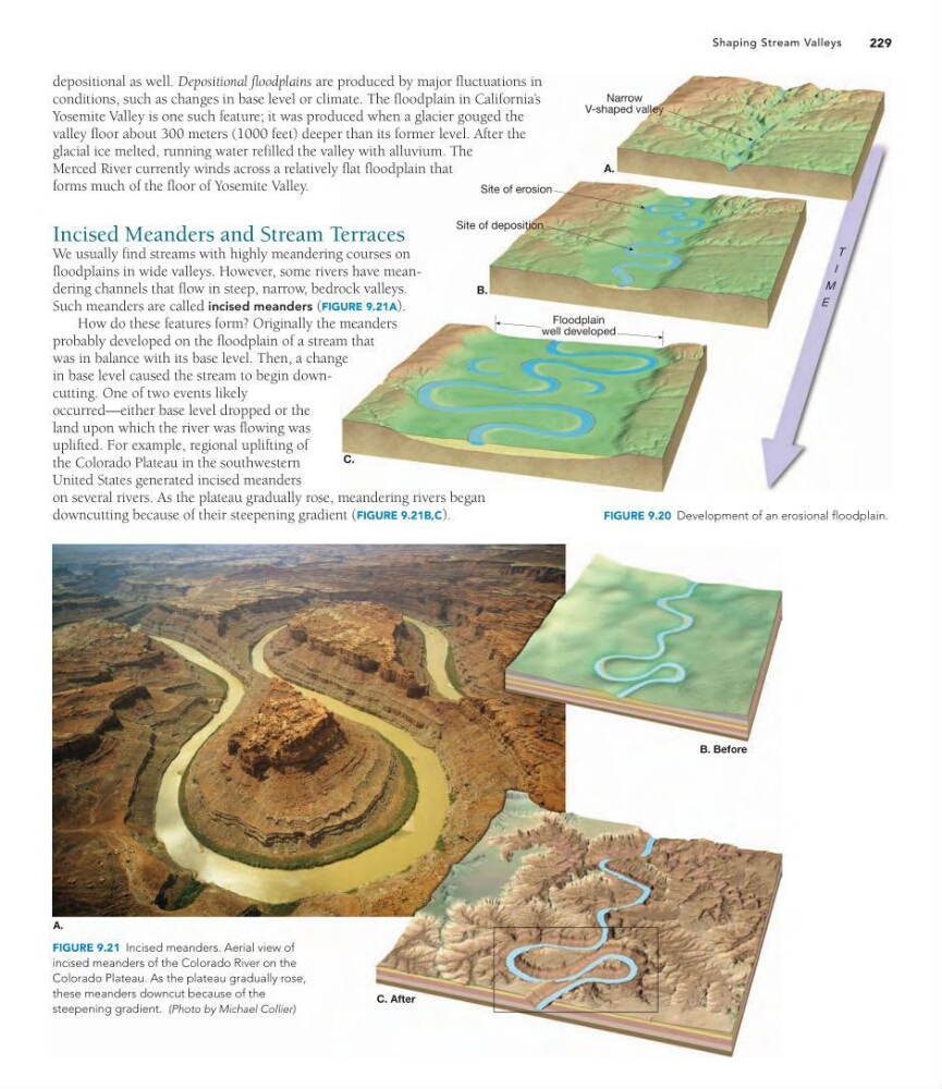
floodplains in wide valleys. However, some rivers have meandering channels that flow in steep, narrow, bedrock valleys.
Such meanders are called incised meanders (FIGURE 9.21A).
How do these features form? Originally the meanders
probably developed on the floodplain of a stream that
was in balance with its base level. Then, a change
in base level caused the stream to begin downcutting. One of two events likely
occurred—either base level dropped or the
land upon which the river was flowing was
uplifted. For example, regional uplifting of
the Colorado Plateau in the southwestern
United States generated incised meanders
on several rivers. As the plateau gradually rose, meandering rivers began
downcutting because of their steepening gradient (FIGURE 9.21B,C).
FIGURE 9.20 Development of an erosional floodplain.
A.
B. Before
C. After
FIGURE 9.21 Incised meanders. Aerial view of
incised meanders of the Colorado River on the
Colorado Plateau. As the plateau gradually rose,
these meanders downcut because of the
steepening gradient. (Photo by Michael Collier)
V-shaped valley
Floodplain
well developed
A.
B.
C.
Site of erosion
T
I
M
E
Site of deposition
229
Shaping Stream Valleys
depositional as well. Depositional floodplains are produced by major fluctuations in
conditions, such as changes in base level or climate. The floodplain in California’ s
Yosemite Valley is one such feature; it was produced when a glacier gouged the
valley floor about 300 meters (1000 feet) deeper than its former level. After the
glacial ice melted, running water refilled the valley with alluvium. The
Merced River currently winds across a relatively flat floodplain that
forms much of the floor of Yosemite Valley.
Incised Meanders and Stream Terraces
We usually find streams with highly meandering courses on
floodplains in wide valleys. However, some rivers have meandering channels that flow in steep, narrow, bedrock valleys.
Such meanders are called incised meanders (FIGURE 9.21A).
How do these features form? Originally the meanders
probably developed on the floodplain of a stream that
was in balance with its base level. Then, a change
in base level caused the stream to begin downcutting. One of two events likely
occurred—either base level dropped or the
land upon which the river was flowing was
uplifted. For example, regional uplifting of
the Colorado Plateau in the southwestern
United States generated incised meanders
on several rivers. As the plateau gradually rose, meandering rivers began
downcutting because of their steepening gradient (FIGURE 9.21B,C).
FIGURE 9.20 Development of an erosional floodplain.
A.
B. Before
C. After
FIGURE 9.21 Incised meanders. Aerial view of
incised meanders of the Colorado River on the
Colorado Plateau. As the plateau gradually rose,
these meanders downcut because of the
steepening gradient. (Photo by Michael Collier)