

CHAPTER 9 Running Water
228
temporary base level for the stream.
Because of the increased gradient, the
stream concentrates its erosive energy on
the resistant rock along an area called a
knickpoint. Eventually, the river erases the
knickpoint from its path and reestablishes a
smooth profile.
C O N C E P T C H E C K 9 . 6
Define base level.
Describe two ways base level can change.
Shaping Stream
Valleys
Running Water
Reviewing Valleys and Stream-related
Features
A stream valley consists of a channel and
the surrounding terrain that directs water
to the stream. It includes the valley floor,
which is the lower, flatter area
that is partially or totally occupied by the stream channel, and
the sloping valley walls that rise
above the valley floor on both
sides. Alluvial channels often
flow in valleys that have wide
valley floors consisting of sand
and gravel deposited in the
channel, and clay and silt
deposited by floods. Bedrock
channels, on the other hand,
tend to be located in narrow
V-shaped valleys. In some arid
regions, where weathering is
slow and rock is particularly
resistant, narrow valleys having
nearly vertical walls are also
found. Stream valleys exist on a
continuum from narrow, steepsided valleys to those that are so
flat and wide that the valley
walls are not discernable.
Streams, with the aid of
weathering and mass wasting,
shape the landscape through
which they flow. As a result,
streams continuously modify the
valleys they occupy.
GEODe
ESSENTIALS
OF GEOLOGY
2
1
Valley Deepening
When a stream’ s gradient is steep and the
channel is well above base level, downcutting is the dominant activity. Abrasion
caused by bed load sliding and rolling
along the bottom and the hydraulic power
of fast-moving water slowly lower the
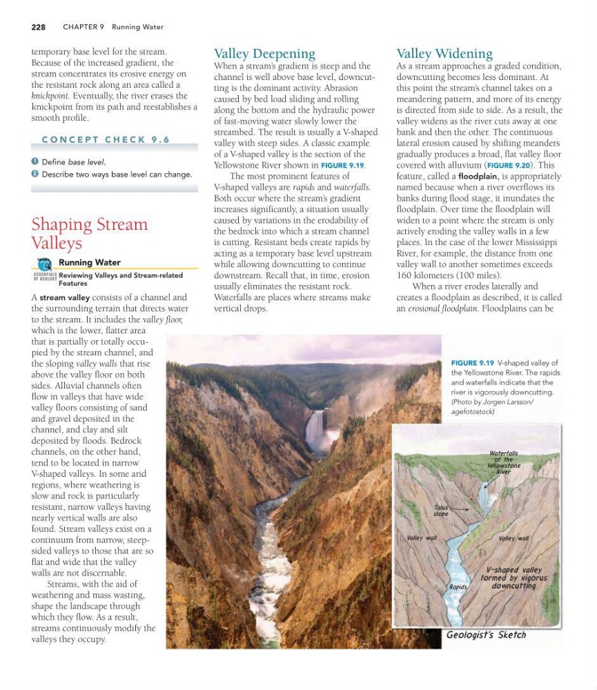
streambed. The result is usually a V-shaped
valley with steep sides. A classic example
of a V-shaped valley is the section of the
Yellowstone River shown in FIGURE 9.19.
The most prominent features of
V-shaped valleys are rapids and waterfalls.
Both occur where the stream’ s gradient
increases significantly, a situation usually
caused by variations in the erodability of
the bedrock into which a stream channel
is cutting. Resistant beds create rapids by
acting as a temporary base level upstream
while allowing downcutting to continue
downstream. Recall that, in time, erosion
usually eliminates the resistant rock.
Waterfalls are places where streams make
vertical drops.
Valley Widening
As a stream approaches a graded condition,
downcutting becomes less dominant. At
this point the stream’ s channel takes on a
meandering pattern, and more of its energy
is directed from side to side. As a result, the
valley widens as the river cuts away at one
bank and then the other. The continuous
lateral erosion caused by shifting meanders
gradually produces a broad, flat valley floor
covered with alluvium (FIGURE 9.20). This
feature, called a floodplain, is appropriately
named because when a river overflows its
banks during flood stage, it inundates the
floodplain. Over time the floodplain will
widen to a point where the stream is only
actively eroding the valley walls in a few
places. In the case of the lower Mississippi
River, for example, the distance from one
valley wall to another sometimes exceeds
160 kilometers (100 miles).
When a river erodes laterally and
creates a floodplain as described, it is called
an erosional floodplain. Floodplains can be
FIGURE 9.19 V-shaped valley of
the Yellowstone River. The rapids
and waterfalls indicate that the
river is vigorously downcutting.
(Photo by Jorgen Larsson/
agefotostock)
228
temporary base level for the stream.
Because of the increased gradient, the
stream concentrates its erosive energy on
the resistant rock along an area called a
knickpoint. Eventually, the river erases the
knickpoint from its path and reestablishes a
smooth profile.
C O N C E P T C H E C K 9 . 6
Define base level.
Describe two ways base level can change.
Shaping Stream
Valleys
Running Water
Reviewing Valleys and Stream-related
Features
A stream valley consists of a channel and
the surrounding terrain that directs water
to the stream. It includes the valley floor,
which is the lower, flatter area
that is partially or totally occupied by the stream channel, and
the sloping valley walls that rise
above the valley floor on both
sides. Alluvial channels often
flow in valleys that have wide
valley floors consisting of sand
and gravel deposited in the
channel, and clay and silt
deposited by floods. Bedrock
channels, on the other hand,
tend to be located in narrow
V-shaped valleys. In some arid
regions, where weathering is
slow and rock is particularly
resistant, narrow valleys having
nearly vertical walls are also
found. Stream valleys exist on a
continuum from narrow, steepsided valleys to those that are so
flat and wide that the valley
walls are not discernable.
Streams, with the aid of
weathering and mass wasting,
shape the landscape through
which they flow. As a result,
streams continuously modify the
valleys they occupy.
GEODe
ESSENTIALS
OF GEOLOGY
2
1
Valley Deepening
When a stream’ s gradient is steep and the
channel is well above base level, downcutting is the dominant activity. Abrasion
caused by bed load sliding and rolling
along the bottom and the hydraulic power
of fast-moving water slowly lower the
streambed. The result is usually a V-shaped
valley with steep sides. A classic example
of a V-shaped valley is the section of the
Yellowstone River shown in FIGURE 9.19.
The most prominent features of
V-shaped valleys are rapids and waterfalls.
Both occur where the stream’ s gradient
increases significantly, a situation usually
caused by variations in the erodability of
the bedrock into which a stream channel
is cutting. Resistant beds create rapids by
acting as a temporary base level upstream
while allowing downcutting to continue
downstream. Recall that, in time, erosion
usually eliminates the resistant rock.
Waterfalls are places where streams make
vertical drops.
Valley Widening
As a stream approaches a graded condition,
downcutting becomes less dominant. At
this point the stream’ s channel takes on a
meandering pattern, and more of its energy
is directed from side to side. As a result, the
valley widens as the river cuts away at one
bank and then the other. The continuous
lateral erosion caused by shifting meanders
gradually produces a broad, flat valley floor
covered with alluvium (FIGURE 9.20). This
feature, called a floodplain, is appropriately
named because when a river overflows its
banks during flood stage, it inundates the
floodplain. Over time the floodplain will
widen to a point where the stream is only
actively eroding the valley walls in a few
places. In the case of the lower Mississippi
River, for example, the distance from one
valley wall to another sometimes exceeds
160 kilometers (100 miles).
When a river erodes laterally and
creates a floodplain as described, it is called
an erosional floodplain. Floodplains can be
FIGURE 9.19 V-shaped valley of
the Yellowstone River. The rapids
and waterfalls indicate that the
river is vigorously downcutting.
(Photo by Jorgen Larsson/
agefotostock)