

floods
Zone of sediment
production
(erosion)
Zone of
transportation
Zone of
deposition
Trunk
stream
Flash flooding in Las Vegas in August 2003.
(Photo by John Locher)
FIGURE 9.6
A river system can be
divided into three zones based
on the dominant processes
operating within each zone. These are
the zones of sediment production (erosion), sediment
transport, and sediment deposition. (Adapted from
Shumm)
219
Streamflow
Mississippi
River
Drainage
Basin
Yellowstone River
Drainage
Basin
Upper
Mississippi
Lower
Mississippi
Missouri
River Basin
Yellowsto ne River
T o n g u e R iv e r
Miles City
Billings
Cody
P o w d e r R i v e r
Yellowstone
Lake
Tennessee
Ohio
River Basin
ArkansasRed-White
B B ig h o r
n
M
ts
.
B ig h o r
n
M
ts
.
B i
g h o r n
R i v e r
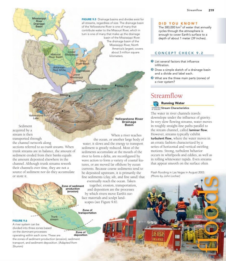
FIGURE 9.5 Drainage basins and divides exist for
all streams, regardless of size. The drainage basin
of the Yellowstone River is one of many that
contribute water to the Missouri River, which in
turn is one of many that make up the drainage
basin of the Mississippi River.
The drainage basin of the
Mississippi River, North
America’s largest, covers
about 3 million square
kilometers.
Sediment
acquired by a
stream is then
transported through
the channel network along
sections referred to as trunk streams. When
trunk streams are in balance, the amount of
sediment eroded from their banks equals
the amount deposited elsewhere in the
channel. Although trunk streams rework
their channels over time, they are not a
source of sediment nor do they accumulate
or store it.
When a river reaches
the ocean, or another large body of
water, it slows and the energy to transport
sediment is greatly reduced. Most of the
sediments accumulate at the mouth of the
river to form a delta, are reconfigured by
wave action to form a variety of coastal features, or are moved far offshore by ocean
currents. Because coarse sediments tend to
be deposited upstream, it is primarily the
fine sediments (clay, silt, and fine sand) that
eventually reach the ocean. Taken
together, erosion, transportation,
and deposition are the processes
by which rivers move Earth’ s surface materials and sculpt landscapes (see Figure 9.6).
C O N C E P T C H E C K 9 . 2
List several factors that influence
infiltration.
Draw a simple sketch of a drainage basin
and a divide and label each.
What are the three main parts (zones) of
a river system?
Streamflow
Running Water
Stream Characteristics
The water in river channels travels
downslope under the influence of gravity.
In very slow flowing streams, water moves
in roughly straight-line paths parallel to
the stream channel, called laminar flow.
However, streams typically exhibit
turbulent flow, where the water moves in
an erratic fashion characterized by a
series of horizontal and vertical swirling
motions. Strong, turbulent behavior
occurs in whirlpools and eddies, as well as
in rolling whitewater rapids. Even streams
that appear smooth on the surface often
GEODe
ESSENTIALS
OF GEOLOGY
3
2
1
D I D Y O U K N O W ?
The 380,000 km
3 of water that annually
cycles through the atmosphere is
enough to cover Earth’s surface to a
depth of about 1 meter (39 inches).
Zone of sediment
production
(erosion)
Zone of
transportation
Zone of
deposition
Trunk
stream
Flash flooding in Las Vegas in August 2003.
(Photo by John Locher)
FIGURE 9.6
A river system can be
divided into three zones based
on the dominant processes
operating within each zone. These are
the zones of sediment production (erosion), sediment
transport, and sediment deposition. (Adapted from
Shumm)
219
Streamflow
Mississippi
River
Drainage
Basin
Yellowstone River
Drainage
Basin
Upper
Mississippi
Lower
Mississippi
Missouri
River Basin
Yellowsto ne River
T o n g u e R iv e r
Miles City
Billings
Cody
P o w d e r R i v e r
Yellowstone
Lake
Tennessee
Ohio
River Basin
ArkansasRed-White
B B ig h o r
n
M
ts
.
B ig h o r
n
M
ts
.
B i
g h o r n
R i v e r
FIGURE 9.5 Drainage basins and divides exist for
all streams, regardless of size. The drainage basin
of the Yellowstone River is one of many that
contribute water to the Missouri River, which in
turn is one of many that make up the drainage
basin of the Mississippi River.
The drainage basin of the
Mississippi River, North
America’s largest, covers
about 3 million square
kilometers.
Sediment
acquired by a
stream is then
transported through
the channel network along
sections referred to as trunk streams. When
trunk streams are in balance, the amount of
sediment eroded from their banks equals
the amount deposited elsewhere in the
channel. Although trunk streams rework
their channels over time, they are not a
source of sediment nor do they accumulate
or store it.
When a river reaches
the ocean, or another large body of
water, it slows and the energy to transport
sediment is greatly reduced. Most of the
sediments accumulate at the mouth of the
river to form a delta, are reconfigured by
wave action to form a variety of coastal features, or are moved far offshore by ocean
currents. Because coarse sediments tend to
be deposited upstream, it is primarily the
fine sediments (clay, silt, and fine sand) that
eventually reach the ocean. Taken
together, erosion, transportation,
and deposition are the processes
by which rivers move Earth’ s surface materials and sculpt landscapes (see Figure 9.6).
C O N C E P T C H E C K 9 . 2
List several factors that influence
infiltration.
Draw a simple sketch of a drainage basin
and a divide and label each.
What are the three main parts (zones) of
a river system?
Streamflow
Running Water
Stream Characteristics
The water in river channels travels
downslope under the influence of gravity.
In very slow flowing streams, water moves
in roughly straight-line paths parallel to
the stream channel, called laminar flow.
However, streams typically exhibit
turbulent flow, where the water moves in
an erratic fashion characterized by a
series of horizontal and vertical swirling
motions. Strong, turbulent behavior
occurs in whirlpools and eddies, as well as
in rolling whitewater rapids. Even streams
that appear smooth on the surface often
GEODe
ESSENTIALS
OF GEOLOGY
3
2
1
D I D Y O U K N O W ?
The 380,000 km
3 of water that annually
cycles through the atmosphere is
enough to cover Earth’s surface to a
depth of about 1 meter (39 inches).