

CHAPTER 9 Running Water
218
D I D Y O U K N O W ?
North America’s largest river is the
Mississippi. South of Cairo, Illinois,
where the Ohio River joins it, the
Mississippi is more than 1 mile (1.6 km)
wide. Each year the “Mighty
Mississippi” carries about half a billion
tons of sediment to the Gulf of Mexico.
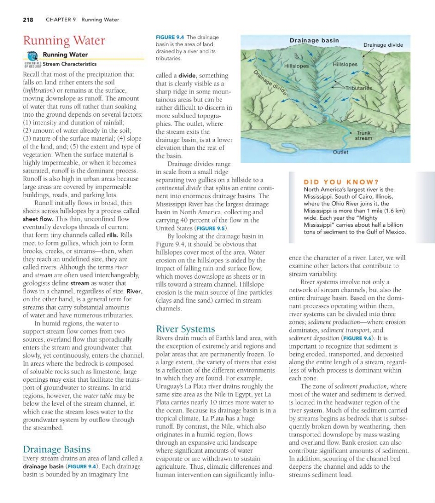
FIGURE 9.4 The drainage
basin is the area of land
drained by a river and its
tributaries.
Running Water
Running Water
Stream Characteristics
Recall that most of the precipitation that
falls on land either enters the soil
(infiltration) or remains at the surface,
moving downslope as runoff. The amount
of water that runs off rather than soaking
into the ground depends on several factors:
(1) intensity and duration of rainfall;
(2) amount of water already in the soil;
(3) nature of the surface material; (4) slope
of the land, and; (5) the extent and type of
vegetation. When the surface material is
highly impermeable, or when it becomes
saturated, runoff is the dominant process.
Runoff is also high in urban areas because
large areas are covered by impermeable
buildings, roads, and parking lots.
Runoff initially flows in broad, thin
sheets across hillslopes by a process called
sheet flow. This thin, unconfined flow
eventually develops threads of current
that form tiny channels called rills. Rills
meet to form gullies, which join to form
brooks, creeks, or streams—then, when
they reach an undefined size, they are
called rivers. Although the terms river
and stream are often used interchangeably,
geologists define stream as water that
flows in a channel, regardless of size. River,
on the other hand, is a general term for
streams that carry substantial amounts
of water and have numerous tributaries.
In humid regions, the water to
support stream flow comes from two
sources, overland flow that sporadically
enters the stream and groundwater that
slowly, yet continuously, enters the channel.
In areas where the bedrock is composed
of soluable rocks such as limestone, large
openings may exist that facilitate the transport of groundwater to streams. In arid
regions, however, the water table may be
below the level of the stream channel, in
which case the stream loses water to the
groundwater system by outflow through
the streambed.
Drainage Basins
Every stream drains an area of land called a
drainage basin (FIGURE 9.4). Each drainage
basin is bounded by an imaginary line
GEODe
ESSENTIALS
OF GEOLOGY
called a divide, something
that is clearly visible as a
sharp ridge in some mountainous areas but can be
rather difficult to discern in
more subdued topographies. The outlet, where
the stream exits the
drainage basin, is at a lower
elevation than the rest of
the basin.
Drainage divides range
in scale from a small ridge
separating two gullies on a hillside to a
continental divide that splits an entire continent into enormous drainage basins. The
Mississippi River has the largest drainage
basin in North America, collecting and
carrying 40 percent of the flow in the
United States (FIGURE 9.5).
By looking at the drainage basin in
Figure 9.4, it should be obvious that
hillslopes cover most of the area. Water
erosion on the hillslopes is aided by the
impact of falling rain and surface flow,
which moves downslope as sheets or in
rills toward a stream channel. Hillslope
erosion is the main source of fine particles
(clays and fine sand) carried in stream
channels.
River Systems
Rivers drain much of Earth’ s land area, with
the exception of extremely arid regions and
polar areas that are permanently frozen. To
a large extent, the variety of rivers that exist
is a reflection of the different environments
in which they are found. For example,
Uruguay’ s La Plata river drains roughly the
same size area as the Nile in Egypt, yet La
Plata carries nearly 10 times more water to
the ocean. Because its drainage basin is in a
tropical climate, La Plata has a huge
runoff. By contrast, the Nile, which also
originates in a humid region, flows
through an expansive arid landscape
where significant amounts of water
evaporate or are withdrawn to sustain
agriculture. Thus, climatic differences and
human intervention can significantly influDrainage basin
Drainage divide
Hillslopes
Hillslopes
Tributaries
Outlet
Trunk
stream
D
r a i n a g e d iv id
e
ence the character of a river. Later, we will
examine other factors that contribute to
stream variability.
River systems involve not only a
network of stream channels, but also the
entire drainage basin. Based on the dominant processes operating within them,
river systems can be divided into three
zones; sediment production—where erosion
dominates, sediment transport, and
sediment deposition (FIGURE 9.6). It is
important to recognize that sediment is
being eroded, transported, and deposited
along the entire length of a stream, regardless of which process is dominant within
each zone.
The zone of sediment production, where
most of the water and sediment is derived,
is located in the headwater region of the
river system. Much of the sediment carried
by streams begins as bedrock that is subsequently broken down by weathering, then
transported downslope by mass wasting
and overland flow. Bank erosion can also
contribute significant amounts of sediment.
In addition, scouring of the channel bed
deepens the channel and adds to the
stream’ s sediment load.
218
D I D Y O U K N O W ?
North America’s largest river is the
Mississippi. South of Cairo, Illinois,
where the Ohio River joins it, the
Mississippi is more than 1 mile (1.6 km)
wide. Each year the “Mighty
Mississippi” carries about half a billion
tons of sediment to the Gulf of Mexico.
FIGURE 9.4 The drainage
basin is the area of land
drained by a river and its
tributaries.
Running Water
Running Water
Stream Characteristics
Recall that most of the precipitation that
falls on land either enters the soil
(infiltration) or remains at the surface,
moving downslope as runoff. The amount
of water that runs off rather than soaking
into the ground depends on several factors:
(1) intensity and duration of rainfall;
(2) amount of water already in the soil;
(3) nature of the surface material; (4) slope
of the land, and; (5) the extent and type of
vegetation. When the surface material is
highly impermeable, or when it becomes
saturated, runoff is the dominant process.
Runoff is also high in urban areas because
large areas are covered by impermeable
buildings, roads, and parking lots.
Runoff initially flows in broad, thin
sheets across hillslopes by a process called
sheet flow. This thin, unconfined flow
eventually develops threads of current
that form tiny channels called rills. Rills
meet to form gullies, which join to form
brooks, creeks, or streams—then, when
they reach an undefined size, they are
called rivers. Although the terms river
and stream are often used interchangeably,
geologists define stream as water that
flows in a channel, regardless of size. River,
on the other hand, is a general term for
streams that carry substantial amounts
of water and have numerous tributaries.
In humid regions, the water to
support stream flow comes from two
sources, overland flow that sporadically
enters the stream and groundwater that
slowly, yet continuously, enters the channel.
In areas where the bedrock is composed
of soluable rocks such as limestone, large
openings may exist that facilitate the transport of groundwater to streams. In arid
regions, however, the water table may be
below the level of the stream channel, in
which case the stream loses water to the
groundwater system by outflow through
the streambed.
Drainage Basins
Every stream drains an area of land called a
drainage basin (FIGURE 9.4). Each drainage
basin is bounded by an imaginary line
GEODe
ESSENTIALS
OF GEOLOGY
called a divide, something
that is clearly visible as a
sharp ridge in some mountainous areas but can be
rather difficult to discern in
more subdued topographies. The outlet, where
the stream exits the
drainage basin, is at a lower
elevation than the rest of
the basin.
Drainage divides range
in scale from a small ridge
separating two gullies on a hillside to a
continental divide that splits an entire continent into enormous drainage basins. The
Mississippi River has the largest drainage
basin in North America, collecting and
carrying 40 percent of the flow in the
United States (FIGURE 9.5).
By looking at the drainage basin in
Figure 9.4, it should be obvious that
hillslopes cover most of the area. Water
erosion on the hillslopes is aided by the
impact of falling rain and surface flow,
which moves downslope as sheets or in
rills toward a stream channel. Hillslope
erosion is the main source of fine particles
(clays and fine sand) carried in stream
channels.
River Systems
Rivers drain much of Earth’ s land area, with
the exception of extremely arid regions and
polar areas that are permanently frozen. To
a large extent, the variety of rivers that exist
is a reflection of the different environments
in which they are found. For example,
Uruguay’ s La Plata river drains roughly the
same size area as the Nile in Egypt, yet La
Plata carries nearly 10 times more water to
the ocean. Because its drainage basin is in a
tropical climate, La Plata has a huge
runoff. By contrast, the Nile, which also
originates in a humid region, flows
through an expansive arid landscape
where significant amounts of water
evaporate or are withdrawn to sustain
agriculture. Thus, climatic differences and
human intervention can significantly influDrainage basin
Drainage divide
Hillslopes
Hillslopes
Tributaries
Outlet
Trunk
stream
D
r a i n a g e d iv id
e
ence the character of a river. Later, we will
examine other factors that contribute to
stream variability.
River systems involve not only a
network of stream channels, but also the
entire drainage basin. Based on the dominant processes operating within them,
river systems can be divided into three
zones; sediment production—where erosion
dominates, sediment transport, and
sediment deposition (FIGURE 9.6). It is
important to recognize that sediment is
being eroded, transported, and deposited
along the entire length of a stream, regardless of which process is dominant within
each zone.
The zone of sediment production, where
most of the water and sediment is derived,
is located in the headwater region of the
river system. Much of the sediment carried
by streams begins as bedrock that is subsequently broken down by weathering, then
transported downslope by mass wasting
and overland flow. Bank erosion can also
contribute significant amounts of sediment.
In addition, scouring of the channel bed
deepens the channel and adds to the
stream’ s sediment load.