

CHAPTER 8 Mass Wasting: The Work of Gravity
210
steep volcanic slopes, generally following
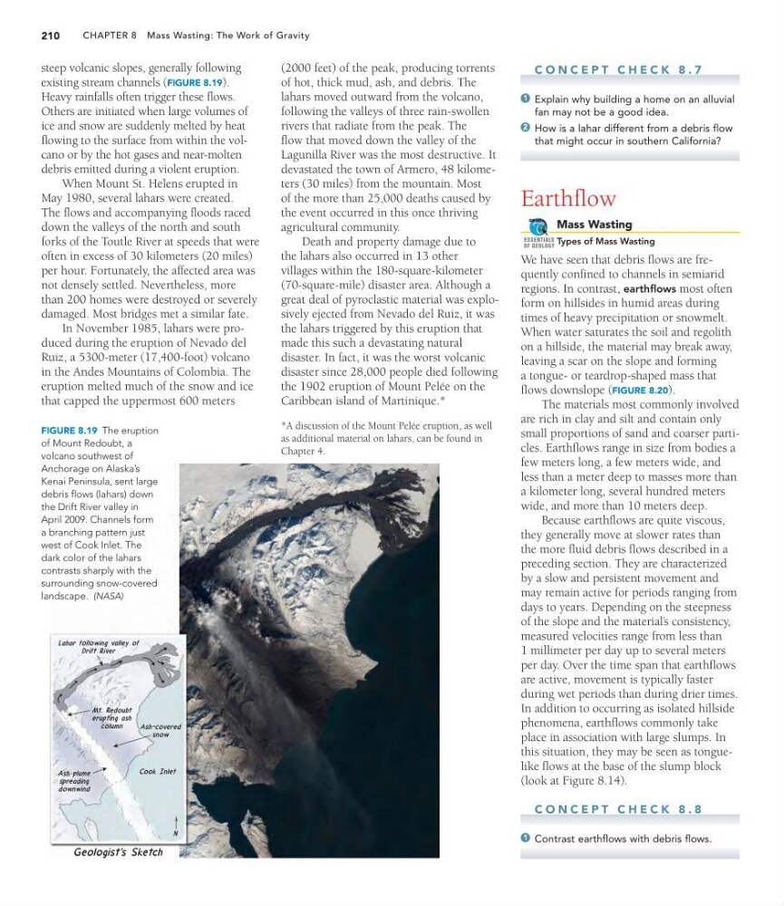
existing stream channels (FIGURE 8.19).
Heavy rainfalls often trigger these flows.
Others are initiated when large volumes of
ice and snow are suddenly melted by heat
flowing to the surface from within the volcano or by the hot gases and near-molten
debris emitted during a violent eruption.
When Mount St. Helens erupted in
May 1980, several lahars were created.
The flows and accompanying floods raced
down the valleys of the north and south
forks of the Toutle River at speeds that were
often in excess of 30 kilometers (20 miles)
per hour. Fortunately, the affected area was
not densely settled. Nevertheless, more
than 200 homes were destroyed or severely
damaged. Most bridges met a similar fate.
In November 1985, lahars were produced during the eruption of Nevado del
Ruiz, a 5300-meter (17,400-foot) volcano
in the Andes Mountains of Colombia. The
eruption melted much of the snow and ice
that capped the uppermost 600 meters
(2000 feet) of the peak, producing torrents
of hot, thick mud, ash, and debris. The
lahars moved outward from the volcano,
following the valleys of three rain-swollen
rivers that radiate from the peak. The
flow that moved down the valley of the
Lagunilla River was the most destructive. It
devastated the town of Armero, 48 kilometers (30 miles) from the mountain. Most
of the more than 25,000 deaths caused by
the event occurred in this once thriving
agricultural community.
Death and property damage due to
the lahars also occurred in 13 other
villages within the 180-square-kilometer
(70-square-mile) disaster area. Although a
great deal of pyroclastic material was explosively ejected from Nevado del Ruiz, it was
the lahars triggered by this eruption that
made this such a devastating natural
disaster. In fact, it was the worst volcanic
disaster since 28,000 people died following
the 1902 eruption of Mount Pelée on the
Caribbean island of Martinique.*
FIGURE 8.19 The eruption
of Mount Redoubt, a
volcano southwest of
Anchorage on Alaska’s
Kenai Peninsula, sent large
debris flows (lahars) down
the Drift River valley in
April 2009. Channels form
a branching pattern just
west of Cook Inlet. The
dark color of the lahars
contrasts sharply with the
surrounding snow-covered
landscape. (NASA)
*A discussion of the Mount Pelée eruption, as well
as additional material on lahars, can be found in
Chapter 4.
C O N C E P T C H E C K 8 . 7
Explain why building a home on an alluvial
fan may not be a good idea.
How is a lahar different from a debris flow
that might occur in southern California?
Earthflow
Mass Wasting
Types of Mass Wasting
We have seen that debris flows are frequently confined to channels in semiarid
regions. In contrast, earthflows most often
form on hillsides in humid areas during
times of heavy precipitation or snowmelt.
When water saturates the soil and regolith
on a hillside, the material may break away,
leaving a scar on the slope and forming
a tongue- or teardrop-shaped mass that
flows downslope (FIGURE 8.20).
The materials most commonly involved
are rich in clay and silt and contain only
small proportions of sand and coarser particles. Earthflows range in size from bodies a
few meters long, a few meters wide, and
less than a meter deep to masses more than
a kilometer long, several hundred meters
wide, and more than 10 meters deep.
Because earthflows are quite viscous,
they generally move at slower rates than
the more fluid debris flows described in a
preceding section. They are characterized
by a slow and persistent movement and
may remain active for periods ranging from
days to years. Depending on the steepness
of the slope and the material’ s consistency,
measured velocities range from less than
1 millimeter per day up to several meters
per day. Over the time span that earthflows
are active, movement is typically faster
during wet periods than during drier times.
In addition to occurring as isolated hillside
phenomena, earthflows commonly take
place in association with large slumps. In
this situation, they may be seen as tonguelike flows at the base of the slump block
(look at Figure 8.14).
C O N C E P T C H E C K 8 . 8
Contrast earthflows with debris flows.
1
GEODe
ESSENTIALS
OF GEOLOGY
2
1
210
steep volcanic slopes, generally following
existing stream channels (FIGURE 8.19).
Heavy rainfalls often trigger these flows.
Others are initiated when large volumes of
ice and snow are suddenly melted by heat
flowing to the surface from within the volcano or by the hot gases and near-molten
debris emitted during a violent eruption.
When Mount St. Helens erupted in
May 1980, several lahars were created.
The flows and accompanying floods raced
down the valleys of the north and south
forks of the Toutle River at speeds that were
often in excess of 30 kilometers (20 miles)
per hour. Fortunately, the affected area was
not densely settled. Nevertheless, more
than 200 homes were destroyed or severely
damaged. Most bridges met a similar fate.
In November 1985, lahars were produced during the eruption of Nevado del
Ruiz, a 5300-meter (17,400-foot) volcano
in the Andes Mountains of Colombia. The
eruption melted much of the snow and ice
that capped the uppermost 600 meters
(2000 feet) of the peak, producing torrents
of hot, thick mud, ash, and debris. The
lahars moved outward from the volcano,
following the valleys of three rain-swollen
rivers that radiate from the peak. The
flow that moved down the valley of the
Lagunilla River was the most destructive. It
devastated the town of Armero, 48 kilometers (30 miles) from the mountain. Most
of the more than 25,000 deaths caused by
the event occurred in this once thriving
agricultural community.
Death and property damage due to
the lahars also occurred in 13 other
villages within the 180-square-kilometer
(70-square-mile) disaster area. Although a
great deal of pyroclastic material was explosively ejected from Nevado del Ruiz, it was
the lahars triggered by this eruption that
made this such a devastating natural
disaster. In fact, it was the worst volcanic
disaster since 28,000 people died following
the 1902 eruption of Mount Pelée on the
Caribbean island of Martinique.*
FIGURE 8.19 The eruption
of Mount Redoubt, a
volcano southwest of
Anchorage on Alaska’s
Kenai Peninsula, sent large
debris flows (lahars) down
the Drift River valley in
April 2009. Channels form
a branching pattern just
west of Cook Inlet. The
dark color of the lahars
contrasts sharply with the
surrounding snow-covered
landscape. (NASA)
*A discussion of the Mount Pelée eruption, as well
as additional material on lahars, can be found in
Chapter 4.
C O N C E P T C H E C K 8 . 7
Explain why building a home on an alluvial
fan may not be a good idea.
How is a lahar different from a debris flow
that might occur in southern California?
Earthflow
Mass Wasting
Types of Mass Wasting
We have seen that debris flows are frequently confined to channels in semiarid
regions. In contrast, earthflows most often
form on hillsides in humid areas during
times of heavy precipitation or snowmelt.
When water saturates the soil and regolith
on a hillside, the material may break away,
leaving a scar on the slope and forming
a tongue- or teardrop-shaped mass that
flows downslope (FIGURE 8.20).
The materials most commonly involved
are rich in clay and silt and contain only
small proportions of sand and coarser particles. Earthflows range in size from bodies a
few meters long, a few meters wide, and
less than a meter deep to masses more than
a kilometer long, several hundred meters
wide, and more than 10 meters deep.
Because earthflows are quite viscous,
they generally move at slower rates than
the more fluid debris flows described in a
preceding section. They are characterized
by a slow and persistent movement and
may remain active for periods ranging from
days to years. Depending on the steepness
of the slope and the material’ s consistency,
measured velocities range from less than
1 millimeter per day up to several meters
per day. Over the time span that earthflows
are active, movement is typically faster
during wet periods than during drier times.
In addition to occurring as isolated hillside
phenomena, earthflows commonly take
place in association with large slumps. In
this situation, they may be seen as tonguelike flows at the base of the slump block
(look at Figure 8.14).
C O N C E P T C H E C K 8 . 8
Contrast earthflows with debris flows.
1
GEODe
ESSENTIALS
OF GEOLOGY
2
1