

Scarp created by
1995 landslide
Area outlined at
bottom of
image on left
2005
debris flow
CHAPTER 8 Mass Wasting: The Work of Gravity
204
Case Study: Landslide Hazards at La Conchita, California
Southern California lies astride a major plate boundary defined by the San Andreas Fault
and numerous other related faults that are spread across the region. It is a dynamic environment characterized by rugged mountains and steep-walled canyons. Unfortunately this scenic landscape presents serious geologic hazards. Just as tectonic forces are steadily pushing
the landscape upward, gravity is relentlessly pulling it downward. When gravity prevails,
landslides occur.
As you might expect, some of the region’ s landslides are triggered by earthquakes.
Many others, however, are related to periods of prolonged and intense rainfall. A tragic
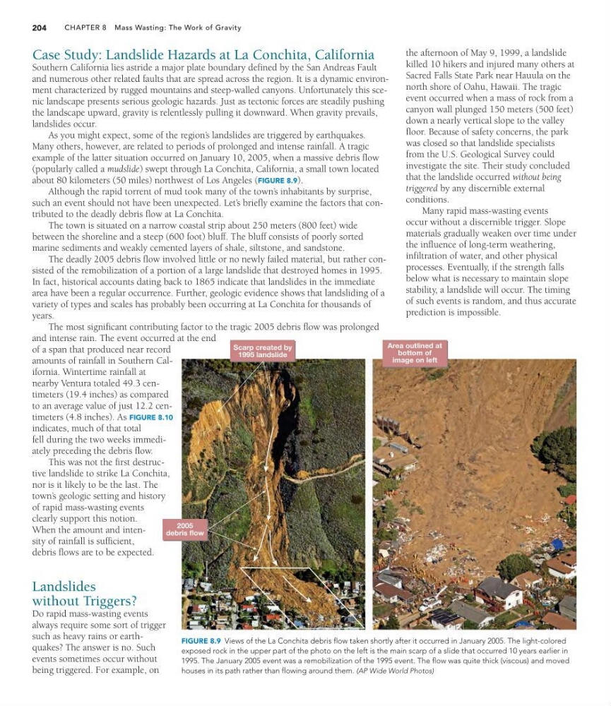
example of the latter situation occurred on January 10, 2005, when a massive debris flow
(popularly called a mudslide) swept through La Conchita, California, a small town located
about 80 kilometers (50 miles) northwest of Los Angeles (FIGURE 8.9).
Although the rapid torrent of mud took many of the town’ s inhabitants by surprise,
such an event should not have been unexpected. Let’ s briefly examine the factors that contributed to the deadly debris flow at La Conchita.
The town is situated on a narrow coastal strip about 250 meters (800 feet) wide
between the shoreline and a steep (600 foot) bluff. The bluff consists of poorly sorted
marine sediments and weakly cemented layers of shale, siltstone, and sandstone.
The deadly 2005 debris flow involved little or no newly failed material, but rather consisted of the remobilization of a portion of a large landslide that destroyed homes in 1995.
In fact, historical accounts dating back to 1865 indicate that landslides in the immediate
area have been a regular occurrence. Further, geologic evidence shows that landsliding of a
variety of types and scales has probably been occurring at La Conchita for thousands of
years.
The most significant contributing factor to the tragic 2005 debris flow was prolonged
and intense rain. The event occurred at the end
of a span that produced near record
amounts of rainfall in Southern California. Wintertime rainfall at
nearby Ventura totaled 49.3 centimeters (19.4 inches) as compared
to an average value of just 12.2 centimeters (4.8 inches). As FIGURE 8.10
indicates, much of that total
fell during the two weeks immediately preceding the debris flow.
This was not the first destructive landslide to strike La Conchita,
nor is it likely to be the last. The
town’ s geologic setting and history
of rapid mass-wasting events
clearly support this notion.
When the amount and intensity of rainfall is sufficient,
debris flows are to be expected.
Landslides
without Triggers?
Do rapid mass-wasting events
always require some sort of trigger
such as heavy rains or earthquakes? The answer is no. Such
events sometimes occur without
being triggered. For example, on
the afternoon of May 9, 1999, a landslide
killed 10 hikers and injured many others at
Sacred Falls State Park near Hauula on the
north shore of Oahu, Hawaii. The tragic
event occurred when a mass of rock from a
canyon wall plunged 150 meters (500 feet)
down a nearly vertical slope to the valley
floor. Because of safety concerns, the park
was closed so that landslide specialists
from the U.S. Geological Survey could
investigate the site. Their study concluded
that the landslide occurred without being
triggered by any discernible external
conditions.
Many rapid mass-wasting events
occur without a discernible trigger. Slope
materials gradually weaken over time under
the influence of long-term weathering,
infiltration of water, and other physical
processes. Eventually, if the strength falls
below what is necessary to maintain slope
stability, a landslide will occur. The timing
of such events is random, and thus accurate
prediction is impossible.
FIGURE 8.9 Views of the La Conchita debris flow taken shortly after it occurred in January 2005. The light-colored
exposed rock in the upper part of the photo on the left is the main scarp of a slide that occurred 10 years earlier in
1995. The January 2005 event was a remobilization of the 1995 event. The flow was quite thick (viscous) and moved
houses in its path rather than flowing around them. (AP Wide World Photos)
1995 landslide
Area outlined at
bottom of
image on left
2005
debris flow
CHAPTER 8 Mass Wasting: The Work of Gravity
204
Case Study: Landslide Hazards at La Conchita, California
Southern California lies astride a major plate boundary defined by the San Andreas Fault
and numerous other related faults that are spread across the region. It is a dynamic environment characterized by rugged mountains and steep-walled canyons. Unfortunately this scenic landscape presents serious geologic hazards. Just as tectonic forces are steadily pushing
the landscape upward, gravity is relentlessly pulling it downward. When gravity prevails,
landslides occur.
As you might expect, some of the region’ s landslides are triggered by earthquakes.
Many others, however, are related to periods of prolonged and intense rainfall. A tragic
example of the latter situation occurred on January 10, 2005, when a massive debris flow
(popularly called a mudslide) swept through La Conchita, California, a small town located
about 80 kilometers (50 miles) northwest of Los Angeles (FIGURE 8.9).
Although the rapid torrent of mud took many of the town’ s inhabitants by surprise,
such an event should not have been unexpected. Let’ s briefly examine the factors that contributed to the deadly debris flow at La Conchita.
The town is situated on a narrow coastal strip about 250 meters (800 feet) wide
between the shoreline and a steep (600 foot) bluff. The bluff consists of poorly sorted
marine sediments and weakly cemented layers of shale, siltstone, and sandstone.
The deadly 2005 debris flow involved little or no newly failed material, but rather consisted of the remobilization of a portion of a large landslide that destroyed homes in 1995.
In fact, historical accounts dating back to 1865 indicate that landslides in the immediate
area have been a regular occurrence. Further, geologic evidence shows that landsliding of a
variety of types and scales has probably been occurring at La Conchita for thousands of
years.
The most significant contributing factor to the tragic 2005 debris flow was prolonged
and intense rain. The event occurred at the end
of a span that produced near record
amounts of rainfall in Southern California. Wintertime rainfall at
nearby Ventura totaled 49.3 centimeters (19.4 inches) as compared
to an average value of just 12.2 centimeters (4.8 inches). As FIGURE 8.10
indicates, much of that total
fell during the two weeks immediately preceding the debris flow.
This was not the first destructive landslide to strike La Conchita,
nor is it likely to be the last. The
town’ s geologic setting and history
of rapid mass-wasting events
clearly support this notion.
When the amount and intensity of rainfall is sufficient,
debris flows are to be expected.
Landslides
without Triggers?
Do rapid mass-wasting events
always require some sort of trigger
such as heavy rains or earthquakes? The answer is no. Such
events sometimes occur without
being triggered. For example, on
the afternoon of May 9, 1999, a landslide
killed 10 hikers and injured many others at
Sacred Falls State Park near Hauula on the
north shore of Oahu, Hawaii. The tragic
event occurred when a mass of rock from a
canyon wall plunged 150 meters (500 feet)
down a nearly vertical slope to the valley
floor. Because of safety concerns, the park
was closed so that landslide specialists
from the U.S. Geological Survey could
investigate the site. Their study concluded
that the landslide occurred without being
triggered by any discernible external
conditions.
Many rapid mass-wasting events
occur without a discernible trigger. Slope
materials gradually weaken over time under
the influence of long-term weathering,
infiltration of water, and other physical
processes. Eventually, if the strength falls
below what is necessary to maintain slope
stability, a landslide will occur. The timing
of such events is random, and thus accurate
prediction is impossible.
FIGURE 8.9 Views of the La Conchita debris flow taken shortly after it occurred in January 2005. The light-colored
exposed rock in the upper part of the photo on the left is the main scarp of a slide that occurred 10 years earlier in
1995. The January 2005 event was a remobilization of the 1995 event. The flow was quite thick (viscous) and moved
houses in its path rather than flowing around them. (AP Wide World Photos)