

FIGURE 5.22 When it is raining, millions of
water drops are falling at velocities approaching
10 meters per second (35 kilometers per hour).
When water drops strike an exposed surface,
soil particles may splash as high as 1 meter into
the air and land more than a meter away from
the point of raindrop impact. Soil dislodged by
splash erosion is more easily moved by sheet
erosion. (Photo courtesy of U.S. Department of
Agriculture)
CHAPTER 5 Weathering and Soils
142
B.
A.
threads of current typically develop,
and tiny channels called rills begin to
form. Still deeper cuts in the soil, known
as gullies, are created as rills enlarge
(FIGURE 5.23). When normal farm cultivation cannot eliminate the channels, we
know the rills have grown large enough
to be called gullies. Although most dislodged soil particles move only a short
distance during each rainfall, substantial
quantities eventually leave the fields and
make their way downslope to a stream.
Once in the stream channel, these soil
particles, which can now be called
sediment, are transported downstream
and eventually deposited elsewhere.
Rates of Erosion
We know that soil erosion is the ultimate
fate of practically all soils. In the past, erosion occurred at slower rates than it does
today because more of the land surface was
covered and protected by trees, shrubs,
grasses, and other plants. However, human
activities such as farming, logging, and construction, which remove or disrupt the natural vegetation, have greatly accelerated the
rate of soil erosion. Without the stabilizing
effect of plants, the soil is more easily swept
away by the wind or carried downslope by
sheet wash.
Natural rates of soil erosion vary
greatly from one place to another and
depend on soil characteristics as well as
It is more difficult to measure the loss
of soil due to wind erosion. However, the
removal of soil by wind is generally much
less significant than erosion by flowing
water except during periods of prolonged
drought. When dry conditions prevail,
strong winds can remove large quantities of
soil from unprotected fields (FIGURE 5.24).
Such was the case in the 1930s. During
that period, large dust storms plagued
the Great Plains. Because of the size and
severity of these storms, the region came
to be called the Dust Bowl, and the time
period the Dirty Thirties. The heart of the
Dust Bowl was nearly 100 million acres in
the panhandles of Texas and Oklahoma
and adjacent parts of
Colorado, New
Mexico, and Kansas
(FIGURE 5.25). At times,
dust storms were so
severe that they were
called “black blizzards”
and “black rollers”
because visibility was
sometimes reduced to
only a few feet.
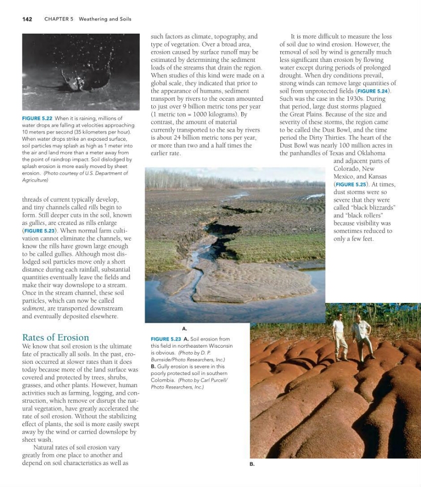
FIGURE 5.23 A. Soil erosion from
this field in northeastern Wisconsin
is obvious. (Photo by D. P.
Burnside/Photo Researchers, Inc.)
B. Gully erosion is severe in this
poorly protected soil in southern
Colombia. (Photo by Carl Purcell/
Photo Researchers, Inc.)
such factors as climate, topography, and
type of vegetation. Over a broad area,
erosion caused by surface runoff may be
estimated by determining the sediment
loads of the streams that drain the region.
When studies of this kind were made on a
global scale, they indicated that prior to
the appearance of humans, sediment
transport by rivers to the ocean amounted
to just over 9 billion metric tons per year
(1 metric ton = 1000 kilograms). By
contrast, the amount of material
currently transported to the sea by rivers
is about 24 billion metric tons per year,
or more than two and a half times the
earlier rate.
water drops are falling at velocities approaching
10 meters per second (35 kilometers per hour).
When water drops strike an exposed surface,
soil particles may splash as high as 1 meter into
the air and land more than a meter away from
the point of raindrop impact. Soil dislodged by
splash erosion is more easily moved by sheet
erosion. (Photo courtesy of U.S. Department of
Agriculture)
CHAPTER 5 Weathering and Soils
142
B.
A.
threads of current typically develop,
and tiny channels called rills begin to
form. Still deeper cuts in the soil, known
as gullies, are created as rills enlarge
(FIGURE 5.23). When normal farm cultivation cannot eliminate the channels, we
know the rills have grown large enough
to be called gullies. Although most dislodged soil particles move only a short
distance during each rainfall, substantial
quantities eventually leave the fields and
make their way downslope to a stream.
Once in the stream channel, these soil
particles, which can now be called
sediment, are transported downstream
and eventually deposited elsewhere.
Rates of Erosion
We know that soil erosion is the ultimate
fate of practically all soils. In the past, erosion occurred at slower rates than it does
today because more of the land surface was
covered and protected by trees, shrubs,
grasses, and other plants. However, human
activities such as farming, logging, and construction, which remove or disrupt the natural vegetation, have greatly accelerated the
rate of soil erosion. Without the stabilizing
effect of plants, the soil is more easily swept
away by the wind or carried downslope by
sheet wash.
Natural rates of soil erosion vary
greatly from one place to another and
depend on soil characteristics as well as
It is more difficult to measure the loss
of soil due to wind erosion. However, the
removal of soil by wind is generally much
less significant than erosion by flowing
water except during periods of prolonged
drought. When dry conditions prevail,
strong winds can remove large quantities of
soil from unprotected fields (FIGURE 5.24).
Such was the case in the 1930s. During
that period, large dust storms plagued
the Great Plains. Because of the size and
severity of these storms, the region came
to be called the Dust Bowl, and the time
period the Dirty Thirties. The heart of the
Dust Bowl was nearly 100 million acres in
the panhandles of Texas and Oklahoma
and adjacent parts of
Colorado, New
Mexico, and Kansas
(FIGURE 5.25). At times,
dust storms were so
severe that they were
called “black blizzards”
and “black rollers”
because visibility was
sometimes reduced to
only a few feet.
FIGURE 5.23 A. Soil erosion from
this field in northeastern Wisconsin
is obvious. (Photo by D. P.
Burnside/Photo Researchers, Inc.)
B. Gully erosion is severe in this
poorly protected soil in southern
Colombia. (Photo by Carl Purcell/
Photo Researchers, Inc.)
such factors as climate, topography, and
type of vegetation. Over a broad area,
erosion caused by surface runoff may be
estimated by determining the sediment
loads of the streams that drain the region.
When studies of this kind were made on a
global scale, they indicated that prior to
the appearance of humans, sediment
transport by rivers to the ocean amounted
to just over 9 billion metric tons per year
(1 metric ton = 1000 kilograms). By
contrast, the amount of material
currently transported to the sea by rivers
is about 24 billion metric tons per year,
or more than two and a half times the
earlier rate.