

Monitoring Volcanic
Activity
Today a number of volcano monitoring
techniques are employed, with most of
them aimed at detecting the movement of
magma from a subterranean reservoir (typically several kilometers deep) toward the
surface. The four most noticeable changes
in a volcanic landscape caused by the
migration of magma are: (1) changes in the
pattern of volcanic earthquakes; (2) expansion of a near-surface magma chamber,
which leads to inflation of the volcano;
(3) changes in the amount and/or composition of the gases that are released from a
volcano; and (4) an increase in ground
temperature caused by the implacement of
new magma.
Almost a third of all volcanoes that
have erupted in historic times are now
monitored using seismographs, instruments
that detect earthquake tremors. In general,
doming at Three Sisters volcanoes in
Oregon was first detected using radar
images obtained from satellites.
Volcanologists also frequently monitor
the gases that are released from volcanoes
in an effort to detect even minor changes in
their amount and/or composition. Some
volcanoes show an increase in sulfur dioxide (SO 2 ) emissions months or years prior
to an eruption. On the other hand, a few
days prior to the 1991 eruption of Mount
Pinatubo, emissions of carbon dioxide
(CO 2 ) dropped dramatically.
The development of remote sensing
devices has greatly increased our ability to
monitor volcanoes. These instruments and
techniques are particularly useful for monitoring eruptions in progress. Photographic
images and infrared (heat) sensors can
detect lava flows and volcanic columns rising from a volcano. Furthermore, satellites
can detect ground deformation as well as
monitor SO 2 emissions.
119
A.
B.
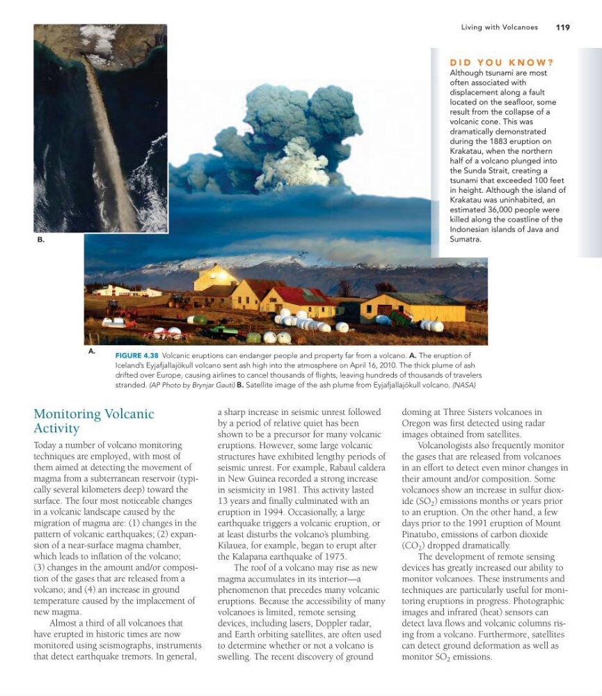
FIGURE 4.38 Volcanic eruptions can endanger people and property far from a volcano. A. The eruption of
Iceland’s Eyjafjallajökull volcano sent ash high into the atmosphere on April 16, 2010. The thick plume of ash
drifted over Europe, causing airlines to cancel thousands of flights, leaving hundreds of thousands of travelers
stranded. (AP Photo by Brynjar Gauti) B. Satellite image of the ash plume from Eyjafjallajökull volcano. (NASA)
D I D Y O U K N O W ?
Although tsunami are most
often associated with
displacement along a fault
located on the seafloor, some
result from the collapse of a
volcanic cone. This was
dramatically demonstrated
during the 1883 eruption on
Krakatau, when the northern
half of a volcano plunged into
the Sunda Strait, creating a
tsunami that exceeded 100 feet
in height. Although the island of
Krakatau was uninhabited, an
estimated 36,000 people were
killed along the coastline of the
Indonesian islands of Java and
Sumatra.
a sharp increase in seismic unrest followed
by a period of relative quiet has been
shown to be a precursor for many volcanic
eruptions. However, some large volcanic
structures have exhibited lengthy periods of
seismic unrest. For example, Rabaul caldera
in New Guinea recorded a strong increase
in seismicity in 1981. This activity lasted
13 years and finally culminated with an
eruption in 1994. Occasionally, a large
earthquake triggers a volcanic eruption, or
at least disturbs the volcano’ s plumbing.
Kilauea, for example, began to erupt after
the Kalapana earthquake of 1975.
The roof of a volcano may rise as new
magma accumulates in its interior—a
phenomenon that precedes many volcanic
eruptions. Because the accessibility of many
volcanoes is limited, remote sensing
devices, including lasers, Doppler radar,
and Earth orbiting satellites, are often used
to determine whether or not a volcano is
swelling. The recent discovery of ground
Living with Volcanoes
Activity
Today a number of volcano monitoring
techniques are employed, with most of
them aimed at detecting the movement of
magma from a subterranean reservoir (typically several kilometers deep) toward the
surface. The four most noticeable changes
in a volcanic landscape caused by the
migration of magma are: (1) changes in the
pattern of volcanic earthquakes; (2) expansion of a near-surface magma chamber,
which leads to inflation of the volcano;
(3) changes in the amount and/or composition of the gases that are released from a
volcano; and (4) an increase in ground
temperature caused by the implacement of
new magma.
Almost a third of all volcanoes that
have erupted in historic times are now
monitored using seismographs, instruments
that detect earthquake tremors. In general,
doming at Three Sisters volcanoes in
Oregon was first detected using radar
images obtained from satellites.
Volcanologists also frequently monitor
the gases that are released from volcanoes
in an effort to detect even minor changes in
their amount and/or composition. Some
volcanoes show an increase in sulfur dioxide (SO 2 ) emissions months or years prior
to an eruption. On the other hand, a few
days prior to the 1991 eruption of Mount
Pinatubo, emissions of carbon dioxide
(CO 2 ) dropped dramatically.
The development of remote sensing
devices has greatly increased our ability to
monitor volcanoes. These instruments and
techniques are particularly useful for monitoring eruptions in progress. Photographic
images and infrared (heat) sensors can
detect lava flows and volcanic columns rising from a volcano. Furthermore, satellites
can detect ground deformation as well as
monitor SO 2 emissions.
119
A.
B.
FIGURE 4.38 Volcanic eruptions can endanger people and property far from a volcano. A. The eruption of
Iceland’s Eyjafjallajökull volcano sent ash high into the atmosphere on April 16, 2010. The thick plume of ash
drifted over Europe, causing airlines to cancel thousands of flights, leaving hundreds of thousands of travelers
stranded. (AP Photo by Brynjar Gauti) B. Satellite image of the ash plume from Eyjafjallajökull volcano. (NASA)
D I D Y O U K N O W ?
Although tsunami are most
often associated with
displacement along a fault
located on the seafloor, some
result from the collapse of a
volcanic cone. This was
dramatically demonstrated
during the 1883 eruption on
Krakatau, when the northern
half of a volcano plunged into
the Sunda Strait, creating a
tsunami that exceeded 100 feet
in height. Although the island of
Krakatau was uninhabited, an
estimated 36,000 people were
killed along the coastline of the
Indonesian islands of Java and
Sumatra.
a sharp increase in seismic unrest followed
by a period of relative quiet has been
shown to be a precursor for many volcanic
eruptions. However, some large volcanic
structures have exhibited lengthy periods of
seismic unrest. For example, Rabaul caldera
in New Guinea recorded a strong increase
in seismicity in 1981. This activity lasted
13 years and finally culminated with an
eruption in 1994. Occasionally, a large
earthquake triggers a volcanic eruption, or
at least disturbs the volcano’ s plumbing.
Kilauea, for example, began to erupt after
the Kalapana earthquake of 1975.
The roof of a volcano may rise as new
magma accumulates in its interior—a
phenomenon that precedes many volcanic
eruptions. Because the accessibility of many
volcanoes is limited, remote sensing
devices, including lasers, Doppler radar,
and Earth orbiting satellites, are often used
to determine whether or not a volcano is
swelling. The recent discovery of ground
Living with Volcanoes