

CHAPTER 4 Volcanoes and Volcanic Hazards
108
Lahars: Mudflows on Active
and Inactive Cones
In addition to violent eruptions, large composite cones may generate a type of very
fluid mudflow referred to by its Indonesian
name lahar. These destructive flows occur
when volcanic debris becomes saturated
with water and rapidly moves down steep
volcanic slopes, generally following gullies
and stream valleys. Some lahars may be triggered when magma is emplaced near the
surface, causing large volumes of ice and
snow to melt. Others are generated when
heavy rains saturate weathered volcanic
deposits. Thus, lahars may occur even when
a volcano is not erupting.
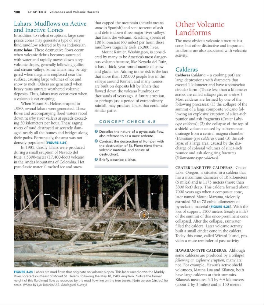
When Mount St. Helens erupted in
1980, several lahars were generated. These
flows and accompanying flood waters raced
down nearby river valleys at speeds exceeding 30 kilometers per hour. These raging
rivers of mud destroyed or severely damaged nearly all the homes and bridges along
their paths. Fortunately, the area was not
densely populated (FIGURE 4.24).
In 1985, deadly lahars were produced
during a small eruption of Nevado del
Ruiz, a 5300-meter (17,400-foot) volcano
in the Andes Mountains of Colombia. Hot
pyroclastic material melted ice and snow
Other Volcanic
Landforms
The most obvious volcanic structure is a
cone, but other distinctive and important
landforms are also associated with volcanic
activity.
Calderas
Calderas (caldaria = a cooking pot) are
large depressions with diameters that
exceed 1 kilometer and have a somewhat
circular form. (Those less than a kilometer
across are called collapse pits or craters.)
Most calderas are formed by one of the
following processes: (1) the collapse of the
summit of a large composite volcano following an explosive eruption of silica-rich
pumice and ash fragments (Crater Laketype calderas); (2) the collapse of the top of
a shield volcano caused by subterranean
drainage from a central magma chamber
(Hawaiian-type calderas); and (3) the collapse of a large area, caused by the discharge of colossal volumes of silica-rich
pumice and ash along ring fractures
(Yellowstone-type calderas).
CRATER LAKE-TYPE CALDERAS. Crater
Lake, Oregon, is situated in a caldera that
has a maximum diameter of 10 kilometers
(6 miles) and is 1175 meters (more than
3800 feet) deep. This caldera formed about
7000 years ago when a composite cone,
later named Mount Mazama, violently
extruded 50 to 70 cubic kilometers of
pyroclastic material (FIGURE 4.25). With the
loss of support, 1500 meters (nearly a mile)
of the summit of this once-prominent cone
collapsed. After the collapse, rainwater
filled the caldera. Later volcanic activity
built a small cinder cone in the caldera.
Today this cone, called Wizard Island, provides a mute reminder of past activity.
HAWAIIAN-TYPE CALDERAS. Although
some calderas are produced by a collapse
following an explosive eruption, many are
not. For example, Hawaii’ s active shield
volcanoes, Mauna Loa and Kilauea, both
have large calderas at their summits.
Kilauea’ s measures 3.3 by 4.4 kilometers
(about 2 by 3 miles) and is 150 meters
FIGURE 4.24 Lahars are mud flows that originate on volcanic slopes. This lahar raced down the Muddy
River, located southeast of Mount St. Helens, following the May 18, 1980, eruption. Notice the former
height of this fluid mud flow as recorded by the mud flow line on the tree trunks. Note person (circled) for
scale. (Photo by Lyn Topinka/U.S. Geological Survey)
that capped the mountain (nevado means
snow in Spanish) and sent torrents of ash
and debris down three major river valleys
that flank the volcano. Reaching speeds of
100 kilometers (60 miles) per hour, these
mudflows tragically took 25,000 lives.
Mount Rainier, Washington, is considered by many to be America’ s most dangerous volcano because, like Nevado del Ruiz,
it has a thick, year-round mantle of snow
and glacial ice. Adding to the risk is the fact
that more than 100,000 people live in the
valleys around Rainier, and many homes
are built on deposits left by lahars that
flowed down the volcano hundreds or
thousands of years ago. A future eruption,
or perhaps just a period of extraordinary
rainfall, may produce lahars that could take
similar paths.
C O N C E P T C H E C K 4 . 5
Describe the nature of a pyroclastic flow,
also referred to as a nuée ardente.
Contrast the destruction of Pompeii with
the destruction of St. Pierre (time frame,
volcanic material, and nature of
destruction).
Briefly describe a lahar.
3
2
1
108
Lahars: Mudflows on Active
and Inactive Cones
In addition to violent eruptions, large composite cones may generate a type of very
fluid mudflow referred to by its Indonesian
name lahar. These destructive flows occur
when volcanic debris becomes saturated
with water and rapidly moves down steep
volcanic slopes, generally following gullies
and stream valleys. Some lahars may be triggered when magma is emplaced near the
surface, causing large volumes of ice and
snow to melt. Others are generated when
heavy rains saturate weathered volcanic
deposits. Thus, lahars may occur even when
a volcano is not erupting.
When Mount St. Helens erupted in
1980, several lahars were generated. These
flows and accompanying flood waters raced
down nearby river valleys at speeds exceeding 30 kilometers per hour. These raging
rivers of mud destroyed or severely damaged nearly all the homes and bridges along
their paths. Fortunately, the area was not
densely populated (FIGURE 4.24).
In 1985, deadly lahars were produced
during a small eruption of Nevado del
Ruiz, a 5300-meter (17,400-foot) volcano
in the Andes Mountains of Colombia. Hot
pyroclastic material melted ice and snow
Other Volcanic
Landforms
The most obvious volcanic structure is a
cone, but other distinctive and important
landforms are also associated with volcanic
activity.
Calderas
Calderas (caldaria = a cooking pot) are
large depressions with diameters that
exceed 1 kilometer and have a somewhat
circular form. (Those less than a kilometer
across are called collapse pits or craters.)
Most calderas are formed by one of the
following processes: (1) the collapse of the
summit of a large composite volcano following an explosive eruption of silica-rich
pumice and ash fragments (Crater Laketype calderas); (2) the collapse of the top of
a shield volcano caused by subterranean
drainage from a central magma chamber
(Hawaiian-type calderas); and (3) the collapse of a large area, caused by the discharge of colossal volumes of silica-rich
pumice and ash along ring fractures
(Yellowstone-type calderas).
CRATER LAKE-TYPE CALDERAS. Crater
Lake, Oregon, is situated in a caldera that
has a maximum diameter of 10 kilometers
(6 miles) and is 1175 meters (more than
3800 feet) deep. This caldera formed about
7000 years ago when a composite cone,
later named Mount Mazama, violently
extruded 50 to 70 cubic kilometers of
pyroclastic material (FIGURE 4.25). With the
loss of support, 1500 meters (nearly a mile)
of the summit of this once-prominent cone
collapsed. After the collapse, rainwater
filled the caldera. Later volcanic activity
built a small cinder cone in the caldera.
Today this cone, called Wizard Island, provides a mute reminder of past activity.
HAWAIIAN-TYPE CALDERAS. Although
some calderas are produced by a collapse
following an explosive eruption, many are
not. For example, Hawaii’ s active shield
volcanoes, Mauna Loa and Kilauea, both
have large calderas at their summits.
Kilauea’ s measures 3.3 by 4.4 kilometers
(about 2 by 3 miles) and is 150 meters
FIGURE 4.24 Lahars are mud flows that originate on volcanic slopes. This lahar raced down the Muddy
River, located southeast of Mount St. Helens, following the May 18, 1980, eruption. Notice the former
height of this fluid mud flow as recorded by the mud flow line on the tree trunks. Note person (circled) for
scale. (Photo by Lyn Topinka/U.S. Geological Survey)
that capped the mountain (nevado means
snow in Spanish) and sent torrents of ash
and debris down three major river valleys
that flank the volcano. Reaching speeds of
100 kilometers (60 miles) per hour, these
mudflows tragically took 25,000 lives.
Mount Rainier, Washington, is considered by many to be America’ s most dangerous volcano because, like Nevado del Ruiz,
it has a thick, year-round mantle of snow
and glacial ice. Adding to the risk is the fact
that more than 100,000 people live in the
valleys around Rainier, and many homes
are built on deposits left by lahars that
flowed down the volcano hundreds or
thousands of years ago. A future eruption,
or perhaps just a period of extraordinary
rainfall, may produce lahars that could take
similar paths.
C O N C E P T C H E C K 4 . 5
Describe the nature of a pyroclastic flow,
also referred to as a nuée ardente.
Contrast the destruction of Pompeii with
the destruction of St. Pierre (time frame,
volcanic material, and nature of
destruction).
Briefly describe a lahar.
3
2
1