

172
5 SEDIMENTARY STRUCTURES
pointed out how foresets are sometimes oblique or perpendicular to current flow; antidunes actually point upcurrent. Paleocurrents must thus be deduced carefully from the
structures actually recorded. The sedimentary structures should be studied in the field
and their genesis considered before measurement commences. Many published studies
include compass roses of paleocurrents without making clear whether these are actual
measured structural orientations or deduced flow directions.
A further point of deducing paleocurrents from structures concerns the weighting to
be given to different structures. A ripple reflects a much more local and smaller current
flow than a dune. A dune, in turn, reflects a smaller flow than a channel. A channel may
itself meander and deviate from the regional topographic slope. The sedimentary structures are members of a hierarchy of the total flow system (Allen, 1966). Thus when
measuring paleocurrent data a channel axis is immensely more significant than a few
cross-bed orientations, and these should count for more than an equivalent number of
cross-laminae. Few geologists have attempted to address the problem of weighting sedimentary structures of different rank (Iriondo, 1973). It is, however, reassuring to find
that measurements of cross-beds in modern channels do give mean dip directions that
correspond to the channel axis (e.g., Smith, 1972; Potter and Pettijohn, 1977, p. 103).
This leads to the second main problem of paleocurrent interpretation, namely, the relationship between paleocurrent and paleoslope. In certain environments the flow systems are slope controlled, in others they are not. In the first case, paleocurrent analysis
can give valuable information on paleogeography and basin evolution. In the second
case, it cannot. Paleocurrents are slope controlled in fluvial, deltaic, and (most) turbidite environments. Paleocurrents are not related to slope in eolian and marine shoreline
environments. Klein (1967) has reviewed the relationship between sedimentary structures, paleocurrents, and paleoslopes in modern deposits. Selley (1968a) has defined a
number of regional paleocurrent models that have been recognized in ancient sedimentary deposits.
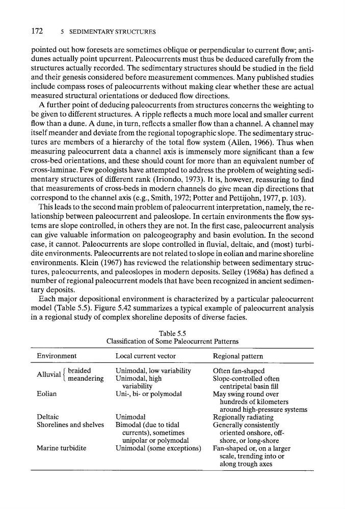
Each major depositional environment is characterized by a particular paleocurrent
model (Table 5.5). Figure 5.42 summarizes a typical example of paleocurrent analysis
in a regional study of complex shoreline deposits of diverse facies.
Table 5.5
Classification of Some Paleocurrent Patterns
Environment
Local current vector
Regional pattern
Alluvial { braided
meandering
Eolian
Deltaic
Shorelines and shelves
Marine turbidite
Unimodal, low variability
Unimodal, high
variability
Uni-, bi- or polymodal
Unimodal
Bimodal (due to tidal
currents), sometimes
unipolar or polymodal
Unimodal (some exceptions)
Often fan-shaped
Slope-controlled often
centripetal basin fill
May swing round over
hundreds of kilometers
around high-pressure systems
Regionally radiating
Generally consistently
oriented onshore, offshore, or long-shore
Fan-shaped or, on a larger
scale, trending into or
along trough axes
5 SEDIMENTARY STRUCTURES
pointed out how foresets are sometimes oblique or perpendicular to current flow; antidunes actually point upcurrent. Paleocurrents must thus be deduced carefully from the
structures actually recorded. The sedimentary structures should be studied in the field
and their genesis considered before measurement commences. Many published studies
include compass roses of paleocurrents without making clear whether these are actual
measured structural orientations or deduced flow directions.
A further point of deducing paleocurrents from structures concerns the weighting to
be given to different structures. A ripple reflects a much more local and smaller current
flow than a dune. A dune, in turn, reflects a smaller flow than a channel. A channel may
itself meander and deviate from the regional topographic slope. The sedimentary structures are members of a hierarchy of the total flow system (Allen, 1966). Thus when
measuring paleocurrent data a channel axis is immensely more significant than a few
cross-bed orientations, and these should count for more than an equivalent number of
cross-laminae. Few geologists have attempted to address the problem of weighting sedimentary structures of different rank (Iriondo, 1973). It is, however, reassuring to find
that measurements of cross-beds in modern channels do give mean dip directions that
correspond to the channel axis (e.g., Smith, 1972; Potter and Pettijohn, 1977, p. 103).
This leads to the second main problem of paleocurrent interpretation, namely, the relationship between paleocurrent and paleoslope. In certain environments the flow systems are slope controlled, in others they are not. In the first case, paleocurrent analysis
can give valuable information on paleogeography and basin evolution. In the second
case, it cannot. Paleocurrents are slope controlled in fluvial, deltaic, and (most) turbidite environments. Paleocurrents are not related to slope in eolian and marine shoreline
environments. Klein (1967) has reviewed the relationship between sedimentary structures, paleocurrents, and paleoslopes in modern deposits. Selley (1968a) has defined a
number of regional paleocurrent models that have been recognized in ancient sedimentary deposits.
Each major depositional environment is characterized by a particular paleocurrent
model (Table 5.5). Figure 5.42 summarizes a typical example of paleocurrent analysis
in a regional study of complex shoreline deposits of diverse facies.
Table 5.5
Classification of Some Paleocurrent Patterns
Environment
Local current vector
Regional pattern
Alluvial { braided
meandering
Eolian
Deltaic
Shorelines and shelves
Marine turbidite
Unimodal, low variability
Unimodal, high
variability
Uni-, bi- or polymodal
Unimodal
Bimodal (due to tidal
currents), sometimes
unipolar or polymodal
Unimodal (some exceptions)
Often fan-shaped
Slope-controlled often
centripetal basin fill
May swing round over
hundreds of kilometers
around high-pressure systems
Regionally radiating
Generally consistently
oriented onshore, offshore, or long-shore
Fan-shaped or, on a larger
scale, trending into or
along trough axes