

Groundwater for Sustainable Development 11 (2020) 100481
8
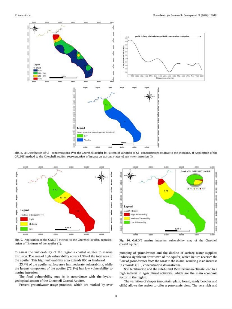
to assess the vulnerability of the region’s coastal aquifer to marine
intrusion. The area of high vulnerability covers 4.5% of the total area of
the aquifer. This high vulnerability area extends 800 m landward.
23.4% of the aquifer surface area has moderate vulnerability, while
the largest component of the aquifer (72.1%) has low vulnerability to
marine intrusion.
The final vulnerability map is in accordance with the hydrogeological system of the Cherchell Coastal Aquifer.
Present groundwater usage practices, which are marked by over
pumping of groundwater and the decline of surface water supplies;
induce a significant drawdown of the aquifer, which in turn reverses the
flow of groundwater from the coast to the inland, resulting in an increase
in chloride (Cl
−
) concentration downstream.
Soil fertilization and the sub-humid Mediterranean climate lead to a
high interest in agricultural activities, which are the main economic
sector in the region.
The variation of shapes (mountain, plain, forest, sandy beaches and
cliffs) allows the region to offer a panoramic view. The very rich and
Fig. 8. a: Distribution of Cl
−
concentrations over the Cherchell aquifer b: Pattern of variation of Cl
−
concentrations relative to the shoreline. c: Application of the
GALDIT method to the Cherchell aquifer, representation of Impact on existing status of sea water intrusion (I).
Fig. 9. Application of the GALDIT method to the Cherchell aquifer, representation of Thickness of the aquifer (T).
Fig. 10. GALDIT marine intrusion vulnerability map of the Cherchell
coastal aquifer.
N. Amarni et al.
8
to assess the vulnerability of the region’s coastal aquifer to marine
intrusion. The area of high vulnerability covers 4.5% of the total area of
the aquifer. This high vulnerability area extends 800 m landward.
23.4% of the aquifer surface area has moderate vulnerability, while
the largest component of the aquifer (72.1%) has low vulnerability to
marine intrusion.
The final vulnerability map is in accordance with the hydrogeological system of the Cherchell Coastal Aquifer.
Present groundwater usage practices, which are marked by over
pumping of groundwater and the decline of surface water supplies;
induce a significant drawdown of the aquifer, which in turn reverses the
flow of groundwater from the coast to the inland, resulting in an increase
in chloride (Cl
−
) concentration downstream.
Soil fertilization and the sub-humid Mediterranean climate lead to a
high interest in agricultural activities, which are the main economic
sector in the region.
The variation of shapes (mountain, plain, forest, sandy beaches and
cliffs) allows the region to offer a panoramic view. The very rich and
Fig. 8. a: Distribution of Cl
−
concentrations over the Cherchell aquifer b: Pattern of variation of Cl
−
concentrations relative to the shoreline. c: Application of the
GALDIT method to the Cherchell aquifer, representation of Impact on existing status of sea water intrusion (I).
Fig. 9. Application of the GALDIT method to the Cherchell aquifer, representation of Thickness of the aquifer (T).
Fig. 10. GALDIT marine intrusion vulnerability map of the Cherchell
coastal aquifer.
N. Amarni et al.