

Groundwater for Sustainable Development 11 (2020) 100481
6
- Importance Level: Each of the indicators is subdivided into variables according to the specified attributes to determine the relative
importance of the variable in question on the marine intrusion process. Importance scores range from 2.5 to 10. A high importance
score indicates a high vulnerability to marine intrusion (Chachadi
and Lobo Ferreira, 2007).
- Decision Criteria: The total sum of individual indicator scores
resulting from multiplying the importance rating values by the corresponding indicator weights, then dividing the sum obtained by the
sum of the weights used, which is 15. Higher importance values of
the variable correspond to aquifers that are more vulnerable to marine intrusion (Chachadi and Lobo Ferreira, 2007).
This GI vulnerability index of coastal aquifers to marine intrusion
according to the formula of (Chachadi and Lobo Ferreira, 2007) is as
follows
IG =
1G + 3A + 4L + 4D + 1I + 2T
15
Once the GALDIT index is calculated, it is possible to identify the
area’s most probably sensitive to marine intrusion in relation to each
other. The GALDIT index values range from 2.5 to 10. The higher values
indicate that the potential for marine intrusion is high (Chachadi and
Lobo Ferreira, 2007).
- GI < 5: Low vulnerability;
- 5 < GI < 7.5: Moderate vulnerability;
- GI > 7.5: High vulnerability.
The GIS software Arcgis 10.2 was used for the realization of the
various vulnerability maps for each parameter and the final vulnerability map due to the combination of the six parameters.
5. Results
The six parameters of the GALDIT index were calculated to determine the vulnerability of the Cherchell aquifer to marine intrusion.
Various maps were developed.
5.1. Groundwater occurrence (G)
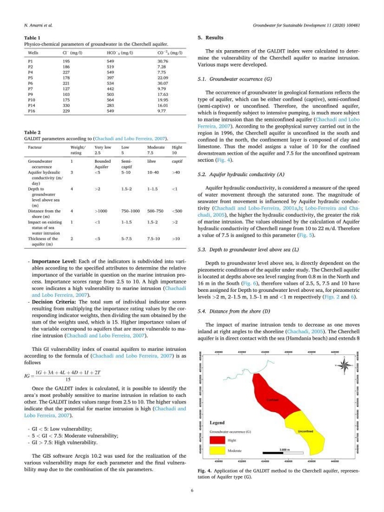
The occurrence of groundwater in geological formations reflects the
type of aquifer, which can be either confined (captive), semi-confined
(semi-captive) or unconfined. Therefore, the unconfined aquifer,
which is frequently subject to intensive pumping, is much more subject
to marine intrusion than the semiconfined aquifer (Chachadi and Lobo
Ferreira, 2007). According to the geophysical survey carried out in the
region in 1996, the Cherchell aquifer is unconfined in the south and
confined in the north, the confinement layer is composed of clay and
limestone. Thus the model assigns a value of 10 for the confined
downstream section of the aquifer and 7.5 for the unconfined upstream
section (Fig. 4).
5.2. Aquifer hydraulic conductivity (A)
Aquifer hydraulic conductivity, is considered a measure of the speed
of water movement through the saturated zone. The magnitude of
seawater front movement is influenced by Aquifer hydraulic conductivity (Chachadi and Lobo-Ferreira, 2001a,b; Lobo-Ferreira and Chachadi, 2005), the higher the hydraulic conductivity, the greater the risk
of marine intrusion. The values obtained by the calculation of Aquifer
hydraulic conductivity of Cherchell range from 10 to 22 m/d. Therefore
a value of 7.5 is assigned to this parameter (Fig. 5).
5.3. Depth to groundwater level above sea (L)
Depth to groundwater level above sea, is directly dependent on the
piezometric conditions of the aquifer under study. The Cherchell aquifer
is located at depths above sea level ranging from 0.8 m in the North and
16 m in the South (Fig. 6), therefore values of 2.5, 5, 7.5 and 10 have
been assigned for Depth to groundwater level above sea, for piezometric
levels >2 m, 2–1.5 m, 1.5–1 m and <1 m respectively (Figs. 2 and 6).
5.4. Distance from the shore (D)
The impact of marine intrusion tends to decrease as one moves
inland at right angles to the shoreline (Chachadi, 2005). The Cherchell
aquifer is in direct contact with the sea (Hamdania beach) and extends 8
Table 1
Physico-chemical parameters of groundwater in the Cherchell aquifer.
Wells
Cl
− (mg/l)
HCO
− 3 (mg/l)
CO
− 2
3 (mg/l)
P1
195
549
30.76
P2
186
519
7.28
P4
227
549
7.75
P5
178
397
22.09
P6
221
534
30.07
P7
127
442
9.79
P9
103
503
17.63
P10
175
564
19.95
P14
330
283
16.01
P16
229
549
9.77
Table 2
GALDIT parameters according to (Chachadi and Lobo Ferreira, 2007).
Facteur
Weight/
rating
Very low
2.5
Low
5
Moderate
7.5
Hight
10
Groundwater
occurrence
1
Bounded
Aquifer
Semicaptif
libre
captif
Aquifer hydraulic
conductivity (m/
day)
3
<5
5–10
10–40
>40
Depth to
groundwater
level above sea
(m)
4
>2
1.5–2
1–1.5
<1
Distance from the
shore (m)
4
>1000
750–1000
500–750
<500
Impact on existing
status of sea
water intrusion
1
<1
1–1.5
1.5–2
>2
Thickness of the
aquifer (m)
2
<5
5–7.5
7.5–10
>10
Fig. 4. Application of the GALDIT method to the Cherchell aquifer, representation of Aquifer type (G).
N. Amarni et al.
6
- Importance Level: Each of the indicators is subdivided into variables according to the specified attributes to determine the relative
importance of the variable in question on the marine intrusion process. Importance scores range from 2.5 to 10. A high importance
score indicates a high vulnerability to marine intrusion (Chachadi
and Lobo Ferreira, 2007).
- Decision Criteria: The total sum of individual indicator scores
resulting from multiplying the importance rating values by the corresponding indicator weights, then dividing the sum obtained by the
sum of the weights used, which is 15. Higher importance values of
the variable correspond to aquifers that are more vulnerable to marine intrusion (Chachadi and Lobo Ferreira, 2007).
This GI vulnerability index of coastal aquifers to marine intrusion
according to the formula of (Chachadi and Lobo Ferreira, 2007) is as
follows
IG =
1G + 3A + 4L + 4D + 1I + 2T
15
Once the GALDIT index is calculated, it is possible to identify the
area’s most probably sensitive to marine intrusion in relation to each
other. The GALDIT index values range from 2.5 to 10. The higher values
indicate that the potential for marine intrusion is high (Chachadi and
Lobo Ferreira, 2007).
- GI < 5: Low vulnerability;
- 5 < GI < 7.5: Moderate vulnerability;
- GI > 7.5: High vulnerability.
The GIS software Arcgis 10.2 was used for the realization of the
various vulnerability maps for each parameter and the final vulnerability map due to the combination of the six parameters.
5. Results
The six parameters of the GALDIT index were calculated to determine the vulnerability of the Cherchell aquifer to marine intrusion.
Various maps were developed.
5.1. Groundwater occurrence (G)
The occurrence of groundwater in geological formations reflects the
type of aquifer, which can be either confined (captive), semi-confined
(semi-captive) or unconfined. Therefore, the unconfined aquifer,
which is frequently subject to intensive pumping, is much more subject
to marine intrusion than the semiconfined aquifer (Chachadi and Lobo
Ferreira, 2007). According to the geophysical survey carried out in the
region in 1996, the Cherchell aquifer is unconfined in the south and
confined in the north, the confinement layer is composed of clay and
limestone. Thus the model assigns a value of 10 for the confined
downstream section of the aquifer and 7.5 for the unconfined upstream
section (Fig. 4).
5.2. Aquifer hydraulic conductivity (A)
Aquifer hydraulic conductivity, is considered a measure of the speed
of water movement through the saturated zone. The magnitude of
seawater front movement is influenced by Aquifer hydraulic conductivity (Chachadi and Lobo-Ferreira, 2001a,b; Lobo-Ferreira and Chachadi, 2005), the higher the hydraulic conductivity, the greater the risk
of marine intrusion. The values obtained by the calculation of Aquifer
hydraulic conductivity of Cherchell range from 10 to 22 m/d. Therefore
a value of 7.5 is assigned to this parameter (Fig. 5).
5.3. Depth to groundwater level above sea (L)
Depth to groundwater level above sea, is directly dependent on the
piezometric conditions of the aquifer under study. The Cherchell aquifer
is located at depths above sea level ranging from 0.8 m in the North and
16 m in the South (Fig. 6), therefore values of 2.5, 5, 7.5 and 10 have
been assigned for Depth to groundwater level above sea, for piezometric
levels >2 m, 2–1.5 m, 1.5–1 m and <1 m respectively (Figs. 2 and 6).
5.4. Distance from the shore (D)
The impact of marine intrusion tends to decrease as one moves
inland at right angles to the shoreline (Chachadi, 2005). The Cherchell
aquifer is in direct contact with the sea (Hamdania beach) and extends 8
Table 1
Physico-chemical parameters of groundwater in the Cherchell aquifer.
Wells
Cl
− (mg/l)
HCO
− 3 (mg/l)
CO
− 2
3 (mg/l)
P1
195
549
30.76
P2
186
519
7.28
P4
227
549
7.75
P5
178
397
22.09
P6
221
534
30.07
P7
127
442
9.79
P9
103
503
17.63
P10
175
564
19.95
P14
330
283
16.01
P16
229
549
9.77
Table 2
GALDIT parameters according to (Chachadi and Lobo Ferreira, 2007).
Facteur
Weight/
rating
Very low
2.5
Low
5
Moderate
7.5
Hight
10
Groundwater
occurrence
1
Bounded
Aquifer
Semicaptif
libre
captif
Aquifer hydraulic
conductivity (m/
day)
3
<5
5–10
10–40
>40
Depth to
groundwater
level above sea
(m)
4
>2
1.5–2
1–1.5
<1
Distance from the
shore (m)
4
>1000
750–1000
500–750
<500
Impact on existing
status of sea
water intrusion
1
<1
1–1.5
1.5–2
>2
Thickness of the
aquifer (m)
2
<5
5–7.5
7.5–10
>10
Fig. 4. Application of the GALDIT method to the Cherchell aquifer, representation of Aquifer type (G).
N. Amarni et al.