

66
Chapter 3 Getting Your Data to Match the Map
6. Type the following coordinates and then click on Zoom In to move the
view to YSU:
a Latitude: 41.10687400
a Longitude: –80.64670900
7. The crosshairs in the image will center in northeast Ohio. Press the
Virtual Earth Position’s Zoom In button several times to zoom in to
YSU’s campus (Zoom Level 17 is probably a good starting point).
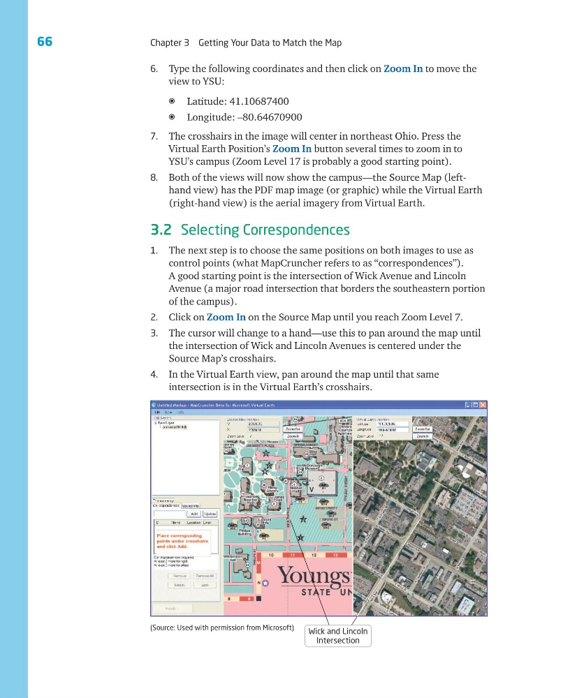
8. Both of the views will now show the campus—the Source Map (lefthand view) has the PDF map image (or graphic) while the Virtual Earth
(right-hand view) is the aerial imagery from Virtual Earth.
3.2 Selecting Correspondences
1. The next step is to choose the same positions on both images to use as
control points (what MapCruncher refers to as “correspondences”).
A good starting point is the intersection of Wick Avenue and Lincoln
Avenue (a major road intersection that borders the southeastern portion
of the campus).
2. Click on Zoom In on the Source Map until you reach Zoom Level 7.
3. The cursor will change to a hand—use this to pan around the map until
the intersection of Wick and Lincoln Avenues is centered under the
Source Map’s crosshairs.
4. In the Virtual Earth view, pan around the map until that same
intersection is in the Virtual Earth’s crosshairs.
Wick and Lincoln
Intersection
(Source: Used with permission from Microsoft)
Chapter 3 Getting Your Data to Match the Map
6. Type the following coordinates and then click on Zoom In to move the
view to YSU:
a Latitude: 41.10687400
a Longitude: –80.64670900
7. The crosshairs in the image will center in northeast Ohio. Press the
Virtual Earth Position’s Zoom In button several times to zoom in to
YSU’s campus (Zoom Level 17 is probably a good starting point).
8. Both of the views will now show the campus—the Source Map (lefthand view) has the PDF map image (or graphic) while the Virtual Earth
(right-hand view) is the aerial imagery from Virtual Earth.
3.2 Selecting Correspondences
1. The next step is to choose the same positions on both images to use as
control points (what MapCruncher refers to as “correspondences”).
A good starting point is the intersection of Wick Avenue and Lincoln
Avenue (a major road intersection that borders the southeastern portion
of the campus).
2. Click on Zoom In on the Source Map until you reach Zoom Level 7.
3. The cursor will change to a hand—use this to pan around the map until
the intersection of Wick and Lincoln Avenues is centered under the
Source Map’s crosshairs.
4. In the Virtual Earth view, pan around the map until that same
intersection is in the Virtual Earth’s crosshairs.
Wick and Lincoln
Intersection
(Source: Used with permission from Microsoft)