

59
How Is Data Transformed to a Georeferenced Format?
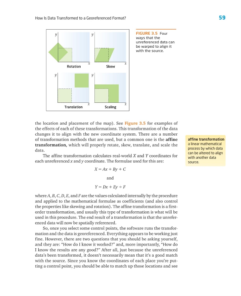
the location and placement of the map). See Figure 3.5 for examples of
the effects of each of these transformations. This transformation of the data
changes it to align with the new coordinate system. There are a number
of transformation methods that are used, but a common one is the affine
transformation, which will properly rotate, skew, translate, and scale the
data.
The affine transformation calculates real-world X and Y coordinates for
each unreferenced x and y coordinate. The formulae used for this are:
X ϭ Ax ϩ By ϩ C
and
Y ϭ Dx ϩ Ey ϩ F
where A, B, C, D, E, and F are the values calculated internally by the procedure
and applied to the mathematical formulae as coefficients (and also control
the properties like skewing and rotation). The affine transformation is a firstorder transformation, and usually this type of transformation is what will be
used in this procedure. The end result of a transformation is that the unreferenced data will now be spatially referenced.
So, once you select some control points, the software runs the transformation and the data is georeferenced. Everything appears to be working just
fine. However, there are two questions that you should be asking yourself,
and they are: “How do I know it worked?” and, more importantly, “How do
I know the results are any good?” After all, just because the unreferenced
data’s been transformed, it doesn’t necessarily mean that it’s a good match
with the source. Since you know the coordinates of each place you’re putting a control point, you should be able to match up those locations and see
affine transformation
a linear mathematical
process by which data
can be altered to align
with another data
source.
FIGURE 3.5 Four
ways that the
unreferenced data can
be warped to align it
with the source.
Scaling
y
x
Rotation
y
x
Translation
y
x
Skew
y
x
How Is Data Transformed to a Georeferenced Format?
the location and placement of the map). See Figure 3.5 for examples of
the effects of each of these transformations. This transformation of the data
changes it to align with the new coordinate system. There are a number
of transformation methods that are used, but a common one is the affine
transformation, which will properly rotate, skew, translate, and scale the
data.
The affine transformation calculates real-world X and Y coordinates for
each unreferenced x and y coordinate. The formulae used for this are:
X ϭ Ax ϩ By ϩ C
and
Y ϭ Dx ϩ Ey ϩ F
where A, B, C, D, E, and F are the values calculated internally by the procedure
and applied to the mathematical formulae as coefficients (and also control
the properties like skewing and rotation). The affine transformation is a firstorder transformation, and usually this type of transformation is what will be
used in this procedure. The end result of a transformation is that the unreferenced data will now be spatially referenced.
So, once you select some control points, the software runs the transformation and the data is georeferenced. Everything appears to be working just
fine. However, there are two questions that you should be asking yourself,
and they are: “How do I know it worked?” and, more importantly, “How do
I know the results are any good?” After all, just because the unreferenced
data’s been transformed, it doesn’t necessarily mean that it’s a good match
with the source. Since you know the coordinates of each place you’re putting a control point, you should be able to match up those locations and see
affine transformation
a linear mathematical
process by which data
can be altered to align
with another data
source.
FIGURE 3.5 Four
ways that the
unreferenced data can
be warped to align it
with the source.
Scaling
y
x
Rotation
y
x
Translation
y
x
Skew
y
x