

43
What Is SPCS?
version, states using the Transverse Mercator format have their zone’s origin 500,000 feet to the west of the principal meridian, while states using
the Lambert Conformal Conic projection have their zone’s origin 2,000,000
feet to the west of the meridian. Coordinates are determined by measuring
distance using these false origin points, creating a false northing and a false
easting. Thus, as each of the zones uses its own coordinate measurements,
each zone has a different false northing and false easting from all other
zones. Note that in the NAD83 version of SPCS, different values may be used
for each zone’s origin.
SPCS coordinates are referenced by listing the false easting, false northing, state, and zone. For example, the SPCS (NAD83 feet) coordinates of a
location on the football field of Stambaugh Stadium in Youngstown, Ohio,
are approximately: 2478424.96 E, 531216.31N, Ohio, N (North Zone; see
Figure 2.9 on page 44 for a simplified graphical representation of SPCS
measurements). Also, see Hands-on Application 2.4: Using the State Plane
Coordinate System for a utility for converting latitude and longitude coordinates into SPCS values.
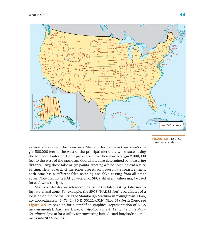
FIGURE 2.8 The SPCS
zones for all states.
MT
NE
TX-C
NC
TN
TX-NC
SC
OR-S
AZ-C
TX-SC
NV-E
KS-S
ID-W
UT-C
CA-5
SD-N
NM-E
NM-C
CO-S
OR-N
IA-N
SD-S
OK-N
ND-N
ND-S
KS-N
NV-W
IL-E
CA-1
WA-S
IL-W
CO-C
VA-S
MN-N
CO-N
MI-S
OK-S
KY-S
UT-S
AL-W
IA-S
CA-4
WA-N
MN-S
ID-C
AR-N
FL-E
TX-N
NY-E
AR-S
LA-S
WI-C
GA-E
PA-S
PA-N
MN-C
IN-E
CA-2
LA-N
WI-S
OH-N
MO-E
ID-E
VT
CA-3
TX-S
OH-S
CA-6
NH
MI-C
WV-S
NY-C
GA-W
MO-C
WY-E
M S- E
NV-C
AZ -W
A L- E
FL-N
WY- WC
M S- W
ME-E
WY-E C
IN-W
MI-N
MD
NJ
MO-W
WI-N
UT-N
WY -W
FL-W
ME-W
KY-N
CT
VA-N
WV-N
MA-M
NY-W
DE
RI
NY-LI
MA-I
AZ-E
NM-W
SPC Zones
AK-1
HI-4
HI-5
HI-3
HI-2
HI-1
AK
-2
AK-3
AK-4
AK-5
AK-6
AK-7
AK-10
AK-8
AK-9
What Is SPCS?
version, states using the Transverse Mercator format have their zone’s origin 500,000 feet to the west of the principal meridian, while states using
the Lambert Conformal Conic projection have their zone’s origin 2,000,000
feet to the west of the meridian. Coordinates are determined by measuring
distance using these false origin points, creating a false northing and a false
easting. Thus, as each of the zones uses its own coordinate measurements,
each zone has a different false northing and false easting from all other
zones. Note that in the NAD83 version of SPCS, different values may be used
for each zone’s origin.
SPCS coordinates are referenced by listing the false easting, false northing, state, and zone. For example, the SPCS (NAD83 feet) coordinates of a
location on the football field of Stambaugh Stadium in Youngstown, Ohio,
are approximately: 2478424.96 E, 531216.31N, Ohio, N (North Zone; see
Figure 2.9 on page 44 for a simplified graphical representation of SPCS
measurements). Also, see Hands-on Application 2.4: Using the State Plane
Coordinate System for a utility for converting latitude and longitude coordinates into SPCS values.
FIGURE 2.8 The SPCS
zones for all states.
MT
NE
TX-C
NC
TN
TX-NC
SC
OR-S
AZ-C
TX-SC
NV-E
KS-S
ID-W
UT-C
CA-5
SD-N
NM-E
NM-C
CO-S
OR-N
IA-N
SD-S
OK-N
ND-N
ND-S
KS-N
NV-W
IL-E
CA-1
WA-S
IL-W
CO-C
VA-S
MN-N
CO-N
MI-S
OK-S
KY-S
UT-S
AL-W
IA-S
CA-4
WA-N
MN-S
ID-C
AR-N
FL-E
TX-N
NY-E
AR-S
LA-S
WI-C
GA-E
PA-S
PA-N
MN-C
IN-E
CA-2
LA-N
WI-S
OH-N
MO-E
ID-E
VT
CA-3
TX-S
OH-S
CA-6
NH
MI-C
WV-S
NY-C
GA-W
MO-C
WY-E
M S- E
NV-C
AZ -W
A L- E
FL-N
WY- WC
M S- W
ME-E
WY-E C
IN-W
MI-N
MD
NJ
MO-W
WI-N
UT-N
WY -W
FL-W
ME-W
KY-N
CT
VA-N
WV-N
MA-M
NY-W
DE
RI
NY-LI
MA-I
AZ-E
NM-W
SPC Zones
AK-1
HI-4
HI-5
HI-3
HI-2
HI-1
AK
-2
AK-3
AK-4
AK-5
AK-6
AK-7
AK-10
AK-8
AK-9