

41
What Is SPCS?
of Buffalo, Wyoming, is also in Zone 13, and has an easting value of 365,568
m. This indicates this location is approximately 134,432 m to the west of Zone
13’s central meridian—(500,000 – 134,432). No zone is more than 1,000,000
meters wide, so no negative values will be assigned to eastings in a zone. This
value for easting is referred to as a false easting since the easting calculation
is based on a central meridian for each zone.
When UTM coordinates are written, the false easting, northing, and zone
must all be specified. If a false northing is used (that is, the coordinates are
found in a location south of the Equator), then a notation that the coordinates
are from the southern hemisphere is included. For example, the UTM
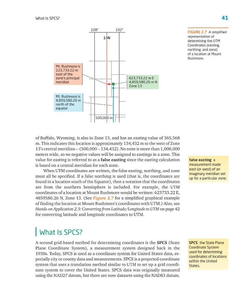
coordinates of a location at Mount Rushmore would be written: 623733.22 E,
4859580.26 N, Zone 13. (See Figure 2.7 for a simplified graphical example
of finding the location at Mount Rushmore’s coordinates with UTM.) Also, see
Hands-on Application 2.3: Converting from Latitude/Longitude to UTM on page 42
for converting latitude and longitude coordinates to UTM.
What Is SPCS?
A second grid-based method for determining coordinates is the SPCS (State
Plane Coordinate System), a measurement system designed back in the
1930s. Today, SPCS is used as a coordinate system for United States data, especially city or county data and measurements. SPCS is a projected coordinate
system that uses a translation method similar to UTM to set up a grid coordinate system to cover the United States. SPCS data was originally measured
using the NAD27 datum, but there are now datasets using the NAD83 datum.
false easting a
measurement made
east (or west) of an
imaginary meridian set
up for a particular zone.
FIGURE 2.7 A simplified
representation of
determining the UTM
Coordinates (easting,
northing, and zone)
of a location at Mount
Rushmore.
SPCS the State Plane
Coordinate System
used for determining
coordinates of locations
within the United
States.
500,000 m
500,000 m
500,000 m
Mt. Rushmore is
123,733.22 m
east of the
zone’s principal
meridian
13N
13N
108°
102°
13N
Mt. Rushmore is
4,859,580.26 m
north of the
equator
623,733.22 m E
4,859,580.26 m N
Zone 13
What Is SPCS?
of Buffalo, Wyoming, is also in Zone 13, and has an easting value of 365,568
m. This indicates this location is approximately 134,432 m to the west of Zone
13’s central meridian—(500,000 – 134,432). No zone is more than 1,000,000
meters wide, so no negative values will be assigned to eastings in a zone. This
value for easting is referred to as a false easting since the easting calculation
is based on a central meridian for each zone.
When UTM coordinates are written, the false easting, northing, and zone
must all be specified. If a false northing is used (that is, the coordinates are
found in a location south of the Equator), then a notation that the coordinates
are from the southern hemisphere is included. For example, the UTM
coordinates of a location at Mount Rushmore would be written: 623733.22 E,
4859580.26 N, Zone 13. (See Figure 2.7 for a simplified graphical example
of finding the location at Mount Rushmore’s coordinates with UTM.) Also, see
Hands-on Application 2.3: Converting from Latitude/Longitude to UTM on page 42
for converting latitude and longitude coordinates to UTM.
What Is SPCS?
A second grid-based method for determining coordinates is the SPCS (State
Plane Coordinate System), a measurement system designed back in the
1930s. Today, SPCS is used as a coordinate system for United States data, especially city or county data and measurements. SPCS is a projected coordinate
system that uses a translation method similar to UTM to set up a grid coordinate system to cover the United States. SPCS data was originally measured
using the NAD27 datum, but there are now datasets using the NAD83 datum.
false easting a
measurement made
east (or west) of an
imaginary meridian set
up for a particular zone.
FIGURE 2.7 A simplified
representation of
determining the UTM
Coordinates (easting,
northing, and zone)
of a location at Mount
Rushmore.
SPCS the State Plane
Coordinate System
used for determining
coordinates of locations
within the United
States.
500,000 m
500,000 m
500,000 m
Mt. Rushmore is
123,733.22 m
east of the
zone’s principal
meridian
13N
13N
108°
102°
13N
Mt. Rushmore is
4,859,580.26 m
north of the
equator
623,733.22 m E
4,859,580.26 m N
Zone 13