

40
Chapter 2 Where in the Geospatial World Are You?
meters as its measurement unit. UTM’s x and y coordinates are referred to
as an easting and a northing. The UTM northing is found by counting the
number of meters the point is north of the Equator. For instance, a particular
location at Mount Rushmore is located 4,859,580 meters to the north of the
Equator.
Locations in the southern hemisphere handle northing a little differently since UTM does not contain negative values. For southern hemisphere
locations, count the number of meters south of the Equator to the point (as a
negative value), then add 10,000,000 m to the number. For example, a location at the Opera House in Sydney, Australia (in the southern hemisphere),
has a northing of 6,252,268 m. This indicates it would be approximately
3,747,732 meters south of the Equator (−3,747,732 + 10,000,000). Another
way of conceptualizing this is to assume that (for southern hemisphere locations) rather than measuring north of the Equator, you’re measuring north
of an imaginary line drawn 10,000,000 meters south of the Equator. This
extra 10 million meters is referred to as a false northing since it’s a value
set up by the system’s designers to avoid negative values.
The next step is to measure the point’s easting. Unlike GCS, there is no
one Prime Meridian to make measurements from. Instead, each UTM Zone
has its own central meridian which runs through the zone’s center. This central meridian is given a value of 500,000 m, and measurements are made to
the east (adding meters) or west (subtracting meters) from this value. For
example, our specific spot at Mount Rushmore is located 123,733.22 m to the
east of Zone 13’s central meridian—so the easting for this location at Mount
Rushmore is 623,733.22 m (500,000 + 123,733.22). A location in the town
easting a
measurement of so
many units east (or
west) of some principal
meridian.
northing a
measurement of so
many units north (or
south) of a baseline.
false northing a
measurement made
north (or south) of an
imaginary line such
as used in measuring
UTM northings in the
southern hemisphere.
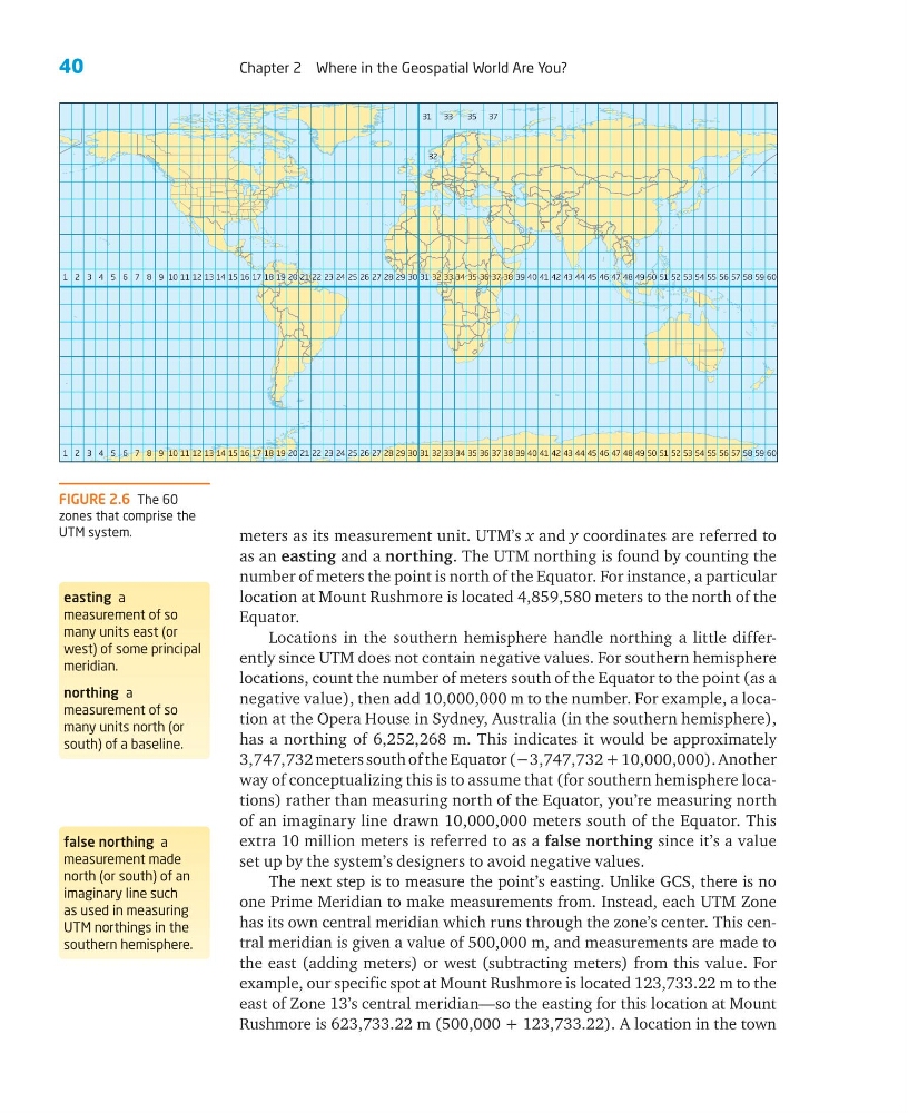
FIGURE 2.6 The 60
zones that comprise the
UTM system.
1234567891 0 1 1 1 2 1 3 1 4 1 5 1 6 1 7 1 8 1 9 2 0 2 1 2 2 2 3 2 4 2 5 2 6 2 7 2 8 2 9
3 1
31 33
35 37
30
32
32
33 34 35 36 37 38 39 40 41 42 43 44 45 46 47 48 49 50 51 52 53 54 55 56 57 58 59 60
1234567891 0 1 1 1 2 1 3 1 4 1 5 1 6 1 7 1 8 1 9 2 0 2 1 2 2 2 3 2 4 2 5 2 6 2 7 2 8 2 9
3 1
30
32 33 34 35 36 37 38 39 40 41 42 43 44 45 46 47 48 49 50 51 52 53 54 55 56 57 58 59 60
Chapter 2 Where in the Geospatial World Are You?
meters as its measurement unit. UTM’s x and y coordinates are referred to
as an easting and a northing. The UTM northing is found by counting the
number of meters the point is north of the Equator. For instance, a particular
location at Mount Rushmore is located 4,859,580 meters to the north of the
Equator.
Locations in the southern hemisphere handle northing a little differently since UTM does not contain negative values. For southern hemisphere
locations, count the number of meters south of the Equator to the point (as a
negative value), then add 10,000,000 m to the number. For example, a location at the Opera House in Sydney, Australia (in the southern hemisphere),
has a northing of 6,252,268 m. This indicates it would be approximately
3,747,732 meters south of the Equator (−3,747,732 + 10,000,000). Another
way of conceptualizing this is to assume that (for southern hemisphere locations) rather than measuring north of the Equator, you’re measuring north
of an imaginary line drawn 10,000,000 meters south of the Equator. This
extra 10 million meters is referred to as a false northing since it’s a value
set up by the system’s designers to avoid negative values.
The next step is to measure the point’s easting. Unlike GCS, there is no
one Prime Meridian to make measurements from. Instead, each UTM Zone
has its own central meridian which runs through the zone’s center. This central meridian is given a value of 500,000 m, and measurements are made to
the east (adding meters) or west (subtracting meters) from this value. For
example, our specific spot at Mount Rushmore is located 123,733.22 m to the
east of Zone 13’s central meridian—so the easting for this location at Mount
Rushmore is 623,733.22 m (500,000 + 123,733.22). A location in the town
easting a
measurement of so
many units east (or
west) of some principal
meridian.
northing a
measurement of so
many units north (or
south) of a baseline.
false northing a
measurement made
north (or south) of an
imaginary line such
as used in measuring
UTM northings in the
southern hemisphere.
FIGURE 2.6 The 60
zones that comprise the
UTM system.
1234567891 0 1 1 1 2 1 3 1 4 1 5 1 6 1 7 1 8 1 9 2 0 2 1 2 2 2 3 2 4 2 5 2 6 2 7 2 8 2 9
3 1
31 33
35 37
30
32
32
33 34 35 36 37 38 39 40 41 42 43 44 45 46 47 48 49 50 51 52 53 54 55 56 57 58 59 60
1234567891 0 1 1 1 2 1 3 1 4 1 5 1 6 1 7 1 8 1 9 2 0 2 1 2 2 2 3 2 4 2 5 2 6 2 7 2 8 2 9
3 1
30
32 33 34 35 36 37 38 39 40 41 42 43 44 45 46 47 48 49 50 51 52 53 54 55 56 57 58 59 60