

462
Chapter 15 What’s Next for Geospatial Technology?
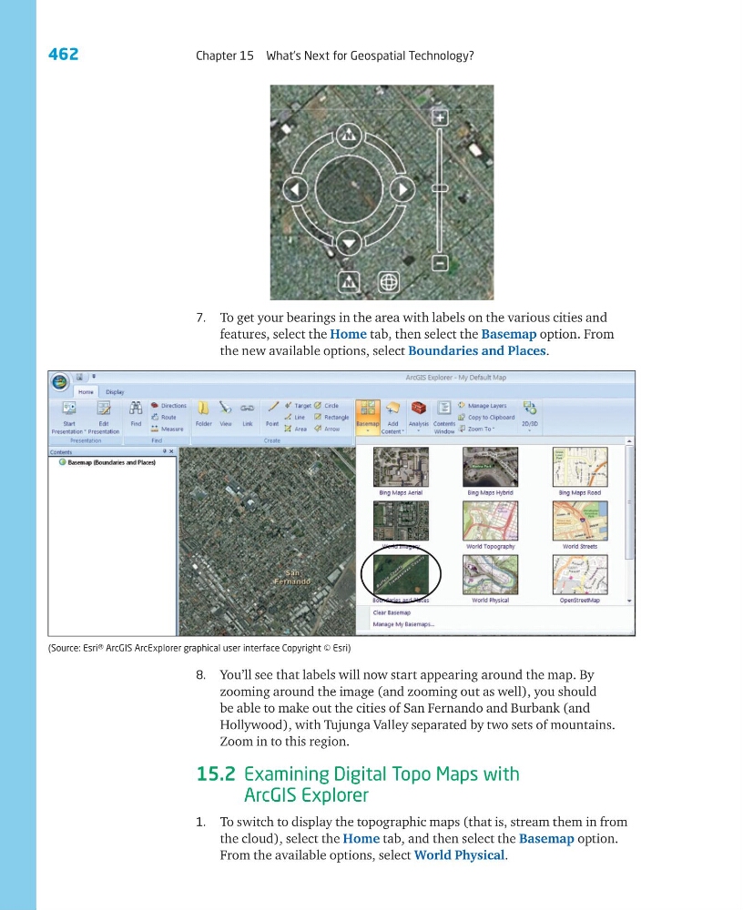
7. To get your bearings in the area with labels on the various cities and
features, select the Home tab, then select the Basemap option. From
the new available options, select Boundaries and Places.
8. You’ll see that labels will now start appearing around the map. By
zooming around the image (and zooming out as well), you should
be able to make out the cities of San Fernando and Burbank (and
Hollywood), with Tujunga Valley separated by two sets of mountains.
Zoom in to this region.
15.2 Examining Digital Topo Maps with
ArcGIS Explorer
1. To switch to display the topographic maps (that is, stream them in from
the cloud), select the Home tab, and then select the Basemap option.
From the available options, select World Physical.
(Source: Esri® ArcGIS ArcExplorer graphical user interface Copyright © Esri)
Chapter 15 What’s Next for Geospatial Technology?
7. To get your bearings in the area with labels on the various cities and
features, select the Home tab, then select the Basemap option. From
the new available options, select Boundaries and Places.
8. You’ll see that labels will now start appearing around the map. By
zooming around the image (and zooming out as well), you should
be able to make out the cities of San Fernando and Burbank (and
Hollywood), with Tujunga Valley separated by two sets of mountains.
Zoom in to this region.
15.2 Examining Digital Topo Maps with
ArcGIS Explorer
1. To switch to display the topographic maps (that is, stream them in from
the cloud), select the Home tab, and then select the Basemap option.
From the available options, select World Physical.
(Source: Esri® ArcGIS ArcExplorer graphical user interface Copyright © Esri)