

386
Chapter 13 Digital Landscaping
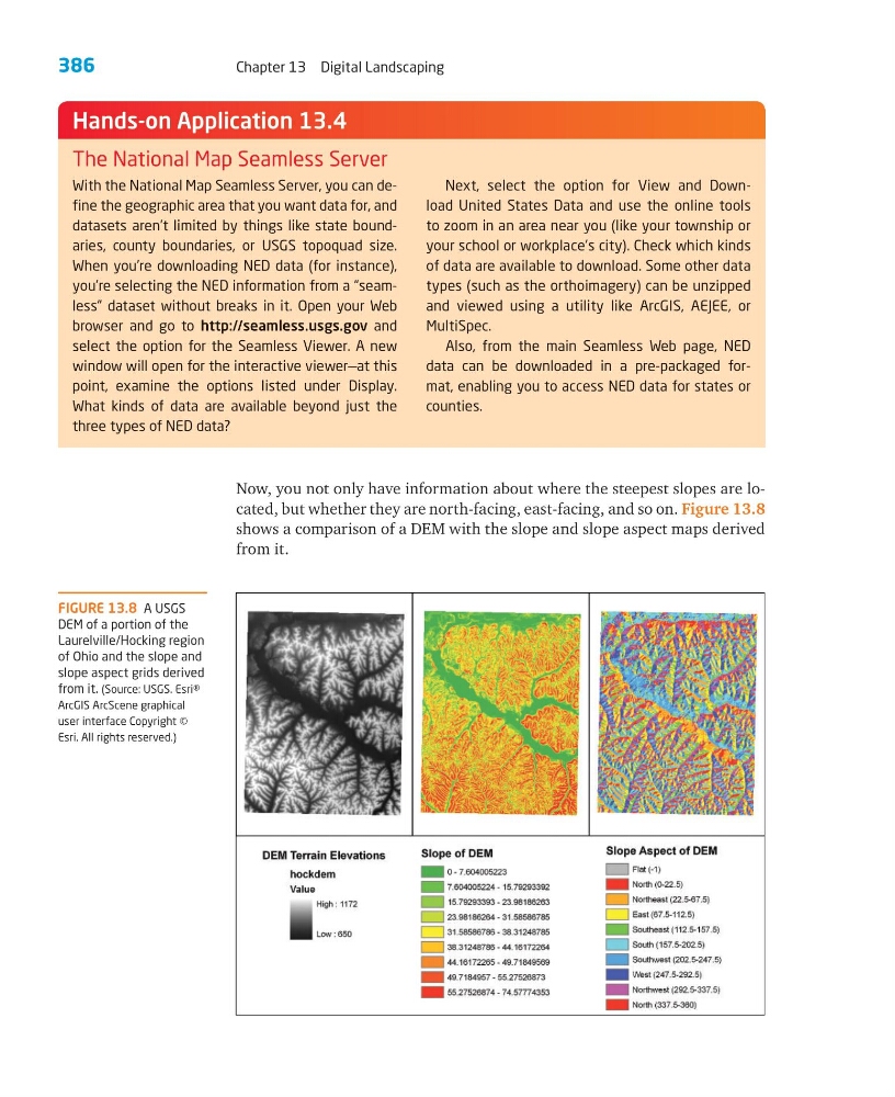
Now, you not only have information about where the steepest slopes are located, but whether they are north-facing, east-facing, and so on. Figure 13.8
shows a comparison of a DEM with the slope and slope aspect maps derived
from it.
With the National Map Seamless Server, you can define the geographic area that you want data for, and
datasets aren’t limited by things like state boundaries, county boundaries, or USGS topoquad size.
When you’re downloading NED data (for instance),
you’re selecting the NED information from a “seamless” dataset without breaks in it. Open your Web
browser and go to http://seamless.usgs.gov and
select the option for the Seamless Viewer. A new
window will open for the interactive viewer—at this
point, examine the options listed under Display.
What kinds of data are available beyond just the
three types of NED data?
Next, select the option for View and Download United States Data and use the online tools
to zoom in an area near you (like your township or
your school or workplace’s city). Check which kinds
of data are available to download. Some other data
types (such as the orthoimagery) can be unzipped
and viewed using a utility like ArcGIS, AEJEE, or
MultiSpec.
Also, from the main Seamless Web page, NED
data can be downloaded in a pre-packaged format, enabling you to access NED data for states or
counties.
Hands-on Application 13.4
The National Map Seamless Server
FIGURE 13.8 A USGS
DEM of a portion of the
Laurelville/Hocking region
of Ohio and the slope and
slope aspect grids derived
from it. (Source: USGS. Esri®
ArcGIS ArcScene graphical
user interface Copyright ©
Esri. All rights reserved.)
Chapter 13 Digital Landscaping
Now, you not only have information about where the steepest slopes are located, but whether they are north-facing, east-facing, and so on. Figure 13.8
shows a comparison of a DEM with the slope and slope aspect maps derived
from it.
With the National Map Seamless Server, you can define the geographic area that you want data for, and
datasets aren’t limited by things like state boundaries, county boundaries, or USGS topoquad size.
When you’re downloading NED data (for instance),
you’re selecting the NED information from a “seamless” dataset without breaks in it. Open your Web
browser and go to http://seamless.usgs.gov and
select the option for the Seamless Viewer. A new
window will open for the interactive viewer—at this
point, examine the options listed under Display.
What kinds of data are available beyond just the
three types of NED data?
Next, select the option for View and Download United States Data and use the online tools
to zoom in an area near you (like your township or
your school or workplace’s city). Check which kinds
of data are available to download. Some other data
types (such as the orthoimagery) can be unzipped
and viewed using a utility like ArcGIS, AEJEE, or
MultiSpec.
Also, from the main Seamless Web page, NED
data can be downloaded in a pre-packaged format, enabling you to access NED data for states or
counties.
Hands-on Application 13.4
The National Map Seamless Server
FIGURE 13.8 A USGS
DEM of a portion of the
Laurelville/Hocking region
of Ohio and the slope and
slope aspect grids derived
from it. (Source: USGS. Esri®
ArcGIS ArcScene graphical
user interface Copyright ©
Esri. All rights reserved.)