

335
What Is a Landsat Satellite and What Does It Do?
OhioView and AmericaView (see Chapter 15) a lot of Landsat imagery is freely
available for distribution over the Internet. The USGS maintains an online
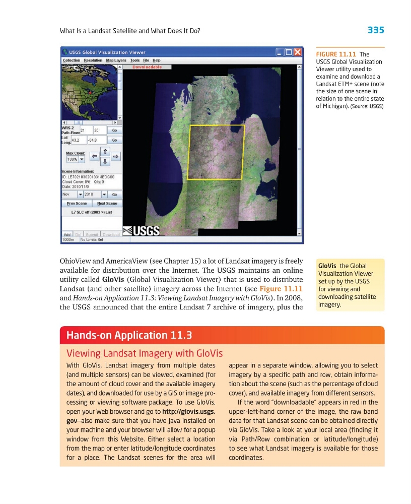
utility called GloVis (Global Visualization Viewer) that is used to distribute
Landsat (and other satellite) imagery across the Internet (see Figure 11.11
and Hands-on Application 11.3: Viewing Landsat Imagery with GloVis). In 2008,
the USGS announced that the entire Landsat 7 archive of imagery, plus the
GloVis the Global
Visualization Viewer
set up by the USGS
for viewing and
downloading satellite
imagery.
FIGURE 11.11 The
USGS Global Visualization
Viewer utility used to
examine and download a
Landsat ETM+ scene (note
the size of one scene in
relation to the entire state
of Michigan). (Source: USGS)
With GloVis, Landsat imagery from multiple dates
(and multiple sensors) can be viewed, examined (for
the amount of cloud cover and the available imagery
dates), and downloaded for use by a GIS or image processing or viewing software package. To use GloVis,
open your Web browser and go to http:// glovis.usgs.
gov—also make sure that you have Java installed on
your machine and your browser will allow for a popup
window from this Website. Either select a location
from the map or enter latitude/longitude coordinates
for a place. The Landsat scenes for the area will
appear in a separate window, allowing you to select
imagery by a specific path and row, obtain information about the scene (such as the percentage of cloud
cover), and available imagery from different sensors.
If the word “downloadable” appears in red in the
upper-left-hand corner of the image, the raw band
data for that Landsat scene can be obtained directly
via GloVis. Take a look at your local area (finding it
via Path/Row combination or latitude/longitude)
to see what Landsat imagery is available for those
coordinates.
Hands-on Application 11.3
Viewing Landsat Imagery with GloVis
What Is a Landsat Satellite and What Does It Do?
OhioView and AmericaView (see Chapter 15) a lot of Landsat imagery is freely
available for distribution over the Internet. The USGS maintains an online
utility called GloVis (Global Visualization Viewer) that is used to distribute
Landsat (and other satellite) imagery across the Internet (see Figure 11.11
and Hands-on Application 11.3: Viewing Landsat Imagery with GloVis). In 2008,
the USGS announced that the entire Landsat 7 archive of imagery, plus the
GloVis the Global
Visualization Viewer
set up by the USGS
for viewing and
downloading satellite
imagery.
FIGURE 11.11 The
USGS Global Visualization
Viewer utility used to
examine and download a
Landsat ETM+ scene (note
the size of one scene in
relation to the entire state
of Michigan). (Source: USGS)
With GloVis, Landsat imagery from multiple dates
(and multiple sensors) can be viewed, examined (for
the amount of cloud cover and the available imagery
dates), and downloaded for use by a GIS or image processing or viewing software package. To use GloVis,
open your Web browser and go to http:// glovis.usgs.
gov—also make sure that you have Java installed on
your machine and your browser will allow for a popup
window from this Website. Either select a location
from the map or enter latitude/longitude coordinates
for a place. The Landsat scenes for the area will
appear in a separate window, allowing you to select
imagery by a specific path and row, obtain information about the scene (such as the percentage of cloud
cover), and available imagery from different sensors.
If the word “downloadable” appears in red in the
upper-left-hand corner of the image, the raw band
data for that Landsat scene can be obtained directly
via GloVis. Take a look at your local area (finding it
via Path/Row combination or latitude/longitude)
to see what Landsat imagery is available for those
coordinates.
Hands-on Application 11.3
Viewing Landsat Imagery with GloVis