

334
Chapter 11 Images from Space
For a dynamic look at streaming Landsat imagery,
the EarthNow! Website (sponsored by the USGS and
available online at http://earthnow.usgs.gov) is a
great tool (use of EarthNow! requires you to have
Java loaded on your computer). EarthNow! shows recent Landsat imagery (usually from today’s date)—a
small map on the screen will show the position and
orbit of the Landsat satellite that acquired the imagery. The main EarthNow! window will show the
imagery collected by Landsat (with attached labels
added by those who processed the data). Check out
EarthNow! to see where recent Landsat imagery
was collected and what the images of the ground
that are obtained by Landsat look like.
Hands-on Application 11.2
Streaming Landsat Imagery
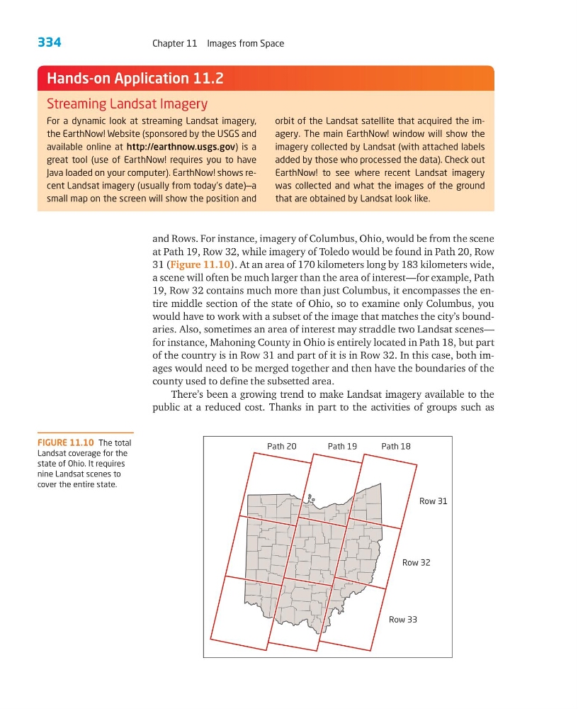
and Rows. For instance, imagery of Columbus, Ohio, would be from the scene
at Path 19, Row 32, while imagery of Toledo would be found in Path 20, Row
31 (Figure 11.10). At an area of 170 kilometers long by 183 kilometers wide,
a scene will often be much larger than the area of interest—for example, Path
19, Row 32 contains much more than just Columbus, it encompasses the entire middle section of the state of Ohio, so to examine only Columbus, you
would have to work with a subset of the image that matches the city’s boundaries. Also, sometimes an area of interest may straddle two Landsat scenes—
for instance, Mahoning County in Ohio is entirely located in Path 18, but part
of the country is in Row 31 and part of it is in Row 32. In this case, both images would need to be merged together and then have the boundaries of the
county used to define the subsetted area.
There’s been a growing trend to make Landsat imagery available to the
public at a reduced cost. Thanks in part to the activities of groups such as
FIGURE 11.10 The total
Landsat coverage for the
state of Ohio. It requires
nine Landsat scenes to
cover the entire state.
Path 20
Path 19
Path 18
Row 31
Row 32
Row 33
Chapter 11 Images from Space
For a dynamic look at streaming Landsat imagery,
the EarthNow! Website (sponsored by the USGS and
available online at http://earthnow.usgs.gov) is a
great tool (use of EarthNow! requires you to have
Java loaded on your computer). EarthNow! shows recent Landsat imagery (usually from today’s date)—a
small map on the screen will show the position and
orbit of the Landsat satellite that acquired the imagery. The main EarthNow! window will show the
imagery collected by Landsat (with attached labels
added by those who processed the data). Check out
EarthNow! to see where recent Landsat imagery
was collected and what the images of the ground
that are obtained by Landsat look like.
Hands-on Application 11.2
Streaming Landsat Imagery
and Rows. For instance, imagery of Columbus, Ohio, would be from the scene
at Path 19, Row 32, while imagery of Toledo would be found in Path 20, Row
31 (Figure 11.10). At an area of 170 kilometers long by 183 kilometers wide,
a scene will often be much larger than the area of interest—for example, Path
19, Row 32 contains much more than just Columbus, it encompasses the entire middle section of the state of Ohio, so to examine only Columbus, you
would have to work with a subset of the image that matches the city’s boundaries. Also, sometimes an area of interest may straddle two Landsat scenes—
for instance, Mahoning County in Ohio is entirely located in Path 18, but part
of the country is in Row 31 and part of it is in Row 32. In this case, both images would need to be merged together and then have the boundaries of the
county used to define the subsetted area.
There’s been a growing trend to make Landsat imagery available to the
public at a reduced cost. Thanks in part to the activities of groups such as
FIGURE 11.10 The total
Landsat coverage for the
state of Ohio. It requires
nine Landsat scenes to
cover the entire state.
Path 20
Path 19
Path 18
Row 31
Row 32
Row 33