

331
What Is a Landsat Satellite and What Does It Do?
rapid responses (such as mitigating disasters resulting from hurricanes, tornadoes, or widespread fires).
The sensor’s last parameter is spectral resolution, which refers to the
bands and their wavelengths measured by the sensor. For instance, a sensor
on the QuickBird satellite can measure four bands of energy simultaneously
(wavelengths in the blue, green, red, and near-infrared portions of the spectrum), and the sensor onboard the Landsat 7 satellite can sense in seven different wavelengths at the same time. A sensor with a higher spectral resolution
could examine several finer intervals of energy wavelengths (for example, the
MODIS sensor onboard the Terra satellite—see Chapter 12—can sense in 36
different bands at once). Being able to sense numerous smaller wavelengths
in the near-infrared portion of the spectrum gives much finer spectral resolution than just sensing one wider wavelength of near-infrared energy.
What Is a Landsat Satellite
and What Does It Do?
This chapter and Chapter 10 have made mention of a satellite system called
Landsat but haven’t really explained what it is, how it operates, or why it’s
so important. What would become the United States’ Landsat Program was
conceived in the late 1960s as a resource for doing remote sensing of Earth
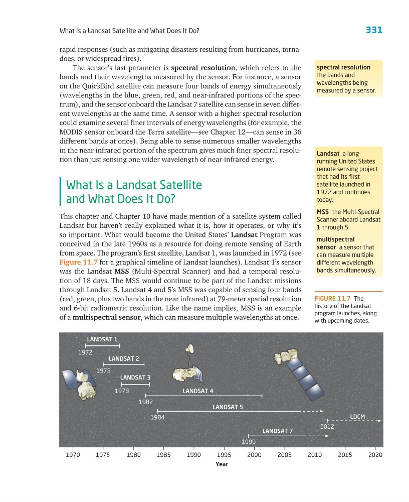
from space. The program’s first satellite, Landsat 1, was launched in 1972 (see
Figure 11.7 for a graphical timeline of Landsat launches). Landsat 1’s sensor
was the Landsat MSS (Multi-Spectral Scanner) and had a temporal resolution of 18 days. The MSS would continue to be part of the Landsat missions
through Landsat 5. Landsat 4 and 5’s MSS was capable of sensing four bands
(red, green, plus two bands in the near infrared) at 79-meter spatial resolution
and 6-bit radiometric resolution. Like the name implies, MSS is an example
of a multispectral sensor, which can measure multiple wavelengths at once.
spectral resolution
the bands and
wavelengths being
measured by a sensor.
Landsat a longrunning United States
remote sensing project
that had its first
satellite launched in
1972 and continues
today.
MSS the Multi-Spectral
Scanner aboard Landsat
1 through 5.
multispectral
sensor a sensor that
can measure multiple
different wavelength
bands simultaneously.
1970
1975
2020
1980
1985
1990
Year
1995
2000
2005
2010
2015
LANDSAT 1
LANDSAT 2
LANDSAT 3
LANDSAT 4
LANDSAT 5
LANDSAT 7
LDCM
1972
1975
1978
1982
1984
1999
2012
FIGURE 11.7 The
history of the Landsat
program launches, along
with upcoming dates.
What Is a Landsat Satellite and What Does It Do?
rapid responses (such as mitigating disasters resulting from hurricanes, tornadoes, or widespread fires).
The sensor’s last parameter is spectral resolution, which refers to the
bands and their wavelengths measured by the sensor. For instance, a sensor
on the QuickBird satellite can measure four bands of energy simultaneously
(wavelengths in the blue, green, red, and near-infrared portions of the spectrum), and the sensor onboard the Landsat 7 satellite can sense in seven different wavelengths at the same time. A sensor with a higher spectral resolution
could examine several finer intervals of energy wavelengths (for example, the
MODIS sensor onboard the Terra satellite—see Chapter 12—can sense in 36
different bands at once). Being able to sense numerous smaller wavelengths
in the near-infrared portion of the spectrum gives much finer spectral resolution than just sensing one wider wavelength of near-infrared energy.
What Is a Landsat Satellite
and What Does It Do?
This chapter and Chapter 10 have made mention of a satellite system called
Landsat but haven’t really explained what it is, how it operates, or why it’s
so important. What would become the United States’ Landsat Program was
conceived in the late 1960s as a resource for doing remote sensing of Earth
from space. The program’s first satellite, Landsat 1, was launched in 1972 (see
Figure 11.7 for a graphical timeline of Landsat launches). Landsat 1’s sensor
was the Landsat MSS (Multi-Spectral Scanner) and had a temporal resolution of 18 days. The MSS would continue to be part of the Landsat missions
through Landsat 5. Landsat 4 and 5’s MSS was capable of sensing four bands
(red, green, plus two bands in the near infrared) at 79-meter spatial resolution
and 6-bit radiometric resolution. Like the name implies, MSS is an example
of a multispectral sensor, which can measure multiple wavelengths at once.
spectral resolution
the bands and
wavelengths being
measured by a sensor.
Landsat a longrunning United States
remote sensing project
that had its first
satellite launched in
1972 and continues
today.
MSS the Multi-Spectral
Scanner aboard Landsat
1 through 5.
multispectral
sensor a sensor that
can measure multiple
different wavelength
bands simultaneously.
1970
1975
2020
1980
1985
1990
Year
1995
2000
2005
2010
2015
LANDSAT 1
LANDSAT 2
LANDSAT 3
LANDSAT 4
LANDSAT 5
LANDSAT 7
LDCM
1972
1975
1978
1982
1984
1999
2012
FIGURE 11.7 The
history of the Landsat
program launches, along
with upcoming dates.