

325
How Do Remote Sensing Satellites Collect Data?
no need to wait for a plane to fly over an area. Satellites can also image a much
larger area than a single aerial photograph can. Also, remote sensing satellites provide global coverage and are not restricted to geographic boundaries
or constraints the way aircraft are because satellites orbit hundreds of miles
above Earth’s surface.
How Do Remote Sensing Satellites
Collect Data?
Remote sensing satellites are placed in a specific orbital path around Earth.
One type of orbit used in remote sensing is geostationary orbit, in which satellites rotate at the same speed as Earth. Since a geostationary satellite takes
24 hours to make one orbit, it’s always in the same place at the same time. For
instance, although it’s not a remote sensing system, satellite television utilizes
a geostationary orbit—the satellite handling the broadcasting is in orbit over
the same area continuously, which is why a satellite reception dish needs to
always be pointed at the same part of the sky. Likewise, the WAAS and EGNOS
satellites discussed in Chapter 4 are also in geostationary orbit, so they can
provide constant coverage to the same area on Earth. There are some remote
sensing satellites that use geostationary orbit to always collect information
about the same area on Earth’s surface (such as the GOES series of satellites
used for obtaining weather imagery).
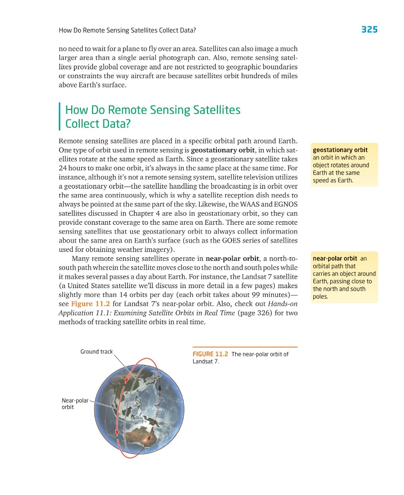
Many remote sensing satellites operate in near-polar orbit, a north-tosouth path wherein the satellite moves close to the north and south poles while
it makes several passes a day about Earth. For instance, the Landsat 7 satellite
(a United States satellite we’ll discuss in more detail in a few pages) makes
slightly more than 14 orbits per day (each orbit takes about 99 minutes)—
see Figure 11.2 for Landsat 7’s near-polar orbit. Also, check out Hands-on
Application 11.1: Examining Satellite Orbits in Real Time (page 326) for two
methods of tracking satellite orbits in real time.
geostationary orbit
an orbit in which an
object rotates around
Earth at the same
speed as Earth.
near-polar orbit an
orbital path that
carries an object around
Earth, passing close to
the north and south
poles.
FIGURE 11.2 The near-polar orbit of
Landsat 7.
Near-polar
orbit
Ground track
How Do Remote Sensing Satellites Collect Data?
no need to wait for a plane to fly over an area. Satellites can also image a much
larger area than a single aerial photograph can. Also, remote sensing satellites provide global coverage and are not restricted to geographic boundaries
or constraints the way aircraft are because satellites orbit hundreds of miles
above Earth’s surface.
How Do Remote Sensing Satellites
Collect Data?
Remote sensing satellites are placed in a specific orbital path around Earth.
One type of orbit used in remote sensing is geostationary orbit, in which satellites rotate at the same speed as Earth. Since a geostationary satellite takes
24 hours to make one orbit, it’s always in the same place at the same time. For
instance, although it’s not a remote sensing system, satellite television utilizes
a geostationary orbit—the satellite handling the broadcasting is in orbit over
the same area continuously, which is why a satellite reception dish needs to
always be pointed at the same part of the sky. Likewise, the WAAS and EGNOS
satellites discussed in Chapter 4 are also in geostationary orbit, so they can
provide constant coverage to the same area on Earth. There are some remote
sensing satellites that use geostationary orbit to always collect information
about the same area on Earth’s surface (such as the GOES series of satellites
used for obtaining weather imagery).
Many remote sensing satellites operate in near-polar orbit, a north-tosouth path wherein the satellite moves close to the north and south poles while
it makes several passes a day about Earth. For instance, the Landsat 7 satellite
(a United States satellite we’ll discuss in more detail in a few pages) makes
slightly more than 14 orbits per day (each orbit takes about 99 minutes)—
see Figure 11.2 for Landsat 7’s near-polar orbit. Also, check out Hands-on
Application 11.1: Examining Satellite Orbits in Real Time (page 326) for two
methods of tracking satellite orbits in real time.
geostationary orbit
an orbit in which an
object rotates around
Earth at the same
speed as Earth.
near-polar orbit an
orbital path that
carries an object around
Earth, passing close to
the north and south
poles.
FIGURE 11.2 The near-polar orbit of
Landsat 7.
Near-polar
orbit
Ground track