

324
Chapter 11 Images from Space
States space and aeronautics program. Satellites were used for remote sensing reconnaissance and surveillance beginning with the Corona program
in 1960.
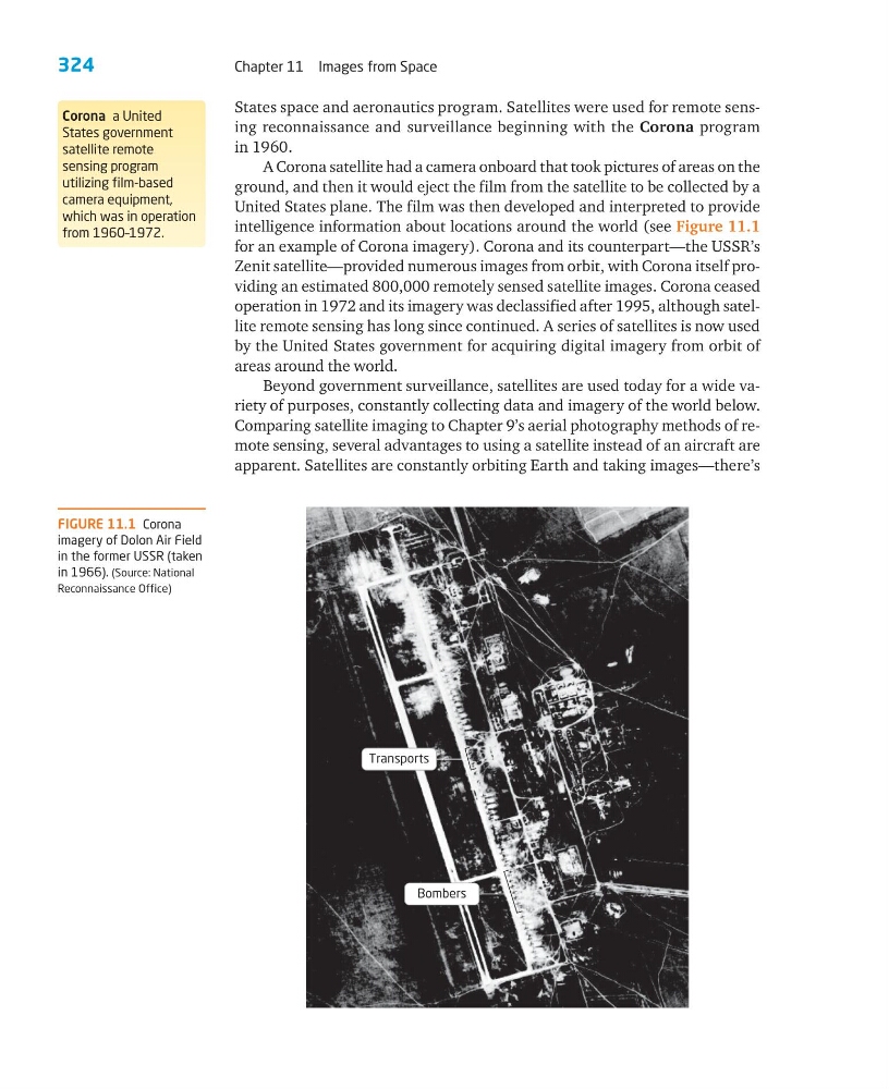
A Corona satellite had a camera onboard that took pictures of areas on the
ground, and then it would eject the film from the satellite to be collected by a
United States plane. The film was then developed and interpreted to provide
intelligence information about locations around the world (see Figure 11.1
for an example of Corona imagery). Corona and its counterpart—the USSR’s
Zenit satellite—provided numerous images from orbit, with Corona itself providing an estimated 800,000 remotely sensed satellite images. Corona ceased
operation in 1972 and its imagery was declassified after 1995, although satellite remote sensing has long since continued. A series of satellites is now used
by the United States government for acquiring digital imagery from orbit of
areas around the world.
Beyond government surveillance, satellites are used today for a wide variety of purposes, constantly collecting data and imagery of the world below.
Comparing satellite imaging to Chapter 9’s aerial photography methods of remote sensing, several advantages to using a satellite instead of an aircraft are
apparent. Satellites are constantly orbiting Earth and taking images—there’s
Corona a United
States government
satellite remote
sensing program
utilizing film-based
camera equipment,
which was in operation
from 1960–1972.
FIGURE 11.1 Corona
imagery of Dolon Air Field
in the former USSR (taken
in 1966). (Source: National
Reconnaissance Office)
Transports
Bombers
Chapter 11 Images from Space
States space and aeronautics program. Satellites were used for remote sensing reconnaissance and surveillance beginning with the Corona program
in 1960.
A Corona satellite had a camera onboard that took pictures of areas on the
ground, and then it would eject the film from the satellite to be collected by a
United States plane. The film was then developed and interpreted to provide
intelligence information about locations around the world (see Figure 11.1
for an example of Corona imagery). Corona and its counterpart—the USSR’s
Zenit satellite—provided numerous images from orbit, with Corona itself providing an estimated 800,000 remotely sensed satellite images. Corona ceased
operation in 1972 and its imagery was declassified after 1995, although satellite remote sensing has long since continued. A series of satellites is now used
by the United States government for acquiring digital imagery from orbit of
areas around the world.
Beyond government surveillance, satellites are used today for a wide variety of purposes, constantly collecting data and imagery of the world below.
Comparing satellite imaging to Chapter 9’s aerial photography methods of remote sensing, several advantages to using a satellite instead of an aircraft are
apparent. Satellites are constantly orbiting Earth and taking images—there’s
Corona a United
States government
satellite remote
sensing program
utilizing film-based
camera equipment,
which was in operation
from 1960–1972.
FIGURE 11.1 Corona
imagery of Dolon Air Field
in the former USSR (taken
in 1966). (Source: National
Reconnaissance Office)
Transports
Bombers