

296
Chapter 10 How Remote Sensing Works
that has been measured, processed, and turned into imagery to view. We’ll
go through each of these stages in more detail to see how you can start with
energy from the Sun and end up with a crisp satellite image of a target on the
ground (also see Hands-on Application 10.1: Viewing Remotely Sensed Imagery
Online for various examples of the finished product of remote sensing).
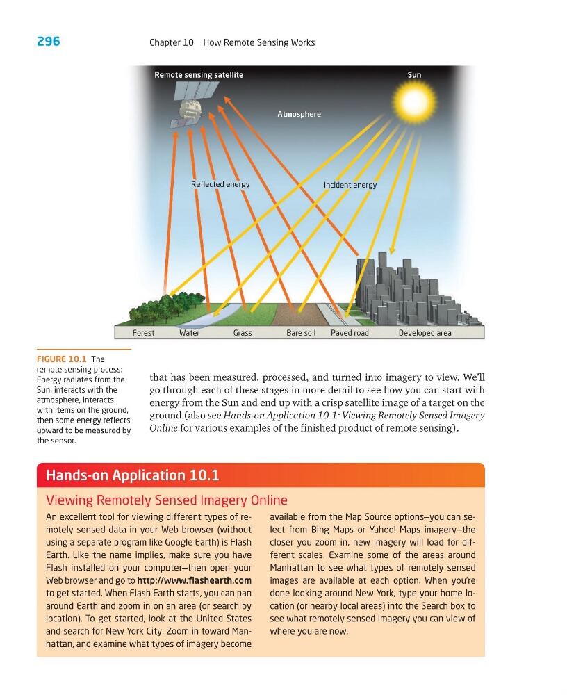
FIGURE 10.1 The
remote sensing process:
Energy radiates from the
Sun, interacts with the
atmosphere, interacts
with items on the ground,
then some energy reflects
upward to be measured by
the sensor.
An excellent tool for viewing different types of remotely sensed data in your Web browser (without
using a separate program like Google Earth) is Flash
Earth. Like the name implies, make sure you have
Flash installed on your computer—then open your
Web browser and go to http://www.flashearth.com
to get started. When Flash Earth starts, you can pan
around Earth and zoom in on an area (or search by
location). To get started, look at the United States
and search for New York City. Zoom in toward Manhattan, and examine what types of imagery become
available from the Map Source options—you can select from Bing Maps or Yahoo! Maps imagery—the
closer you zoom in, new imagery will load for different scales. Examine some of the areas around
Manhattan to see what types of remotely sensed
images are available at each option. When you’re
done looking around New York, type your home location (or nearby local areas) into the Search box to
see what remotely sensed imagery you can view of
where you are now.
Hands-on Application 10.1
Viewing Remotely Sensed Imagery Online
Forest
Water
Grass
Bare soil
Paved road
Developed area
Remote sensing satellite
Reflected energy
Reflected energy
Incident energy
Incident energy
Reflected energy
Incident energy
Atmosphere
Sun
Chapter 10 How Remote Sensing Works
that has been measured, processed, and turned into imagery to view. We’ll
go through each of these stages in more detail to see how you can start with
energy from the Sun and end up with a crisp satellite image of a target on the
ground (also see Hands-on Application 10.1: Viewing Remotely Sensed Imagery
Online for various examples of the finished product of remote sensing).
FIGURE 10.1 The
remote sensing process:
Energy radiates from the
Sun, interacts with the
atmosphere, interacts
with items on the ground,
then some energy reflects
upward to be measured by
the sensor.
An excellent tool for viewing different types of remotely sensed data in your Web browser (without
using a separate program like Google Earth) is Flash
Earth. Like the name implies, make sure you have
Flash installed on your computer—then open your
Web browser and go to http://www.flashearth.com
to get started. When Flash Earth starts, you can pan
around Earth and zoom in on an area (or search by
location). To get started, look at the United States
and search for New York City. Zoom in toward Manhattan, and examine what types of imagery become
available from the Map Source options—you can select from Bing Maps or Yahoo! Maps imagery—the
closer you zoom in, new imagery will load for different scales. Examine some of the areas around
Manhattan to see what types of remotely sensed
images are available at each option. When you’re
done looking around New York, type your home location (or nearby local areas) into the Search box to
see what remotely sensed imagery you can view of
where you are now.
Hands-on Application 10.1
Viewing Remotely Sensed Imagery Online
Forest
Water
Grass
Bare soil
Paved road
Developed area
Remote sensing satellite
Reflected energy
Reflected energy
Incident energy
Incident energy
Reflected energy
Incident energy
Atmosphere
Sun