

251
Geocoding and Shortest Path Analysis: AEJEE Version
2. GISlibraries.csv now contains all the library address information, plus a
latitude and longitude location value for each library. This information
will be used to plot their locations in AEJEE.
3. Start AEJEE. From the ‘Chapter8’ folder, add the tgr51810lka.shp
shapefile to the map (see Geospatial Lab Application 5.1 for the basics of
starting AEJEE and adding data to it). This shapefile is a TIGER 2000 file
of the Virginia Beach road network.
4. Open the TIGER file’s attribute table. You’ll see it contains 19,026
records, each representing a link of the city’s road network. You’ll also
see the standard TIGER file information of address ranges, census
feature class codes, and so on assigned to each link. You can close the
attribute table for now.
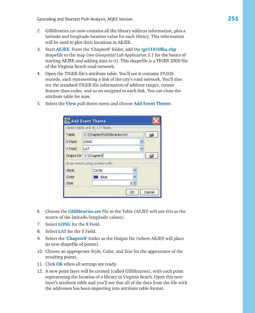
5. Select the View pull-down menu and choose Add Event Theme.
6. Choose the GISlibraries.csv file as the Table (AEJEE will use this as the
source of the latitude/longitude values).
7. Select LONG for the X Field.
8. Select LAT for the Y Field.
9. Select the ‘Chapter8’ folder as the Output Dir (where AEJEE will place
its new shapefile of points).
10. Choose an appropriate Style, Color, and Size for the appearance of the
resulting points.
11. Click OK when all settings are ready.
12. A new point layer will be created (called GISlibraries), with each point
representing the location of a library in Virginia Beach. Open this new
layer’s attribute table and you’ll see that all of the data from the file with
the addresses has been importing into attribute table format.
Geocoding and Shortest Path Analysis: AEJEE Version
2. GISlibraries.csv now contains all the library address information, plus a
latitude and longitude location value for each library. This information
will be used to plot their locations in AEJEE.
3. Start AEJEE. From the ‘Chapter8’ folder, add the tgr51810lka.shp
shapefile to the map (see Geospatial Lab Application 5.1 for the basics of
starting AEJEE and adding data to it). This shapefile is a TIGER 2000 file
of the Virginia Beach road network.
4. Open the TIGER file’s attribute table. You’ll see it contains 19,026
records, each representing a link of the city’s road network. You’ll also
see the standard TIGER file information of address ranges, census
feature class codes, and so on assigned to each link. You can close the
attribute table for now.
5. Select the View pull-down menu and choose Add Event Theme.
6. Choose the GISlibraries.csv file as the Table (AEJEE will use this as the
source of the latitude/longitude values).
7. Select LONG for the X Field.
8. Select LAT for the Y Field.
9. Select the ‘Chapter8’ folder as the Output Dir (where AEJEE will place
its new shapefile of points).
10. Choose an appropriate Style, Color, and Size for the appearance of the
resulting points.
11. Click OK when all settings are ready.
12. A new point layer will be created (called GISlibraries), with each point
representing the location of a library in Virginia Beach. Open this new
layer’s attribute table and you’ll see that all of the data from the file with
the addresses has been importing into attribute table format.